
File:AMH-6670-NA Map of the island of Formosa.jpg

預覽大小:800 × 554 像素。 其他解析度:320 × 222 像素 | 640 × 443 像素 | 1,024 × 709 像素 | 1,280 × 886 像素 | 2,400 × 1,662 像素。
原始檔案 (2,400 × 1,662 像素,檔案大小:691 KB,MIME 類型:image/jpeg)
摘要
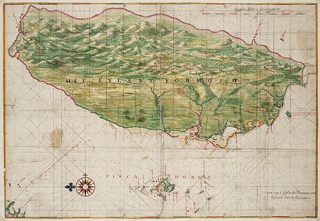
Nederlands: Kaart van het eiland Formosa
English: Map of the island of Formosa( |
||||||||||||||||||||||||
|---|---|---|---|---|---|---|---|---|---|---|---|---|---|---|---|---|---|---|---|---|---|---|---|---|
| 作者 |
Nederlands: Johannes Vingboons (landmeter / kaartenmaker)
English: Johannes Vingboons (land surveyor / mapmaker) |
|||||||||||||||||||||||
| 標題 |
Nederlands: Kaart van het eiland Formosa
English: Map of the island of Formosa |
|||||||||||||||||||||||
| 描述 |
Nederlands: Titel catalogus Leupe (Nationaal Archief): Kaart van de kusten van Formosa en de Pescadores.
Lodingen aangegeven op de kaart. Op de achterzijde zijn strookjes papier geplakt met daarop letters en woorden geschreven die echter geen samenhangende tekst vormen. De contouren van Formosa en de Pescadores zijn op deze kaart exact dezelfde als die in de Atlas Blaeu-Van der Hem uit de Österreichische Nationalbibiothek , Wenen, inv. nr. Van der Hem 41:02.English: Title in the Leupe catalogue (National Archives): Kaart van de kusten van Formosa en de Pescadores.
Soundings indicated on the chart. Strips of paper have been pasted on the reverse. The strips bear letters and words, but these do not combine into a coherent text. The outlines of The island Formosa and the Pescadores on this map are exactly the same as the ones on the map in the Atlas Blaeu-Van der Hem from the Österreichische Nationalbibiothek , Vienna, inv. nr. Van der Hem 41:02. |
|||||||||||||||||||||||
| 日期 | 約1665年 | |||||||||||||||||||||||
| 表現方法 |
Nederlands: aquarel/waterverf op papier
English: watercolour on paper |
|||||||||||||||||||||||
| 尺寸 | 高度:68釐米;寬度:47釐米 | |||||||||||||||||||||||
| 藏於 |
|
|||||||||||||||||||||||
| 登錄號 |
NL-HaNA_4.VELH_619.52 (old number: VELH0619.52) |
|||||||||||||||||||||||
| 題字 |
Het Eylant Formosa
|
|||||||||||||||||||||||
| 備註 |
English: Subjects: chart / map / plan, compass / dial
Nederlands: Onderwerpen: plattegrond / kaart, kompas / windroos
English: Post: this image is related to a VOC trading post called Chi-lung |
|||||||||||||||||||||||
| 來源/攝影者 |
|
|||||||||||||||||||||||
| 授權許可 (重用此檔案) |
|
|||||||||||||||||||||||
| 其他版本 |
|
|||||||||||||||||||||||


| 目標地點 | | 位於此地的本圖片與其他圖片: OpenStreetMap |
|---|
檔案歷史
點選日期/時間以檢視該時間的檔案版本。
| 日期/時間 | 縮圖 | 尺寸 | 用戶 | 備註 | |
|---|---|---|---|---|---|
| 目前 | 2014年6月11日 (三) 09:39 | | 2,400 × 1,662(691 KB) | HuskyBot | == {{int:filedesc}} == {{Artwork |title = {{nl|1=Kaart van het eiland Formosa}} {{en|1=Map of the island of Formosa}} |description = {{nl|1=Titel catalogus Leupe (Nationaal Archief): ''Kaart van de kusten van F... |
檔案用途
下列頁面有用到此檔案:
全域檔案使用狀況
以下其他 wiki 使用了這個檔案:
- ast.wikipedia.org 的使用狀況
- en.wikipedia.org 的使用狀況
- es.wikipedia.org 的使用狀況
- fy.wikipedia.org 的使用狀況
- mt.wikipedia.org 的使用狀況
- nl.wikipedia.org 的使用狀況
- tr.wikipedia.org 的使用狀況