
File:BullBottoms-11.22 09.JPG

原始檔案 (1,024 × 768 像素,檔案大小:311 KB,MIME 類型:image/jpeg)
摘要
| 描述 |
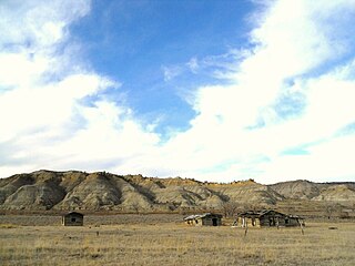
English: Homestead Buildings, Bull Creek Bottoms, Missouri Breaks, Montana |
| 日期 | |
| 來源 | own, all rights released |
| 作者 | montana geographical society |
| 授權許可 (重用此檔案) |
Permission is granted to copy, distribute and/or modify this document under the terms of the GNU Free Documentation License, |
The three buildings are remnants of homestead buildings at Bull Creek Bottom, adjacent to Cow Creek Bottom in the Missouri Breaks of Montana. Bull Creek Bottom is about 21 to 22 miles above the Fred Robinson Bridge on the Missouri, (where U.S. Highway 161 crosses the Missouri River in the breaks)and about 25 miles northeast of Winifred, MT. The view is looking south down to the mouth of Bull Creek, toward the Missouri River which runs along the base of the bluffs in the distance. Cow Island is located at this point in the Missouri. The homestead is located in an isolated remote portion of the Missouri Breaks in Montana. The breaks are so named because of the rough badland-type terrain extending out on either side of the Missouri River for over a hundred miles. The area is mostly traversed by dirt roads which literally become impassible when wet, because the soil in this area contain bentonite which causes mud to cake up around the wheels of any vehicle.
授權條款
| 我,此作品的版權所有人,釋出此作品至公共領域。此授權條款在全世界均適用。 這可能在某些國家不合法,如果是的話: 我授予任何人有權利使用此作品於任何用途,除受法律約束外,不受任何限制。 |
檔案歷史
點選日期/時間以檢視該時間的檔案版本。
| 日期/時間 | 縮圖 | 尺寸 | 用戶 | 備註 | |
|---|---|---|---|---|---|
| 目前 | 2024年4月18日 (四) 07:57 | | 1,024 × 768(311 KB) | Beao | Removed watermark |
| 2011年2月6日 (日) 23:05 |  | 1,024 × 768(184 KB) | NoAmGeogSoc | {{Information |Description ={{en|1=Homestead Buildings, Bull Creek Bottoms, Missouri Breaks, Montana}} |Source =own, all rights released |Author =montana geogaphical society |Date =2009-11-22 |Permission =Permission is gra |
檔案用途
下列頁面有用到此檔案:
全域檔案使用狀況
以下其他 wiki 使用了這個檔案:
- en.wikipedia.org 的使用狀況