
File:CalabrianArc-GeotectonicSection.jpg

原始檔案 (5,974 × 1,629 像素,檔案大小:3.61 MB,MIME 類型:image/jpeg)
摘要
| 描述 |
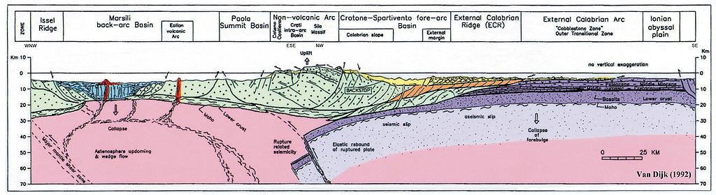
English: This picture (van Dijk, 1992, published also in van Dijk, 1994, and coloured versions are in van Dijk et al. 1998, 2000; reproduced by many other authors) shows a geological, geotectonic, structural section of the Central Mediterranean Subduction System, i.e. the Calabrian Arc.
All authors reproducing this figure in their work in original or modified form are kindly requested to correctly refer to the original source according to standard scientific ethics codes. It is an original compilation of the present knowledge regarding this complex system, and numerous references and discussions regarding previous knowledge can be found in the extensive bibliographies of van Dijk & Okkes (1990), van Dijk (1992) and van Dijk et al. (2000). The legend of the colours and the position of the section trace can be found on the map of the Central Mediterranean: http://commons.wikimedia.org/wiki/File:CentralMediterranean-GeotectonicMap.jpg It shows the overthrusting of the Calabrian Block also called "Calabrian Element", representing the southern Apennines and the Sicilian Maghrebides, of the promontory of the African Plate, the Ionian Sea. Furthermore the Tyrrhenian back-arc basin is shown with its recent volcanic arcs and tectonic stretching. It is underlined here that the internal structure of this Calabrian Block is only generally indicated in this figure; it is composed of a complex nappes pile dissected and deformed by transpressional fault zones, all generated during Late Eocene up to mid Pleistocene deformation phases. More details of this complex internal structure are depicted in the copyright protected figures of Van Dijk et al. (2000), which hopefully will soon become available in Wikipedia. It can be appreciated that the Calabrian Block is moving towards the southeast along a detachment plane situated at a depth of around 15 to 25 km which dips to the southeast, and therefore suggests an important component of gravitational forces guiding the sliding of this lithosphere element, as underlined by many researchers in the past, and more recently revisited in the scientific literature. How these gravitational forces may interact and alternate with interplate and intraplate stress components related to the regional plate movements in the central Mediterranean is extensively discussed in van Dijk and Okkes (1991) and later works. Domains that can be recognised include the Issel Ridge, The Marsili Basin, the Paola Basin, the Crotone Basin, also called Spartivento Basin, the external Calabrian Arc and the Ionian Abyssal Plain. The rupture of the subducted slab below the arc and its consequences in terms of isostatic restablisation, astenospheric wedging and other, can be appreciated. These are all extensively discussed in van Dijk and Okkes (1990) and van Dijk and Scheepers (1995). Another important phenomenon that is underlined in the figure is the incipient, start of subduction, of the Tyrrhenian crust, with a vergence of contraction towards the inner margin of the Arc, first proposed by van Dijk & Okkes (1990, 1991) and recently recognized also in other Mediterranean margins such as western North Africa.
van Dijk, J.P., and Okkes, F.W.M. (1988); The analysis of shear zones in Calabria. implications for the geodynamics of the Central Mediterranean. La Ricerca Scient., Suppl., 68, 24-27. van Dijk, J.P., and Okkes, F.W.M. (1990); The analysis of shear zones in Calabria. implications for the geodynamics of the Central Mediterranean. Riv. Ital. Strat. Paleont., 96 (2-3), 241-270. van Dijk, J.P., and Okkes, F.W.M. (1991); Neogene tectonostratigraphy and kinematics of Calabrian Basins. implications for the geodynamics of the Central Mediterranean. Tectonophysics, 196, 23-60. van Dijk, J.P. (1992); Late Neogene fore-arc basin evolution in the Calabrian Arc (Central Mediterranean). Tectonic sequence stratigraphy and dynamic geohistory. With special reference to the geology of Central Calabria. Geologica Ultrajectina, 92, 288 pp. van Dijk, J.P., and Scheepers, P.J.J. (1995); Neogene rotations in the Calabrian Arc. Implications for a Pliocene-Recent geodynamic scenario for the Central Mediterranean. Earth Sci. Rev., 39, 207-246. van Dijk, J.P., Barberis, A., Cantarella, G., and Massa, E. (1998); Central Mediterranean Messinian basin evolution. Tectono-eustasy or eustato-tectonics? Annales Tectonicae, 12, n. 1-2, 7-27. van Dijk, J.P., Bello, M., Brancaleoni, G.P., Cantarella, G., Costa, V., Frixa, A., Golfetto, F., Merlini, S., Riva, M., Toricelli, S., Toscano, C., and Zerilli, A. (2000); A new structural model for the northern sector of the Calabrian Arc. Tectonophysics, 324, 267-320. van Dijk, J.P., Bello, M., Toscano, C., Bersani, A., and Nardon, S. (2000); Tectonic model and 3D fracture network analysis of Monte Alpi (Southern Apennines). Tectonophysics, 324, 203-237. |
| 日期 | |
| 來源 | van Dijk, J.P. (1992); ; Late Neogene fore-arc basin evolution in the Calabrian Arc (Central Mediterranean). Tectonic sequence stratigraphy and dynamic geohistory. With special reference to the geology of Central Calabria. Geologica Ultrajectina, Vol. 92, pp. 57, Fig. 1b. |
| 作者 | Jpvandijk, J.P. van Dijk, Janpieter van Dijk, Johannes Petrus van Dijk |
| 授權許可 (重用此檔案) |
This is my own file. I created it and it is published in my public domain Ph.D. Thesis. |
授權條款

|
已授權您依據自由軟體基金會發行的無固定段落、封面文字和封底文字GNU自由文件授權條款1.2版或任意後續版本,對本檔進行複製、傳播和/或修改。該協議的副本列在GNU自由文件授權條款中。 |
- 您可以自由:
- 分享 – 複製、發佈和傳播本作品
- 重新修改 – 創作演繹作品
- 惟需遵照下列條件:
- 姓名標示 – 您必須指名出正確的製作者,和提供授權條款的連結,以及表示是否有對內容上做出變更。您可以用任何合理的方式來行動,但不得以任何方式表明授權條款是對您許可或是由您所使用。
- 相同方式分享 – 如果您利用本素材進行再混合、轉換或創作,您必須基於如同原先的相同或兼容的條款,來分布您的貢獻成品。
檔案歷史
點選日期/時間以檢視該時間的檔案版本。
| 日期/時間 | 縮圖 | 尺寸 | 用戶 | 備註 | |
|---|---|---|---|---|---|
| 目前 | 2010年6月14日 (一) 09:08 | 5,974 × 1,629(3.61 MB) | Jpvandijk | Indications of geographic orientation of the section. Some cleaning. | |
| 2010年6月13日 (日) 11:30 | 5,974 × 1,629(3.6 MB) | Jpvandijk | The correct color is inserted for the external tectonic units and some Neogene deposits, in order to comply better to the linked Geotectonic Map. | ||
| 2010年6月12日 (六) 11:36 | 5,974 × 1,629(3.6 MB) | Jpvandijk | File name and some resolution enhancement. | ||
| 2010年5月24日 (一) 12:04 | 5,974 × 1,629(3.6 MB) | Jpvandijk | The rectangular box indicating the "field study area" has been removed, as was done by other authors that reproduced the picture, to make it still more general in its usage in scientific publications. | ||
| 2010年5月24日 (一) 11:59 | 5,974 × 1,629(3.6 MB) | Jpvandijk | The rectangular box indicating the area "field study area" has been removed, as was done by other authors that reproduced the picture, to make it still more general in its usage in scientific publications. | ||
| 2010年5月22日 (六) 12:51 | 5,974 × 1,629(3.6 MB) | Jpvandijk | The white surrounding areas of the picture have been removed. | ||
| 2010年5月22日 (六) 12:32 |  | 9,925 × 7,017(2.56 MB) | Jpvandijk | {{Information |Description={{en|1=This picture (van Dijk, 1992, published also in van Dijk, 1994, and coloured versions are in van Dijk et al. 1998, 2000; reproduced by many other authors) shows a geological, geotectonic, structural section of the Central |
檔案用途
下列頁面有用到此檔案:
全域檔案使用狀況
以下其他 wiki 使用了這個檔案:
- bg.wikipedia.org 的使用狀況
- de.wikipedia.org 的使用狀況
- en.wikipedia.org 的使用狀況
- it.wikipedia.org 的使用狀況
- pcd.wikipedia.org 的使用狀況
- ru.wikipedia.org 的使用狀況