
File:Carte Guerre de Sept Ans Europe.PNG
預覽大小:800 × 582 像素。 其他解析度:320 × 233 像素 | 640 × 466 像素 | 884 × 643 像素。
原始檔案 (884 × 643 像素,檔案大小:77 KB,MIME 類型:image/png)
Incorrect Information
- After the Russian-Swedisch war of 1741–1743 Finnland was russian in the East, up to the river Kymijoki, and Swedish in the western part. --El bes (talk) 21:02, 10 August 2008 (UTC)
An even bigger error here is that the UK, formed in 1707, is listed as England. Also, Ireland didn't join the Union until 1801, and at the time was still a kingdom in its own right.
Poland should be shown as the Polish-Lithuanian Commonwealth.
Austro-Ottoman borders shown here are actually from 1718-1739 period, between Treaty of Požarevac and Treaty of Belgrade

|
本圖片是以PNG、GIF或JPEG格式上傳。然而,其中包含的資料或訊息,應該重新建立成可縮放向量圖形(SVG)檔案,以更有效率或更準確的方式儲存。如有可能,請上傳本圖片的SVG格式版本。在上傳之後,請修改維基各姊妹計畫中所有使用舊版圖片的條目(列在圖像連結章節中),替換為新版圖片,並在舊圖片的描述頁中加入{{Vector version available|新圖片名稱.svg}}模板,同時移除本模板。
|
摘要
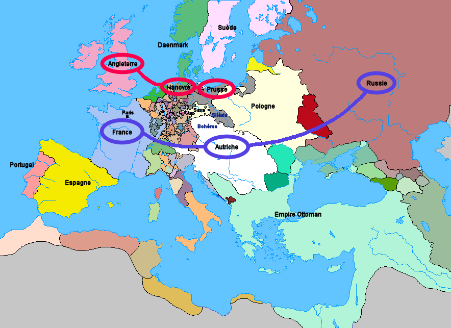
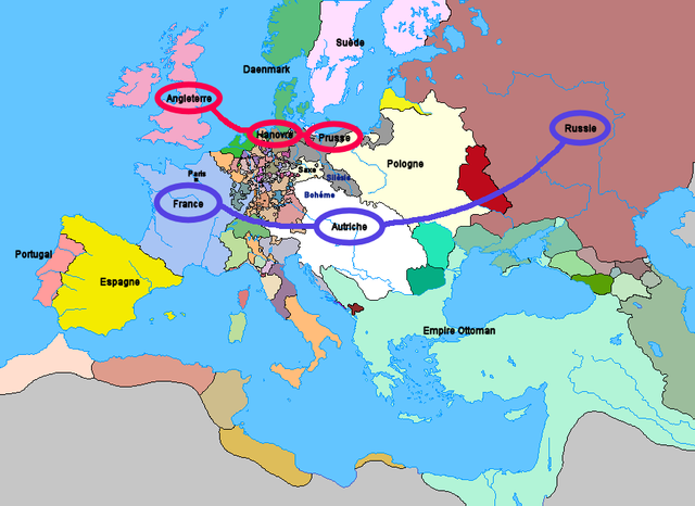
Carte de l'Europe et des alliances à la veille de la guerre de Sept Ans (1757)
授權條款
上傳: Wordelle
| 我,此作品的版權所有人,釋出此作品至公共領域。此授權條款在全世界均適用。 這可能在某些國家不合法,如果是的話: 我授予任何人有權利使用此作品於任何用途,除受法律約束外,不受任何限制。 |
无法识别来源。根据版权声明推断为其自己的作品。
檔案歷史
點選日期/時間以檢視該時間的檔案版本。
| 日期/時間 | 縮圖 | 尺寸 | 用戶 | 備註 | |
|---|---|---|---|---|---|
| 目前 | 2012年1月1日 (日) 21:25 | | 884 × 643(77 KB) | Artemis Dread | Republic of Ragusa |
| 2011年12月24日 (六) 22:19 |  | 884 × 643(77 KB) | Artemis Dread | Prince-Bishopric of Montenegro | |
| 2011年9月18日 (日) 10:58 |  | 884 × 643(77 KB) | Artemis Dread | Kingdom of Imereti and Kingdom of Kartli-Kakheti, minor changes | |
| 2011年9月17日 (六) 14:31 |  | 884 × 643(76 KB) | Artemis Dread | Finland | |
| 2011年9月17日 (六) 13:15 |  | 884 × 643(76 KB) | Artemis Dread | minor changes | |
| 2011年9月17日 (六) 12:17 |  | 884 × 643(76 KB) | Artemis Dread | Duchy of Courland and Semigallia | |
| 2011年9月17日 (六) 11:13 |  | 884 × 643(76 KB) | Artemis Dread | Cossack Hetmanate | |
| 2011年9月17日 (六) 10:36 |  | 884 × 643(76 KB) | Artemis Dread | vassals of the Ottoman Empire | |
| 2006年10月18日 (三) 09:30 |  | 884 × 643(72 KB) | Wordelle | Carte de l'Europe et des alliances à la veille de la guerre de Sept Ans (1757) |
檔案用途
下列3個頁面有用到此檔案:
全域檔案使用狀況
以下其他 wiki 使用了這個檔案:
- af.wikipedia.org 的使用狀況
- ar.wikipedia.org 的使用狀況
- az.wikipedia.org 的使用狀況
- bg.wikipedia.org 的使用狀況
- br.wikipedia.org 的使用狀況
- ca.wikipedia.org 的使用狀況
- cs.wikipedia.org 的使用狀況
- de.wikipedia.org 的使用狀況
- el.wikipedia.org 的使用狀況
- en.wikipedia.org 的使用狀況
- Military history of the Russian Empire
- Diplomatic Revolution
- Portal:Russia/Selected anniversaries
- Portal:Russia/Selected anniversaries/May
- Stately quadrille
- Wenzel Anton, Prince of Kaunitz-Rietberg
- History of the foreign relations of the United Kingdom
- User:Rjensen/International relations 1648-1814
- User:Falcaorib/Europe
- es.wikipedia.org 的使用狀況
- et.wikipedia.org 的使用狀況
- eu.wikipedia.org 的使用狀況
- fr.wikipedia.org 的使用狀況
- fr.wikiversity.org 的使用狀況
- he.wikipedia.org 的使用狀況
- hu.wikipedia.org 的使用狀況
- id.wikipedia.org 的使用狀況
- it.wikipedia.org 的使用狀況
- ja.wikipedia.org 的使用狀況
- la.wikipedia.org 的使用狀況
- lv.wikipedia.org 的使用狀況
- ms.wikipedia.org 的使用狀況
- nl.wikipedia.org 的使用狀況
- nn.wikipedia.org 的使用狀況
- no.wikipedia.org 的使用狀況
- ro.wikipedia.org 的使用狀況
- ru.wikipedia.org 的使用狀況
- sh.wikipedia.org 的使用狀況
- sr.wikipedia.org 的使用狀況
- sv.wikipedia.org 的使用狀況
- sw.wikipedia.org 的使用狀況
- th.wikipedia.org 的使用狀況
- tr.wikipedia.org 的使用狀況
檢視此檔案的更多全域使用狀況。