
File:Carte la plus generale et qui comprend la Chine, la Tartarie Chinoise, et le Thibet (1734).jpg

預覽大小:800 × 562 像素。 其他解析度:320 × 225 像素 | 640 × 449 像素 | 1,024 × 719 像素 | 1,280 × 899 像素 | 2,560 × 1,797 像素 | 3,000 × 2,106 像素。
原始檔案 (3,000 × 2,106 像素,檔案大小:3.14 MB,MIME 類型:image/jpeg)
摘要
| 描述 |
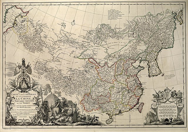
Français : Carte la plus generale et qui comprend la Chine, la Tartarie Chinoise, et le Thibet. Dressee sur les cartes particuliers des RR PP Jesuites, par le Sr. d'Anville..., qui ya joint le pays compris entre Kashgar et la mar Caspienne, tire des geographes et des historiens orientaux
English: A most general map, including China, Chinese Tartary, and Tibet, based on individual maps of the Jesuit fathers. The map gives 1734 as the year, but the modern HKUST publishers say 1737
English: Entire map
"D’Anville’s maps of China were based on a survey of the Chinese empire that was ordered by the emperor in 1708 and carried out by the Chinese, but under the supervision of Jesuit priests resident in China. The detail about the interior of China was far superior to any previous Western map or atlas. D’Anville’s work remained a standard Western source for the geography of China and adjacent regions until well into the 19th century, when it finally was superseded by more accurate maps." — (World Digital Library) 中文:清廷于1708年组织在华法国传教士蒋友仁等进行大规模大地测量,以经纬为基础,测绘编成《皇兴全览图》。该图编成后,被视为珍秘,秘藏大内,而其资料宝已流入欧洲,法国皇家地理官唐维尔(D’anville)编辑,于1737年将皇兴全览图出版,经增补修订,改名《中国新地图集》即此书。故此书是康熙时中国大地测量后最早公开的成果,包括彩印总图两幅,分省图十五幅,边外二十五幅,计42幅。此书羊此装,纸张为带徽记的水印纸印刷。 |
| 日期 | reprint still dated 1734 |
| 來源 | [1] |
| 作者 | |
| 授權許可 (重用此檔案) |
Author died more than 70 years ago - public domain |
| 其他版本 |
Regional Maps
|


.jpg)


.jpg?uselang=zh-hk)
.jpg?uselang=zh-hk)
.jpg?action=history&uselang=zh-hk)
.jpg)
|
本作品在其來源國以及其他版權期限是作者逝世後100年或以下的國家與地區屬於公有領域。 | |
| 此作品無已知的著作權限制,亦不受所有相關和鄰接的權利限制。 | |
檔案歷史
點選日期/時間以檢視該時間的檔案版本。
| 日期/時間 | 縮圖 | 尺寸 | 用戶 | 備註 | |
|---|---|---|---|---|---|
| 目前 | 2022年1月12日 (三) 08:33 | | 3,000 × 2,106(3.14 MB) | Rabanus Flavus | {{Information |Description={{fr|Carte la plus generale et qui comprend la Chine, la Tartarie Chinoise, et le Thibet. Dressee sur les cartes particuliers des RR PP Jesuites, par le Sr. d'Anville..., qui ya joint le pays compris entre Kashgar et la mar Caspienne, tire des geographes et des historiens orientaux}} {{en|A most general map, including China, Chinese Tartary, and Tibet, based on individual maps of the Jesuit fathers. The map gives 1734 as the year, but the modern HKUST publishers say... |
檔案用途
下列頁面有用到此檔案:
全域檔案使用狀況
以下其他 wiki 使用了這個檔案:
- be.wikipedia.org 的使用狀況
- da.wikipedia.org 的使用狀況
- de.wikipedia.org 的使用狀況
- en.wikipedia.org 的使用狀況
- es.wikipedia.org 的使用狀況
- fi.wikipedia.org 的使用狀況
- fr.wikipedia.org 的使用狀況
- hr.wikipedia.org 的使用狀況
- hy.wikipedia.org 的使用狀況
- id.wikipedia.org 的使用狀況
- ka.wikipedia.org 的使用狀況
- no.wikipedia.org 的使用狀況
- pt.wikipedia.org 的使用狀況
- ru.wikipedia.org 的使用狀況
- tr.wikipedia.org 的使用狀況
- uk.wikipedia.org 的使用狀況
- uz.wikipedia.org 的使用狀況
- vi.wikipedia.org 的使用狀況
.jpg)