
File:EtoshaBorders.jpg
預覽大小:800 × 365 像素。 其他解析度:320 × 146 像素 | 640 × 292 像素 | 1,406 × 642 像素。
原始檔案 (1,406 × 642 像素,檔案大小:276 KB,MIME 類型:image/jpeg)
摘要
| 描述 |
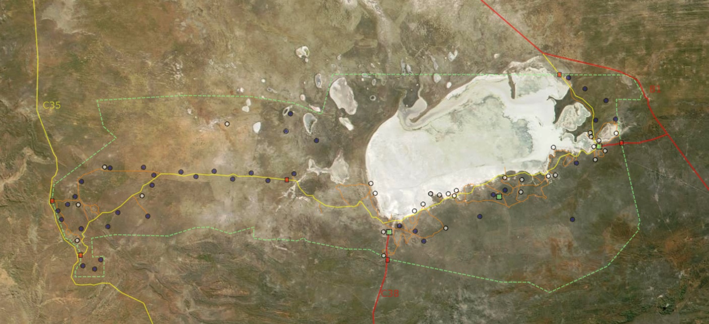
Deutsch: Satellitenbild vom Etosha Park mit Grenzen, Wegen, Wasserstellen, Camps und Toren
English: Satellite picture of Etosha park with borders, roads, waterpoints, camps and gates
Français : Vue satellite de la réserve naturelle d'Etosha, avec les limites, chemins, points d'eau, camps et portes
English: Satellite picture of the park
Français : Vue satellite du parc naturel d'Etosha
Suomi: Etoshan kansallispuisto satelliittikuvassa |
| 日期 | |
| 來源 | NASA |
| 作者 | Modified by Harald Süpfle |
| 授權許可 (重用此檔案) |
NASA public domain |
| 其他版本 | cut out of original NASA file (3600x4800): ev11707_Namibia.A2001131.0920.250m.jpg |
授權條款
| 本作品由NASA創作,屬於公有領域。根據NASA的版權政策:“NASA的創作除非另有聲明否則不受版權保護。”(參見:Template:PD-USGov/zh,NASA版權政策或JPL圖像使用政策) | ||
 |
警告:
|
檔案歷史
點選日期/時間以檢視該時間的檔案版本。
| 日期/時間 | 縮圖 | 尺寸 | 用戶 | 備註 | |
|---|---|---|---|---|---|
| 目前 | 2006年12月18日 (一) 22:39 | | 1,406 × 642(276 KB) | Hsuepfle | {{Created with Inkscape}} {{Information| |Description = '''de:''' Satellitenbild vom Etosha Park mit Grenzen, Wegen, Wasserstellen, Camps und Toren * rote linie: Teerstraße * gelbe Linie: Piste * Rotes Quadrat: Parktor * Grünes Quadrat: Camp * Blauer K |
| 2006年1月6日 (五) 22:47 |  | 1,150 × 504(176 KB) | Hsuepfle | {{Information| |Description = de: Satellitenbild vom Etosha Park mit Grenzen, Wegen, Wasserlöchern, Camps und Toren en: Satellite picture of Etosha park with borders, roads, Water holes, Camps and Gates |Source = NASA |Date = 2006-01-06 |Author = Modif |
檔案用途
下列頁面有用到此檔案:
全域檔案使用狀況
以下其他 wiki 使用了這個檔案:
- af.wikipedia.org 的使用狀況
- be.wikipedia.org 的使用狀況
- bg.wikipedia.org 的使用狀況
- de.wikipedia.org 的使用狀況
- en.wikipedia.org 的使用狀況
- eo.wikipedia.org 的使用狀況
- es.wikipedia.org 的使用狀況
- fi.wikipedia.org 的使用狀況
- hu.wikipedia.org 的使用狀況
- it.wikipedia.org 的使用狀況
- lt.wikipedia.org 的使用狀況
- no.wikipedia.org 的使用狀況
- pnb.wikipedia.org 的使用狀況
- sk.wikipedia.org 的使用狀況
- sl.wikipedia.org 的使用狀況
- vi.wikipedia.org 的使用狀況