
File:Iberian Peninsula in 125-en.svg

此 SVG 檔案的 PNG 預覽的大小:720 × 576 像素。 其他解析度:300 × 240 像素 | 600 × 480 像素 | 960 × 768 像素 | 1,280 × 1,024 像素 | 2,560 × 2,048 像素。
原始檔案 (SVG 檔案,表面大小:720 × 576 像素,檔案大小:1.07 MB)
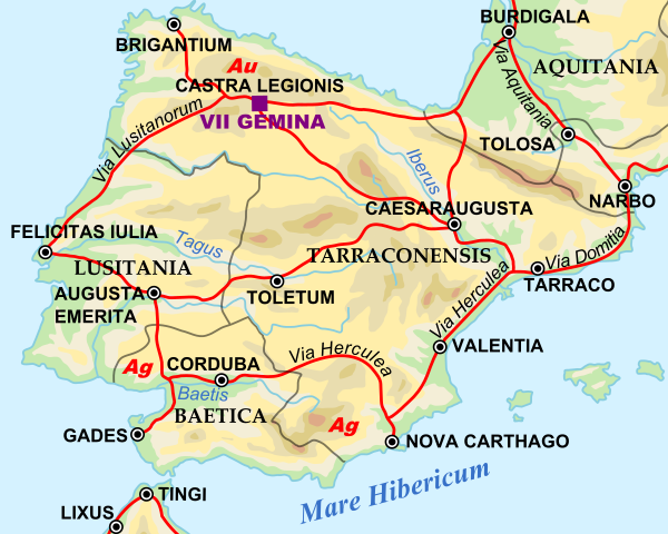
| 描述 | Shows Iberian peninsula in 125 including important roads, legionnaire locations and gold/silver mines. "NOTE: Barbarian names and locations as in the works of Tacitus (written ca. 100 AD)" |
| 日期 | |
| 來源 | |
| 作者 |
|
SVG Support
This document is in the Scalable Vector Graphic format (SVG) and requires a supported browser (Firefox, Google Chrome, Opera) or a SVG plugin for Internet Explorer and other browsers. SVG is an open source format, which means this map can be downloaded and modified/translated completely using a vector graphics editor like Adobe Illustrator or Inkscape (free) or a text editor such as Notepad.
| BLANK THUMBNAIL | View large PNG | View medium PNG | SVG Plugin for Internet Explorer and other browsers |
|---|---|---|---|
| Click here (purge cache) and then CTRL+F5 to reload. Help? | Try 1 Try 2 | Try 1 Try 2 | Adobe SVG plugin |
| Recommended browser | More Help | ||
| Firefox | List of SVG tools |
| 這是一張修飾過的圖片,即本圖片是用軟體修改過後的版本,修改的方式或內容有:Zoomed in to Iberian peninsula。原版圖片來源:Roman Empire 125.svg。
|
| 我,此作品的版權所有人,釋出此作品至公共領域。此授權條款在全世界均適用。 這可能在某些國家不合法,如果是的話: 我授予任何人有權利使用此作品於任何用途,除受法律約束外,不受任何限制。 |
原始上傳日誌
This image is a derivative work of the following images:
- File:Roman_Empire_125.svg licensed with PD-user-en, PD-user-w, PD-user-w/de
Uploaded with derivativeFX
檔案歷史
點選日期/時間以檢視該時間的檔案版本。
| 日期/時間 | 縮圖 | 尺寸 | 用戶 | 備註 | |
|---|---|---|---|---|---|
| 目前 | 2009年4月29日 (三) 10:45 | | 720 × 576(1.07 MB) | ArdadN | update2 |
| 2009年4月29日 (三) 10:40 |  | 720 × 576(1.07 MB) | ArdadN | update | |
| 2009年3月28日 (六) 20:21 |  | 720 × 576(1.07 MB) | Malus Catulus | {{Information |Description=Shows Iberian peninsula in 125 including important roads, legionnaire locations and gold/silver mines. "NOTE: Barbarian names and locations as in the works of Tacitus (written ca. 100 AD)" |Source=*[[:File:Roman_Empire_125.svg| |
檔案用途
下列2個頁面有用到此檔案:
全域檔案使用狀況
以下其他 wiki 使用了這個檔案:
- arz.wikipedia.org 的使用狀況
- ast.wikipedia.org 的使用狀況
- bg.wikipedia.org 的使用狀況
- bs.wikipedia.org 的使用狀況
- el.wikipedia.org 的使用狀況
- en.wikipedia.org 的使用狀況
- es.wikipedia.org 的使用狀況
- et.wikipedia.org 的使用狀況
- eu.wikipedia.org 的使用狀況
- fi.wikipedia.org 的使用狀況
- fr.wikipedia.org 的使用狀況
- hr.wikipedia.org 的使用狀況
- hu.wikipedia.org 的使用狀況
- hy.wikipedia.org 的使用狀況
- it.wikipedia.org 的使用狀況
- ja.wikipedia.org 的使用狀況
- ko.wikipedia.org 的使用狀況
- la.wikipedia.org 的使用狀況
- lv.wikipedia.org 的使用狀況
- nl.wikipedia.org 的使用狀況
- pt.wikiversity.org 的使用狀況
- ru.wikipedia.org 的使用狀況
- sh.wikipedia.org 的使用狀況
- sl.wikipedia.org 的使用狀況
- sv.wikipedia.org 的使用狀況
- th.wikipedia.org 的使用狀況
檢視此檔案的更多全域使用狀況。