
File:Inverted channels Mars PIA08070.jpg

預覽大小:254 × 598 像素。 其他解析度:102 × 240 像素 | 204 × 480 像素 | 651 × 1,533 像素。
原始檔案 (651 × 1,533 像素,檔案大小:147 KB,MIME 類型:image/jpeg)

|
此檔案是透過機器人腳本從en.wikipedia移動到維基共享資源的。來源中的所有資訊均已保留,但仍需要人工的審閱。部分或所有的資訊可能會出現在錯誤的區域;只有在經過審閱並修正需改正的錯誤後,此檔案的相關資訊才能視為可使用。當審閱結束後,請移除本模板,更詳細的資訊參見下方。 現在就開始檢查! |
| 描述 |
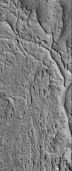
English: Original Caption Released with Image:
13 April 2006 This Mars Global Surveyor (MGS) Mars Orbiter Camera (MOC) image shows ridges exposed by erosion in the Aeolis region of Mars. The curved and crisscrossing ridges were once channels in a fan of sediment deposited in the Aeolis lowlands. The channels were more resistant to wind erosion than the surrounding materials, so today they are left standing as ridges rather than valleys. Location near: 6.1°S, 209.0°W Image width: ~3 km (~1.9 mi) Illumination from: lower left Season: Southern Summer Image Credit: NASA/JPL/Malin Space Science Systems Original image found at: [1] |
| 來源 | |
| 作者 |
授權條款
| 本作品由NASA創作,屬於公有領域。根據NASA的版權政策:“NASA的創作除非另有聲明否則不受版權保護。”(參見:Template:PD-USGov/zh,NASA版權政策或JPL圖像使用政策) | ||
 |
警告:
|
原始上傳日誌
The original description page was here. All following user names refer to en.wikipedia.
- 2006-07-11 15:34 Cuppysfriend 651×1533× (150950 bytes) Original Caption Released with Image: 13 April 2006 This [[Mars Global Surveyor]] (MGS) Mars Orbiter Camera (MOC) image shows ridges exposed by erosion in the Aeolis region of [[Mars]]. The curved and crisscrossing ridges were once channels in a fan of s
檔案歷史
點選日期/時間以檢視該時間的檔案版本。
| 日期/時間 | 縮圖 | 尺寸 | 用戶 | 備註 | |
|---|---|---|---|---|---|
| 目前 | 2009年5月28日 (四) 22:11 | | 651 × 1,533(147 KB) | File Upload Bot (Magnus Manske) | {{BotMoveToCommons|en.wikipedia|year={{subst:CURRENTYEAR}}|month={{subst:CURRENTMONTHNAME}}|day={{subst:CURRENTDAY}}}} {{Information |Description={{en|Original Caption Released with Image: 13 April 2006 This en:Mars Global Surveyor (MGS) Mars Orbi |
檔案用途
全域檔案使用狀況
以下其他 wiki 使用了這個檔案:
- en.wikipedia.org 的使用狀況