
File:Kuunga2.png

預覽大小:750 × 600 像素。 其他解析度:300 × 240 像素 | 600 × 480 像素 | 960 × 768 像素 | 1,150 × 920 像素。
原始檔案 (1,150 × 920 像素,檔案大小:153 KB,MIME 類型:image/png)

|
本圖片是以PNG、GIF或JPEG格式上傳。然而,其中包含的資料或訊息,應該重新建立成可縮放向量圖形(SVG)檔案,以更有效率或更準確的方式儲存。如有可能,請上傳本圖片的SVG格式版本。在上傳之後,請修改維基各姊妹計畫中所有使用舊版圖片的條目(列在圖像連結章節中),替換為新版圖片,並在舊圖片的描述頁中加入{{Vector version available|新圖片名稱.svg}}模板,同時移除本模板。
|
摘要
| 描述 |
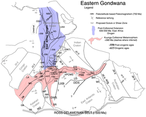
English: Paleotectonic map of eastern Gondwana with the Pan-African and/or circum-Antarctic orogenic (“mobile”) belts highlighted by age differences (See Fitzsimons, 2000a, cited in Meert, 2003, follow source link below). Meaning of abbreviations: Af = Afif terrane (Saudi Arabia); AFB = Albany-Fraser Belt (Australia); AS = Angavo shear zone (Madagascar); BH = Bunger Hills (Antarctica); BR = Bongolava-Ranotsara shear zone (Madagascar); BS = Betsimisaraka suture zone (Madagascar); DB = Damara Belt (Africa); DDS = Darling-Denman suture (Antarctica - Australia); DG = Denman Glacier (Antarctica); DMS = Dronning Maud suture (Antarctica); EG = Eastern Ghats (India); GB = Gariep Belt (Africa); HC = Highland Complex (Sri Lanka); LA = Lufilian Arc (Africa); LG = Lambert Graben (Antarctica); LHB = Lützow-Holm Belt (Antarctica); MD = Mwembeshi Dislocation (Africa); MP = Maud Province (Antarctica); NBS = Nabitah Suture (Arabia); nPCSM = Northern Prince Charles Mountains (Antarctica); NQ = Namaqua Belt (Africa); OSH = Onib-Sol Hamed suture (Arabia); PBB = Prydz Bay Belt (Antarctica); PC = Paughat-Cauvery (India); SB = Saldania Belt (Africa); SR = Shackelton Range (Antarctica) ; UAA = Urd Al Amar suture (Arabia); VC = Vijayan Complex (Sri Lanka); WC = Wanni Complex (Sri Lanka); WI = Windmill Islands (Antarctica); ZB = Zambezi Belt (Africa). |
| 日期 | (UTC) |
| 來源 | Kuunga2.jpg |
| 作者 |
|
授權條款
我,本作品的著作權持有者,決定用以下授權條款發佈本作品:
| |
此作品已由其作者,[[::|中文維基百科]]專案的Example,釋出至公有領域。此授權條款在全世界均適用。 如果法律不適用時: |
原始上傳日誌
This image is a derivative work of the following images:
- File:Kuunga2.jpg licensed with PD-user-w
- 2008-02-29T10:16:24Z File Upload Bot (Magnus Manske) 1000x785 (220296 Bytes) {{BotMoveToCommons|en.wikipedia}} {{Information |Description={{en|http://www.clas.ufl.edu/users/jmeert/kuunga.jpg adapted from: Meert, J.G., A synopsis of events related to the assembly of eastern Gondwana, Tectonophysics,
Uploaded with derivativeFX
檔案歷史
點選日期/時間以檢視該時間的檔案版本。
| 日期/時間 | 縮圖 | 尺寸 | 用戶 | 備註 | |
|---|---|---|---|---|---|
| 目前 | 2010年11月8日 (一) 00:08 | | 1,150 × 920(153 KB) | Mikhail Ryazanov | {{Information |Description={{en|Orogens and Kuungan Orogens.}} |Source=*File:Kuunga2.jpg |Date=2010-11-08 00:06 (UTC) |Author=*File:Kuunga2.jpg: Jmeert *derivative work: ~~~ |Permission= |other_versions= }} {{self|PD-user- |
檔案用途
全域檔案使用狀況
以下其他 wiki 使用了這個檔案:
- af.wikipedia.org 的使用狀況
- de.wikipedia.org 的使用狀況
- el.wikipedia.org 的使用狀況
- en.wikipedia.org 的使用狀況
- fr.wikipedia.org 的使用狀況
- it.wikipedia.org 的使用狀況
- it.wikibooks.org 的使用狀況
- it.wikiversity.org 的使用狀況
- mk.wikipedia.org 的使用狀況
- nds.wikipedia.org 的使用狀況
- nl.wikipedia.org 的使用狀況
- no.wikipedia.org 的使用狀況
- sh.wikipedia.org 的使用狀況
- sr.wikipedia.org 的使用狀況
- uk.wikipedia.org 的使用狀況