
File:Last scan of Typhoon Mawar on PGUA.jpg

預覽大小:800 × 393 像素。 其他解析度:320 × 157 像素 | 640 × 314 像素 | 1,024 × 503 像素 | 1,920 × 943 像素。
原始檔案 (1,920 × 943 像素,檔案大小:580 KB,MIME 類型:image/jpeg)
摘要
| 描述 |
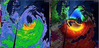
English: The last NEXRAD radar scans of Typhoon Mawar on PGUA. The left side shows NEXRAD reflectivity and the right side shows NEXRAD velocity. |
| 日期 | |
| 來源 | NEXRAD - PGUA |
| 作者 | National Weather Service |
授權條款
This image is in the public domain because it is from one or more of the U.S. government’s 159 NEXRAD radars, which are jointly owned and operated by the National Weather Service (NWS), an agency of the National Oceanic and Atmospheric Administration (NOAA) within the United States Department of Commerce, the Federal Aviation Administration (FAA) within the Department of Transportation, and the U.S. Air Force within the Department of Defense.
Thus all NEXRAD images are public domain.
|
  |
檔案歷史
點選日期/時間以檢視該時間的檔案版本。
| 日期/時間 | 縮圖 | 尺寸 | 用戶 | 備註 | |
|---|---|---|---|---|---|
| 目前 | 2023年5月24日 (三) 04:20 | | 1,920 × 943(580 KB) | WeatherWriter | Uploaded a work by National Weather Service from NEXRAD - PGUA with UploadWizard |
檔案用途
下列頁面有用到此檔案:
全域檔案使用狀況
以下其他 wiki 使用了這個檔案:
- en.wikipedia.org 的使用狀況
- pt.wikipedia.org 的使用狀況
- pt.wikinews.org 的使用狀況