
File:LocationKingdomAraucania.svg

此 SVG 檔案的 PNG 預覽的大小:800 × 400 像素。 其他解析度:320 × 160 像素 | 640 × 320 像素 | 1,024 × 512 像素 | 1,280 × 640 像素 | 2,560 × 1,280 像素 | 1,000 × 500 像素。
原始檔案 (SVG 檔案,表面大小:1,000 × 500 像素,檔案大小:987 KB)
摘要
| 描述 |
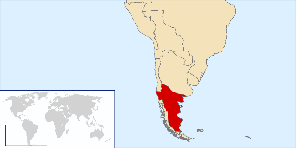
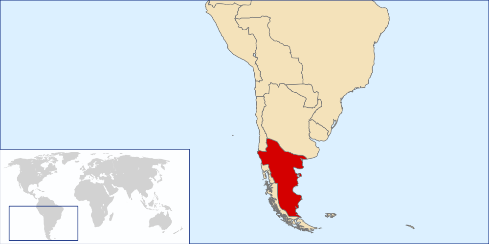
Español: Mapa localizador del Reino de la Araucanía y la Patagonia (1860-1862 aprox.).
Este mapa solo representa una idea básica de la localización del territorio reclamado por este estado no reconocido, puesto que no existe certeza exacta de las zonas reclamadas por el supuesto reino. Los mapas de otros países tampoco son representaciones fidedignas de sus fronteras en la época. La zona patagónica de Aisén, Magallanes y Tierra del Fuego aparece como un territorio distinto a Chile y Argentina al ser una zona reclamada por ambos países durante la época. La zona de la Patagonia Oriental, también reclamada por ambos, era cubierta por las reclamaciones del Reino de la Araucanía y la PatagoniaEnglish: Locator map of the Kingdom of Araucania and Patagonia (approx. 1860-1862).
The map shows only an idea of the territory disputed by the unrecognized Kingdom because there isn't any exact definition of it. Also the historical frontiers of other countries aren't accurate. The zone of Aysen, Magallanes and Tierra del Fuego islands are shown as a separate entity because it was disputed by Chile and Argentina at the time. Most of Western Patagonia (also disputed by both countries) are shown as a territory of the Kingdom. |
| 日期 | |
| 來源 | self-made based in Image:LocationChile.svg and Image:Continents.svg |
| 作者 | B1mbo |
授權條款
我,本作品的著作權持有者,決定用以下授權條款發佈本作品:

|
已授權您依據自由軟體基金會發行的無固定段落、封面文字和封底文字GNU自由文件授權條款1.2版或任意後續版本,對本檔進行複製、傳播和/或修改。該協議的副本列在GNU自由文件授權條款中。 |
This file is licensed under the Creative Commons Attribution-Share Alike 4.0 International, 3.0 Unported, 2.5 Generic, 2.0 Generic and 1.0 Generic license.
- 您可以自由:
- 分享 – 複製、發佈和傳播本作品
- 重新修改 – 創作演繹作品
- 惟需遵照下列條件:
- 姓名標示 – 您必須指名出正確的製作者,和提供授權條款的連結,以及表示是否有對內容上做出變更。您可以用任何合理的方式來行動,但不得以任何方式表明授權條款是對您許可或是由您所使用。
- 相同方式分享 – 如果您利用本素材進行再混合、轉換或創作,您必須基於如同原先的相同或兼容的條款,來分布您的貢獻成品。
您可以選擇您需要的授權條款。
檔案歷史
點選日期/時間以檢視該時間的檔案版本。
| 日期/時間 | 縮圖 | 尺寸 | 用戶 | 備註 | |
|---|---|---|---|---|---|
| 目前 | 2008年3月29日 (六) 02:50 | | 1,000 × 500(987 KB) | B1mbo | {{Information |Description={{es|Mapa localizador del Reino de la Araucanía y la Patagonia (1860-1862 aprox.). Este mapa solo representa una idea básica de la localización del territorio reclamado por este |
檔案用途
下列頁面有用到此檔案:
全域檔案使用狀況
以下其他 wiki 使用了這個檔案:
- ar.wikipedia.org 的使用狀況
- br.wikipedia.org 的使用狀況
- ca.wikipedia.org 的使用狀況
- en.wikipedia.org 的使用狀況
- es.wikipedia.org 的使用狀況
- fi.wikipedia.org 的使用狀況
- fr.wikipedia.org 的使用狀況
- ga.wikipedia.org 的使用狀況
- gl.wikipedia.org 的使用狀況
- he.wikipedia.org 的使用狀況
- id.wikipedia.org 的使用狀況
- it.wikipedia.org 的使用狀況
- ja.wikipedia.org 的使用狀況
- ko.wikipedia.org 的使用狀況
- nl.wikipedia.org 的使用狀況
- pt.wikipedia.org 的使用狀況
- sv.wikipedia.org 的使用狀況
- th.wikipedia.org 的使用狀況
- www.wikidata.org 的使用狀況