
File:MT-Nishi Biwajima Station-Aerial photography 1946.jpg

預覽大小:749 × 599 像素。 其他解析度:300 × 240 像素 | 600 × 480 像素 | 821 × 657 像素。
原始檔案 (821 × 657 像素,檔案大小:483 KB,MIME 類型:image/jpeg)
摘要
| 描述 |
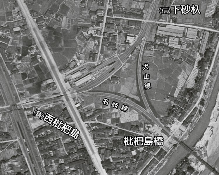
English: Nagoya Railroad Biwajimabashi Station and Nishi Biwajima Station. 日本語: 名古屋鉄道 枇杷島橋駅および西枇杷島駅 |
| 日期 | |
| 來源 |
|
| 作者 |
授權條款

|
本檔案的著作權持有者,Ministry of Land, Infrastructure, Transport and Tourism,在註明所有人姓名的前提下,允許任何人使用本檔案於任何用途。包含再散布、衍生作品、商業用途及其他用途。 |
姓名標示:
National Land Image Information (Color Aerial Photographs), created by Ministry of Land, Infrastructure, Transport and Tourism, distributed by Geospatial Information Authority of Japan
|

檔案歷史
點選日期/時間以檢視該時間的檔案版本。
| 日期/時間 | 縮圖 | 尺寸 | 用戶 | 備註 | |
|---|---|---|---|---|---|
| 目前 | 2020年10月3日 (六) 16:10 | | 821 × 657(483 KB) | ButuCC | {{Information |description={{en|1=Nagoya Railroad Biwajimabashi Station and Nishi Biwajima Station.}}{{ja|1=名古屋鉄道 枇杷島橋駅および西枇杷島駅}} |date=1946-05-28 |source= *国土交通省「国土画像情報(カラー空中写真)」(配布元:国土地理院地図・空中写真閲覧サービス) **[https://mapps.gsi.go.jp/maplibSearch.do?specificationId=1170597 整理番号 USA M148-A-7-184] |author={{ja|国土地理院、ButuCCが加工。}} {{en|Geospatial Information Authority of Japan, modified by ButuCC}} |perm... |
檔案用途
下列頁面有用到此檔案:
全域檔案使用狀況
以下其他 wiki 使用了這個檔案:
- ja.wikipedia.org 的使用狀況