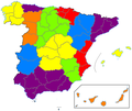
File:Map Spain 1833.png
外觀
Map_Spain_1833.png (467 × 394 像素,檔案大小:17 KB,MIME 類型:image/png)
檔案歷史
點選日期/時間以檢視該時間的檔案版本。
| 日期/時間 | 縮圖 | 尺寸 | 用戶 | 備註 | |
|---|---|---|---|---|---|
| 目前 | 2010年2月1日 (一) 00:36 |  | 467 × 394(17 KB) | Javitomad | Aranjuez was in Toledo province in 1833 |
| 2010年2月1日 (一) 00:29 |  | 467 × 394(17 KB) | Javitomad | {{User:Javitomad/credit}} == {{int:filedesc}} == {{Information {{Information |Description= {{en|Map of the Spanish divisions in 1833.}} {{es|Mapa de la división territorial de España de 1833.}} |Source= {{en|own work}} {{es|t | |
| 2010年1月3日 (日) 01:03 |  | 256 × 233(6 KB) | Jmabel | Try again: Restore Enclave of Treviño; distinguish Navarra from the other Basque provinces | |
| 2010年1月3日 (日) 01:02 |  | 256 × 233(8 KB) | Jmabel | Reverted to version as of 01:23, 7 January 2007. Not sure why my recent upload didn't work but trying again. | |
| 2010年1月3日 (日) 00:59 |  | 256 × 233(6 KB) | Jmabel | Restore Enclave of Treviño; distinguish Navarra from the other Basque provinces | |
| 2007年1月7日 (日) 01:23 |  | 256 × 233(8 KB) | Jmadrid | {{Information |Description=Mapa de la división territorial de España de 1833|Map of the Spanish divisions in 1833. |Source=Desconocida|Unknown |Date=21-XII-2006|12.21.2006 |Author=Javitomad |Permission=libre|free. }} | |
| 2006年12月21日 (四) 17:50 |  | 256 × 233(6 KB) | Jmadrid | {{Information |Description=Mapa de la división territorial de España de 1833|Map of the Spanish divisions in 1833. |Source=Desconocida|Unknown |Date=21-XII-2006|12.21.2006 |Author=Javitomad |Permission=libre|free. }} |
檔案用途
沒有使用此檔案的頁面。
全域檔案使用狀況
以下其他 wiki 使用了這個檔案:
- en.wikipedia.org 的使用狀況
- es.wikipedia.org 的使用狀況
- fr.wikipedia.org 的使用狀況


