
File:Mars Crustal Magnetism MGS.png

預覽大小:800 × 549 像素。 其他解析度:320 × 219 像素 | 640 × 439 像素 | 1,024 × 702 像素 | 1,280 × 878 像素 | 1,524 × 1,045 像素。
原始檔案 (1,524 × 1,045 像素,檔案大小:1.44 MB,MIME 類型:image/png)
摘要
| 描述 |
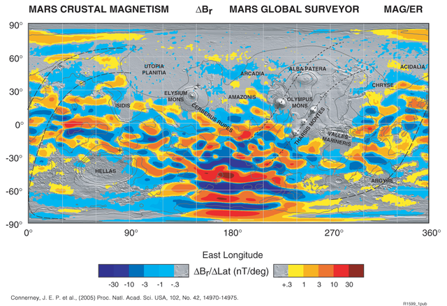
English: The global map is built up from many thousands of orbits at constant altitude (mapping orbit), and uses colors to represent the strength and direction of the field caused by crustal magnetization.
It's originally in TIFF format. I transformed it into PNG format by Photoshop 7.0.1 to make it visible on the net. |
| 日期 | |
| 來源 | http://www.nasa.gov/centers/goddard/news/topstory/2005/mgs_plates.html |
| 作者 | NASA |
授權條款
| 本作品由NASA創作,屬於公有領域。根據NASA的版權政策:“NASA的創作除非另有聲明否則不受版權保護。”(參見:Template:PD-USGov/zh,NASA版權政策或JPL圖像使用政策) | ||
 |
警告:
|
檔案歷史
點選日期/時間以檢視該時間的檔案版本。
| 日期/時間 | 縮圖 | 尺寸 | 用戶 | 備註 | |
|---|---|---|---|---|---|
| 目前 | 2009年5月28日 (四) 05:20 | | 1,524 × 1,045(1.44 MB) | Areong | {{Information |Description={{en|1=The global map is built up from many thousands of orbits at constant altitude (mapping orbit), and uses colors to represent the strength and direction of the field caused by crustal magnetization. It's originally in TIF |
檔案用途
全域檔案使用狀況
以下其他 wiki 使用了這個檔案:
- be.wikipedia.org 的使用狀況
- en.wikipedia.org 的使用狀況
- fr.wikipedia.org 的使用狀況
- fr.wikibooks.org 的使用狀況
- hy.wikipedia.org 的使用狀況
- nl.wikipedia.org 的使用狀況
- pt.wikipedia.org 的使用狀況
- ru.wikipedia.org 的使用狀況
- uk.wikipedia.org 的使用狀況