
File:NUTS 3 regions of Scotland map.svg

此 SVG 檔案的 PNG 預覽的大小:456 × 600 像素。 其他解析度:182 × 240 像素 | 365 × 480 像素 | 584 × 768 像素 | 779 × 1,024 像素 | 1,558 × 2,048 像素 | 1,023 × 1,345 像素。
原始檔案 (SVG 檔案,表面大小:1,023 × 1,345 像素,檔案大小:2.92 MB)
摘要
| 描述 | |
| 日期 | (UTC) |
| 來源 |
本檔案衍生自: |
| 作者 |
|
| 其他版本 | File:NUTS 3 regions of central and southern Scotland map.svg shows an enlargement of the southern part of this map. |


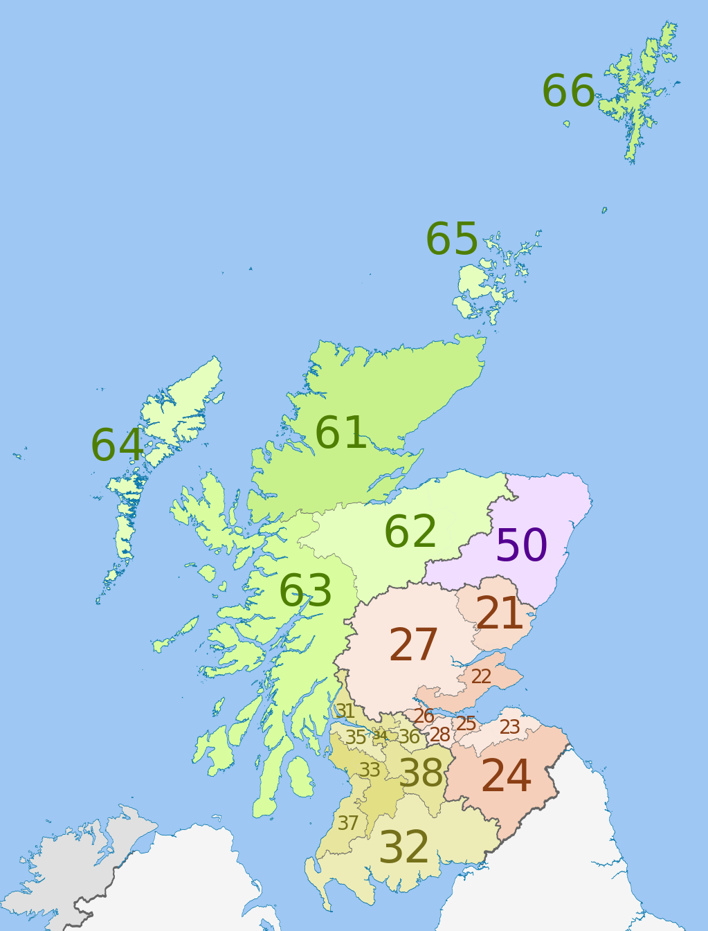
| NUTS 1 | Code | NUTS 2 | Code | NUTS 3 | Code |
|---|---|---|---|---|---|
| Scotland | UKM | Eastern Scotland | UKM2 | Angus and Dundee | UKM21 |
| Clackmannanshire and Fife | UKM22 | ||||
| East Lothian and Midlothian | UKM23 | ||||
| Scottish Borders | UKM24 | ||||
| Edinburgh | UKM25 | ||||
| Falkirk | UKM26 | ||||
| Perth and Kinross, and Stirling | UKM27 | ||||
| West Lothian | UKM28 | ||||
| South Western Scotland | UKM3 | East Dunbartonshire, West Dunbartonshire, and Helensburgh and Lomond | UKM31 | ||
| Dumfries and Galloway | UKM32 | ||||
| East and North Ayrshire mainland | UKM33 | ||||
| Glasgow | UKM34 | ||||
| Inverclyde, East Renfrewshire, and Renfrewshire | UKM35 | ||||
| North Lanarkshire | UKM36 | ||||
| South Ayrshire | UKM37 | ||||
| South Lanarkshire | UKM38 | ||||
| North Eastern Scotland | UKM5 | Aberdeen and Aberdeenshire | UKM50 | ||
| Highlands and Islands | UKM6 | Caithness and Sutherland, and Ross and Cromarty | UKM61 | ||
| Inverness, Nairn, Moray, and Badenoch and Strathspey | UKM62 | ||||
| Lochaber, Skye and Lochalsh, Arran and Cumbrae, and Argyll and Bute (except Helensburgh and Lomond) | UKM63 | ||||
| Eilean Siar (Western Isles) | UKM64 | ||||
| Orkney Islands | UKM65 | ||||
| Shetland Islands | UKM66 |
授權條款
此檔案採用共享創意 姓名標示-相同方式分享 3.0 未在地化版本授權條款。
姓名標示: Dr Greg, Nilfanion & XrysD. Contains Ordnance Survey data © Crown copyright and database right 2011
- 您可以自由:
- 分享 – 複製、發佈和傳播本作品
- 重新修改 – 創作演繹作品
- 惟需遵照下列條件:
- 姓名標示 – 您必須指名出正確的製作者,和提供授權條款的連結,以及表示是否有對內容上做出變更。您可以用任何合理的方式來行動,但不得以任何方式表明授權條款是對您許可或是由您所使用。
- 相同方式分享 – 如果您利用本素材進行再混合、轉換或創作,您必須基於如同原先的相同或兼容的條款,來分布您的貢獻成品。
原始上傳日誌
This image is a derivative work of the following images:
- File:Scottish_council_areas_2011.svg licensed with Cc-by-sa-3.0
- 2011-05-01T19:21:40Z Nilfanion 1023x1345 (3008417 Bytes) {{Information |Description=Map showing the [[w:Council areas of Scotland|Council areas of Scotland]] in 2011. Equirectangular map projection on WGS 84 datum, with N/S stretched 170% Geographic limits: *West: 8.8W *East: 0.4
- File:Scotland_Administrative_Map_1947.png licensed with Cc-by-sa-3.0-migrated, FAL, GFDL
- 2009-06-14T12:39:08Z XrysD 2000x3479 (2679270 Bytes) Corrected typo
- 2009-06-14T12:04:54Z XrysD 2000x3479 (2679081 Bytes) {{Information |Description={{en|1=Administrative map of Scotland in 1947. Showing Counties and Districts, Counties of Cities, Large and Smal Burghs}} |Source=Own work by uploader |Author=[[User:XrysD|XrysD]] |Date=2009-06-14
Uploaded with derivativeFX
檔案歷史
點選日期/時間以檢視該時間的檔案版本。
| 日期/時間 | 縮圖 | 尺寸 | 用戶 | 備註 | |
|---|---|---|---|---|---|
| 目前 | 2012年6月5日 (二) 00:46 | | 1,023 × 1,345(2.92 MB) | Dr Greg | == {{int:filedesc}} == {{Information |Description={{en|Map of the NUTS 3 regions of en:Scotland in 2011. Equirectangular map projection on WGS 84 datum, with N/S stretched 170% Geograph... |
檔案用途
下列頁面有用到此檔案:
全域檔案使用狀況
以下其他 wiki 使用了這個檔案:
- ar.wikipedia.org 的使用狀況
- de.wikipedia.org 的使用狀況
- en.wikipedia.org 的使用狀況
- fi.wikipedia.org 的使用狀況
- it.wikipedia.org 的使用狀況
- lt.wikipedia.org 的使用狀況
- ru.wikipedia.org 的使用狀況
- uk.wikipedia.org 的使用狀況