
File:NUTS 3 regions of Wales map.svg

此 SVG 檔案的 PNG 預覽的大小:501 × 599 像素。 其他解析度:201 × 240 像素 | 401 × 480 像素 | 642 × 768 像素 | 856 × 1,024 像素 | 1,713 × 2,048 像素 | 1,047 × 1,252 像素。
原始檔案 (SVG 檔案,表面大小:1,047 × 1,252 像素,檔案大小:325 KB)
摘要
| 描述 |
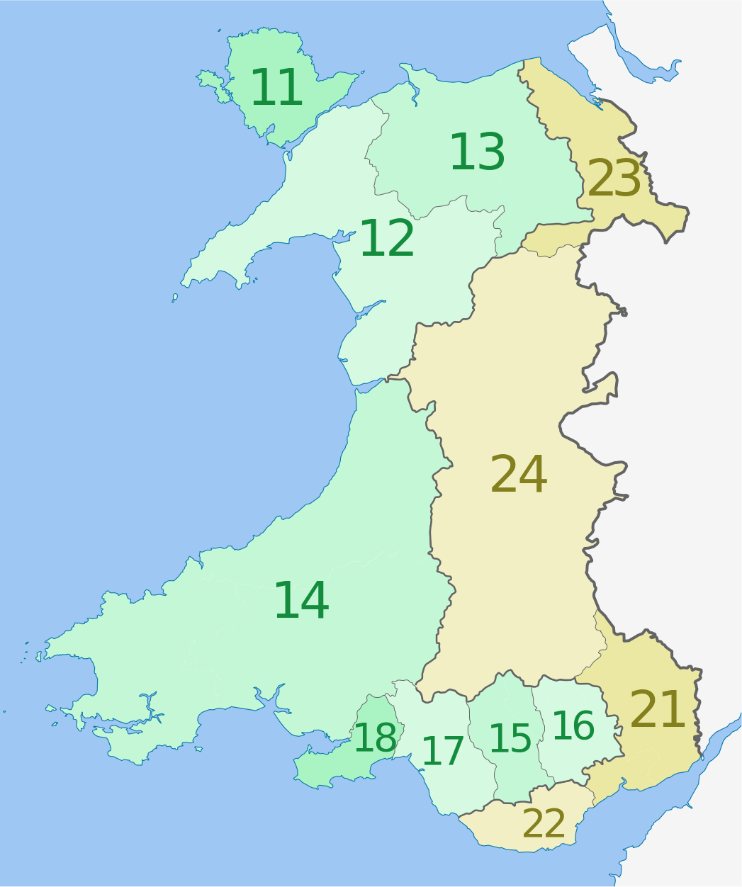
Deutsch: Karte von Wales, Vereinigtes Königreich: NUTS-Raumeinheiten auf den Ebenen NUTS3.
Quadratische Plattkarte, N-S-Streckung 163 %. Geographische Begrenzung der Karte:
English: Map of the NUTS 3 regions of Wales, United Kingdom.
Equirectangular projection, N/S stretching 163 %. Geographic limits of the map:
|
| 日期 | (UTC) |
| 來源 |
本檔案衍生自: Wales location map.svg:  |
| 作者 |
|
| NUTS 1 | Code | NUTS 2 | Code | NUTS 3 | Code |
|---|---|---|---|---|---|
| Wales | UKL | West Wales and The Valleys | UKL1 | Isle of Anglesey | UKL11 |
| Gwynedd | UKL12 | ||||
| Conwy and Denbighshire | UKL13 | ||||
| South West Wales (Ceredigion, Carmarthenshire, Pembrokeshire) | UKL14 | ||||
| Central Valleys (Merthyr Tydfil, Rhondda Cynon Taff) | UKL15 | ||||
| Gwent Valleys (Blaenau Gwent, Caerphilly, Torfaen) | UKL16 | ||||
| Bridgend and Neath Port Talbot | UKL17 | ||||
| Swansea | UKL18 | ||||
| East Wales | UKL2 | Monmouthshire and Newport | UKL21 | ||
| Cardiff and Vale of Glamorgan | UKL22 | ||||
| Flintshire and Wrexham | UKL23 | ||||
| Powys | UKL24 |
授權條款
我,本作品的著作權持有者,決定用以下授權條款發佈本作品:
此檔案採用共享創意 姓名標示-相同方式分享 3.0 未在地化版本授權條款。
姓名標示: Dr Greg and NordNordWest
- 您可以自由:
- 分享 – 複製、發佈和傳播本作品
- 重新修改 – 創作演繹作品
- 惟需遵照下列條件:
- 姓名標示 – 您必須指名出正確的製作者,和提供授權條款的連結,以及表示是否有對內容上做出變更。您可以用任何合理的方式來行動,但不得以任何方式表明授權條款是對您許可或是由您所使用。
- 相同方式分享 – 如果您利用本素材進行再混合、轉換或創作,您必須基於如同原先的相同或兼容的條款,來分布您的貢獻成品。
原始上傳日誌
This image is a derivative work of the following images:
- File:Wales_location_map.svg licensed with Cc-by-sa-3.0
- 2009-06-24T13:27:54Z NordNordWest 1047x1252 (242334 Bytes) {{Information |Description= {{de|Positionskarte von [[:de:Wales|Wales]], [[:de:Vereinigtes Königreich|Vereinigtes Königreich]]}} Quadratische Plattkarte, N-S-Streckung 163 %. Geographische Begrenzung der Karte: * N: 53.5°
Uploaded with derivativeFX
檔案歷史
點選日期/時間以檢視該時間的檔案版本。
| 日期/時間 | 縮圖 | 尺寸 | 用戶 | 備註 | |
|---|---|---|---|---|---|
| 目前 | 2012年8月1日 (三) 02:30 | | 1,047 × 1,252(325 KB) | Dr Greg | corrected labelling error (23 & 24 transposed) |
| 2012年6月5日 (二) 01:10 |  | 1,047 × 1,252(325 KB) | Dr Greg | == {{int:filedesc}} == {{Information |Description={{de|Karte von Wales, Vereinigtes Königreich: NUTS-Raumeinheiten auf den Ebenen NUTS3. Quadratische Plattkarte, N-S-Streckung 163 %. Geogr... |
檔案用途
下列頁面有用到此檔案:
全域檔案使用狀況
以下其他 wiki 使用了這個檔案:
- ar.wikipedia.org 的使用狀況
- cy.wikipedia.org 的使用狀況
- de.wikipedia.org 的使用狀況
- en.wikipedia.org 的使用狀況
- fi.wikipedia.org 的使用狀況
- it.wikipedia.org 的使用狀況
- lt.wikipedia.org 的使用狀況
- ru.wikipedia.org 的使用狀況
- uk.wikipedia.org 的使用狀況