
File:North West England districts 2011 map.svg

此 SVG 檔案的 PNG 預覽的大小:300 × 599 像素。 其他解析度:120 × 240 像素 | 240 × 480 像素 | 385 × 768 像素 | 513 × 1,024 像素 | 1,026 × 2,048 像素 | 674 × 1,345 像素。
原始檔案 (SVG 檔案,表面大小:674 × 1,345 像素,檔案大小:1.34 MB)
摘要
| 描述 |
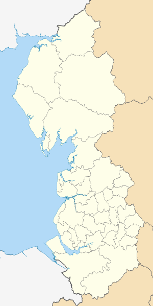
Map of the North West England region showing the administrative districts. Equirectangular map projection on WGS 84 datum, with N/S stretched 170% Geographic limits:
|
| 日期 | |
| 來源 |
|
| 作者 | Nilfanion, created using Ordnance Survey data |
| 其他版本 |
Derivative works of this file: |
授權條款
我,本作品的著作權持有者,決定用以下授權條款發佈本作品:
此檔案採用共享創意 姓名標示-相同方式分享 3.0 未在地化版本授權條款。
- 您可以自由:
- 分享 – 複製、發佈和傳播本作品
- 重新修改 – 創作演繹作品
- 惟需遵照下列條件:
- 姓名標示 – 您必須指名出正確的製作者,和提供授權條款的連結,以及表示是否有對內容上做出變更。您可以用任何合理的方式來行動,但不得以任何方式表明授權條款是對您許可或是由您所使用。
- 相同方式分享 – 如果您利用本素材進行再混合、轉換或創作,您必須基於如同原先的相同或兼容的條款,來分布您的貢獻成品。

|
已授權您依據自由軟體基金會發行的無固定段落、封面文字和封底文字GNU自由文件授權條款1.2版或任意後續版本,對本檔進行複製、傳播和/或修改。該協議的副本列在GNU自由文件授權條款中。 |
您可以選擇您需要的授權條款。
檔案歷史
點選日期/時間以檢視該時間的檔案版本。
| 日期/時間 | 縮圖 | 尺寸 | 用戶 | 備註 | |
|---|---|---|---|---|---|
| 目前 | 2011年5月1日 (日) 19:03 | | 674 × 1,345(1.34 MB) | Nilfanion | == Summary == {{Information |Description=Map of the North West England region showing the administrative districts. Equirectangular map projection on WGS 84 datum, with N/S stretched 170% Geographic limits: *West: 3.8W *East: 1. |
檔案用途
沒有使用此檔案的頁面。
全域檔案使用狀況
以下其他 wiki 使用了這個檔案:
- ar.wikipedia.org 的使用狀況
- ceb.wikipedia.org 的使用狀況
- el.wikipedia.org 的使用狀況
- en.wikipedia.org 的使用狀況
- Cheshire
- Liverpool
- Manchester
- Lancashire
- North West England
- Cumbria
- Greater Manchester
- Metropolitan Borough of Rochdale
- Merseyside
- Tameside
- Metropolitan Borough of Knowsley
- Metropolitan Borough of Wirral
- Trafford
- Metropolitan Borough of Sefton
- Southport
- Blackburn with Darwen
- Borough of Halton
- Birkdale
- West Lancashire
- South Ribble
- Borough of Fylde
- Borough of Wyre
- Ribble Valley
- Borough of Rossendale
- Hyndburn
- Template:NW England
- City of Lancaster
- Borough of Chorley
- Metropolitan Borough of Wigan
- Metropolitan Borough of Bolton
- City of Salford
- Metropolitan Borough of Bury
- Metropolitan Borough of Oldham
- Borough of Burnley
- Metropolitan Borough of St Helens
- St Helens, Merseyside
- Lunt
- Winter Hill transmitting station
- Metropolitan Borough of Stockport
- User:Phildav76/Regional templates
- User:Pixie2000/Sand1
- Turton, Lancashire
- Cheshire East
- Cheshire West and Chester
- Wikipedia:WikiProject Countries/Templates/Navboxes/European country subdivisions
- Manchester Academy of Fine Arts
- Liverpool Maritime Mercantile City
檢視此檔案的更多全域使用狀況。