
File:PIA00215-cropped.jpg
預覽大小:766 × 599 像素。 其他解析度:307 × 240 像素 | 614 × 480 像素 | 869 × 680 像素。
原始檔案 (869 × 680 像素,檔案大小:206 KB,MIME 類型:image/jpeg)
摘要
| 描述 |
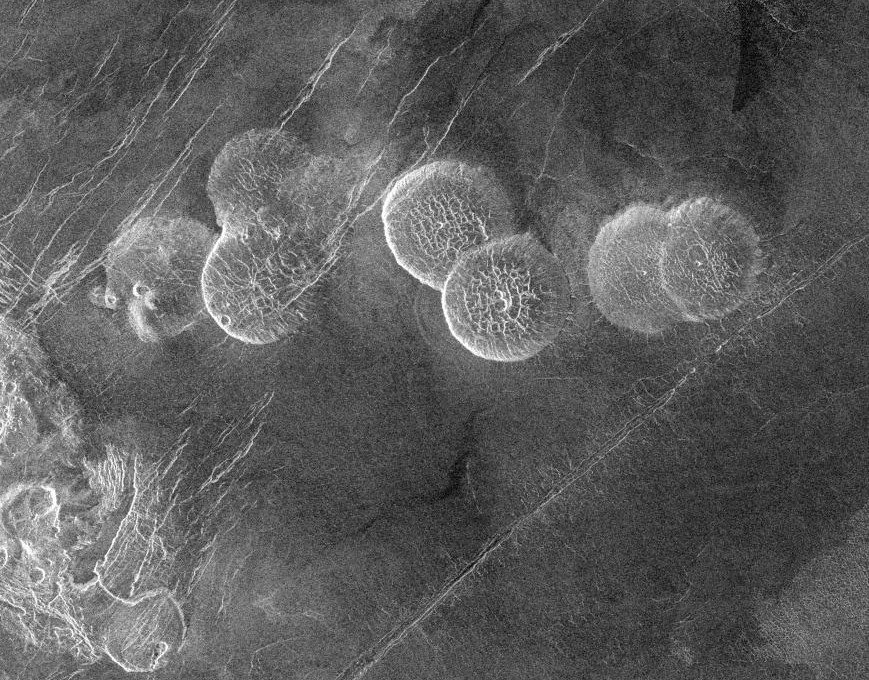
English: The eastern edge of Alpha Regio is shown in this image centered at 30 degrees south latitude and 11.8 degrees east longitude (longitude on Venus is measured from 0 degrees to 360 degrees east). Seven circular, dome-like hills, averaging 25 kilometers (15 miles) in diameter with maximum heights of 750 meters (2,475 feet) dominate the scene. These features are interpreted as very thick lava flows that came from an opening on the relatively level ground, which allowed the lava to flow in an even pattern outward from the opening. The complex fractures on top of the domes suggest that if the domes were created by lava flows, a cooled outer layer formed and then further lava flowing in the interior stretched the surface. The domes may be similar to volcanic domes on Earth. Another interpretation is that the domes are the result of molten rock or magma in the interior that pushed the surface layer upward. The near-surface magma then withdrew to deeper levels, causing the collapse and fracturing of the dome surface. The bright margins possibly indicate the presence of rock debris on the slopes of the domes. Some of the fractures on the plains cut through the domes, while others appear to be covered by the domes. This indicates that active processes pre date and post date the dome-like hills. The prominent black area in the northeast corner of the image is a data gap. North is at the top of the image. Mosaic of Magellan radar images. The domes are called Seoritsu Farra (a map) |
| 日期 | |
| 來源 | http://photojournal.jpl.nasa.gov/catalog/PIA00215 |
| 作者 | NASA/JPL |
| 其他版本 | file:Alpha Regio.jpg |
| 此標籤不表示文件的著作權狀態。任何文件在附有此標籤的同時還需要一個有效的著作權標籤。請參閱許可協議說明頁面以了解更多資訊。 其他語言:
|
| 本作品由NASA創作,屬於公有領域。根據NASA的版權政策:“NASA的創作除非另有聲明否則不受版權保護。”(參見:Template:PD-USGov/zh,NASA版權政策或JPL圖像使用政策) | ||
 |
警告:
|
檔案歷史
點選日期/時間以檢視該時間的檔案版本。
| 日期/時間 | 縮圖 | 尺寸 | 用戶 | 備註 | |
|---|---|---|---|---|---|
| 目前 | 2005年11月27日 (日) 19:20 | | 869 × 680(206 KB) | Dodo | PIA00215: Venus - Alpha Regio The eastern edge of Alpha Regio is shown in this image centered at 30 degrees south latitude and 11.8 degrees east longitude (longitude on Venus is measured from 0 degrees to 360 degrees east). Seven circular, dome-like hill |
檔案用途
下列頁面有用到此檔案:
全域檔案使用狀況
以下其他 wiki 使用了這個檔案:
- bat-smg.wikipedia.org 的使用狀況
- ca.wikipedia.org 的使用狀況
- de.wikipedia.org 的使用狀況
- en.wikipedia.org 的使用狀況
- es.wikipedia.org 的使用狀況
- eu.wikipedia.org 的使用狀況
- fr.wikipedia.org 的使用狀況
- ja.wikipedia.org 的使用狀況
- lt.wikipedia.org 的使用狀況
- nds.wikipedia.org 的使用狀況
- nn.wikipedia.org 的使用狀況
- no.wikipedia.org 的使用狀況
- pt.wikipedia.org 的使用狀況
- sk.wikipedia.org 的使用狀況