
File:Persia 600ad.jpg
原始檔案 (1,098 × 623 像素,檔案大小:644 KB,MIME 類型:image/jpeg)
Rest

|
本圖片是以PNG、GIF或JPEG格式上傳。然而,其中包含的資料或訊息,應該重新建立成可縮放向量圖形(SVG)檔案,以更有效率或更準確的方式儲存。如有可能,請上傳本圖片的SVG格式版本。在上傳之後,請修改維基各姊妹計畫中所有使用舊版圖片的條目(列在圖像連結章節中),替換為新版圖片,並在舊圖片的描述頁中加入{{Vector version available|新圖片名稱.svg}}模板,同時移除本模板。
|


摘要
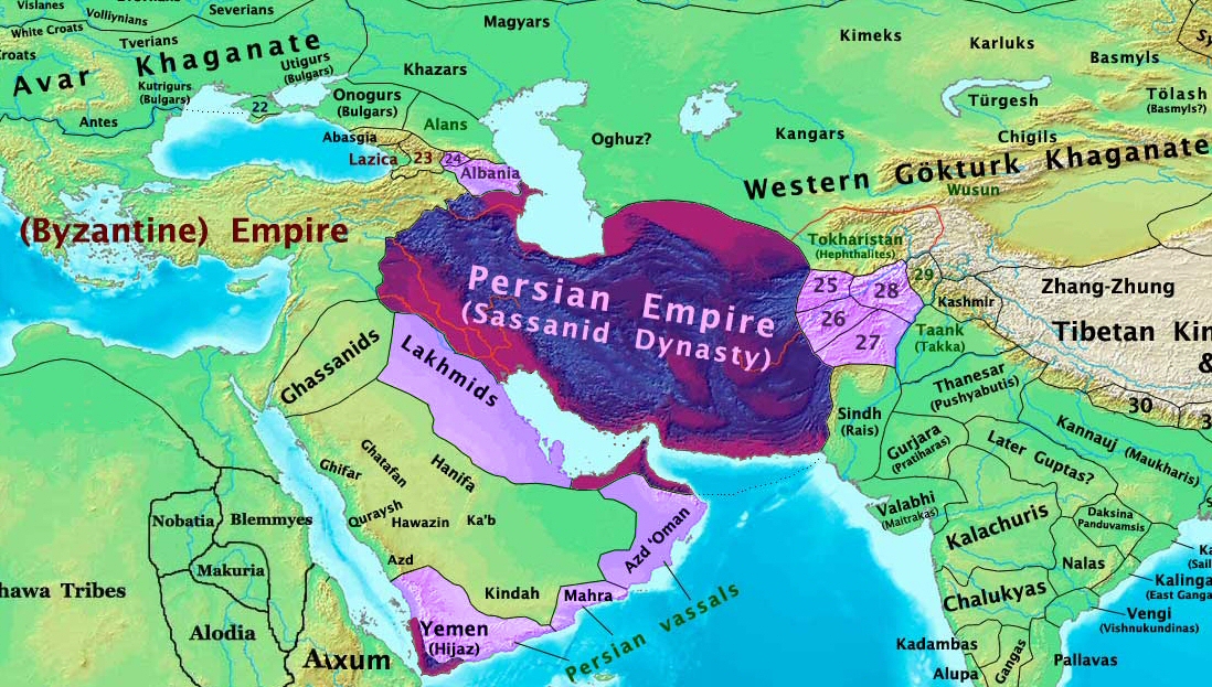
| 描述 | The Persian Sassanid Empire in 600 AD. |
| 日期 | |
| 來源 | 自己的作品 |
| 作者 | Thomas Lessman (Contact!) |
| 授權許可 (重用此檔案) |
我,本作品的著作權持有者,決定用以下授權條款發佈本作品: 此檔案採用共享創意 姓名標示-相同方式分享 3.0 未在地化版本授權條款。
|
| 其他版本 | see below |
Map Summary

Original Source URL: http://www.thomaslessman.com/History/images/East-Hem_600ad.jpg
This map is a zoomed-in version of Thomas Lessman's map of the
East-Hem_600ad.jpg (also available at www.WorldHistoryMaps.info).
The highlighted areas represent the Persian Sassanid Empire and its territories in the year 600 AD (before the Great Romano-Persian war).
Map Source References
Remember, sources often conflict with each other. This map is only as accurate as the information that is available to me. To report any errors or to help further this work, please click here, or email Thomas Lessman at talessman@yis.us
References for information contained in this map:
Other Maps by Thomas Lessman
| Maps of the eastern hemisphere showing history
Bold dates are available on Wikimedia or Wikipedia. | ||
| Primeval | ||
| Ancient
|
·| 600 BC | 550 BC | 527 BC | 500 BC |
400 BC | ·| 1 AD | 50 AD | 100 AD | 200 AD | 300 AD | | |
| Medieval |
·| 500 AD | 565 AD | 600 AD | 700 AD | | |
| Modern |
·| 1500 AD | · * For historical maps of the whole world, | |
Other Info
原始上傳日誌
- 2008-01-30 00:27 Talessman 1724×814×8 (267093 bytes) This image is a zoomed-in version of [http://en.wikipedia.org/wiki/Image:East-Hem_600ad.jpg Eastern Hemisphere in 600 AD]. The highlighted area is the Persian Sassanid Empire. [[Image:East-Hem_600ad.jpg|thumb|300px|left|Eastern Hemisphere in 600 AD.]] Author: T
檔案歷史
點選日期/時間以檢視該時間的檔案版本。
| 日期/時間 | 縮圖 | 尺寸 | 用戶 | 備註 | |
|---|---|---|---|---|---|
| 目前 | 2015年12月7日 (一) 19:44 | | 1,098 × 623(644 KB) | B | Removed obnoxious label |
| 2008年8月21日 (四) 21:00 |  | 1,098 × 623(813 KB) | Talessman | Updated version of the parent map. This new version features colored areas to highlight the Persian Empire and its vassal states. | |
| 2008年4月28日 (一) 17:25 |  | 1,724 × 814(261 KB) | Producer | {{Information |Description={{en|This image is a zoomed-in version of [http://en.wikipedia.org/wiki/Image:East-Hem_600ad.jpg Eastern Hemisphere in 600 AD]. The highlighted area is the Sassanid Persian Empire. [[:en:Image:East-Hem_600ad.jpg|thumb|300px|lef |
檔案用途
下列4個頁面有用到此檔案:
全域檔案使用狀況
以下其他 wiki 使用了這個檔案:
- ar.wikipedia.org 的使用狀況
- as.wikipedia.org 的使用狀況
- azb.wikipedia.org 的使用狀況
- bn.wikipedia.org 的使用狀況
- ca.wikipedia.org 的使用狀況
- cs.wikipedia.org 的使用狀況
- de.wikipedia.org 的使用狀況
- el.wikipedia.org 的使用狀況
- en.wikipedia.org 的使用狀況
- es.wikipedia.org 的使用狀況
- fa.wikipedia.org 的使用狀況
- fr.wikipedia.org 的使用狀況
- hi.wikipedia.org 的使用狀況
- hy.wikipedia.org 的使用狀況
- hyw.wikipedia.org 的使用狀況
- id.wikipedia.org 的使用狀況
- incubator.wikimedia.org 的使用狀況
- is.wikipedia.org 的使用狀況
- it.wikipedia.org 的使用狀況
- ja.wikipedia.org 的使用狀況
- ka.wikipedia.org 的使用狀況
檢視此檔案的更多全域使用狀況。