跳至內容

File:Sanriku-Erdbeben.jpg

頁面內容不支援其他語言。
這個檔案來自維基共享資源
維基百科,自由的百科全書

原始檔案 (796 × 858 像素,檔案大小:161 KB,MIME 類型:image/jpeg


摘要

描述
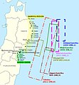
English: Historical tsunamis in the Sanriku area and selection of areas affected by the 2011 Tōhoku tsunami. (Source: Anawat Suppasri, Nobuo Shuto, Fumihiko Imamura, Shunichi Koshimura, Erick Mas, Ahmet Cevdet Yalciner: "Lessons Learned from the 2011 Great East Japan Tsunami: Performance of Tsunami Countermeasures, Coastal Buildings, and Tsunami Evacuation in Japan", Pure and Applied Geophysics, 170, (6-8), 2013, p. 993–1018, here p. 994, figure 1, DOI=10.1007/s00024-012-0511-7, online published: 7. July 2012. Modified and combined with: Nobuhito Mori, Daniel T. Cox, Tomohiro Yasuda, Hajime Mase: "Overview of the 2011 Tohoku Earthquake Tsunami Damage and Its Relation to Coastal Protection along the Sanriku Coast", Earthquake Spectra, 29 (S1), 2013, pp. 127-143, DOI=10.1193/1.4000118, here p. 131, fig. 3. And combined with: Tadashi Nakasu, Yuichi Ono, Wiraporn Pothisiri: "Why did Rikuzentakata have a high death toll in the 2011 Great East Japan Earthquake and Tsunami disaster? Finding the devastating disaster’s root causes", International Journal of Disaster Risk Reduction, Band=27, March 2018, pp. 21-36, DOI: 10.1016/j.ijdrr.2017.08.001, online published on 15 August 2017, here p. 23, fig. 1. Cf. Akemi Ishigaki, Hikari Higashi, Takako Sakamoto, Shigeki Shibahara: "The Great East-Japan Earthquake and Devastating Tsunami: An Update and Lessons from the Past Great Earthquakes in Japan since 1923", The Tohoku Journal of Experimental Medicine, 229, 4, 2013, pp. 287-299, DOI:10.1620/tjem.229.287, online published on 13 April 2013, here: p. 289, Fig. 1 "Distribution of the epicenters of the three Great Earthquakes."
Deutsch: Historische Tsunamis in der Sanriku-Region und Auswahl von Gebieten, die vom Tōhoku-Tsunami von 2011 betroffen waren. (Quelle: Anawat Suppasri, Nobuo Shuto, Fumihiko Imamura, Shunichi Koshimura, Erick Mas, Ahmet Cevdet Yalciner: "Lessons Learned from the 2011 Great East Japan Tsunami: Performance of Tsunami Countermeasures, Coastal Buildings, and Tsunami Evacuation in Japan", Pure and Applied Geophysics, 170, (6-8), 2013, S. 993–1018, hier S. 994, Abb. 1, DOI=10.1007/s00024-012-0511-7, online veröffentlicht am: 7. Juli 2012.) Verändert und kombiniert mit: Nobuhito Mori, Daniel T. Cox, Tomohiro Yasuda, Hajime Mase: "Overview of the 2011 Tohoku Earthquake Tsunami Damage and Its Relation to Coastal Protection along the Sanriku Coast", Earthquake Spectra, 29 (S1), 2013, S. 127-143, DOI=10.1193/1.4000118, hier S. 131, Abb. 3. Und kombiniert mit: Tadashi Nakasu, Yuichi Ono, Wiraporn Pothisiri: "Why did Rikuzentakata have a high death toll in the 2011 Great East Japan Earthquake and Tsunami disaster? Finding the devastating disaster’s root causes", International Journal of Disaster Risk Reduction, Band=27, März 2018, S. 21-36, DOI: 10.1016/j.ijdrr.2017.08.001, online veröffentlicht am 15. August 2017, hier S. 23, Abb. 1
日期
來源 自己的作品; Original for content: Anawat Suppasri, Nobuo Shuto, Fumihiko Imamura, Shunichi Koshimura, Erick Mas, Ahmet Cevdet Yalciner: "Lessons Learned from the 2011 Great East Japan Tsunami: Performance of Tsunami Countermeasures, Coastal Buildings, and Tsunami Evacuation in Japan", Pure and Applied Geophysics, 170, (6-8), 2013, p. 993–1018, DOI=10.1007/s00024-012-0511-7, online published: 7. July 2012.
作者 Modification and map: Anglo-Araneophilus~commonswiki, Original for content: Anawat Suppasri, Nobuo Shuto, Fumihiko Imamura, Shunichi Koshimura, Erick Mas, Ahmet Cevdet Yalciner: "Lessons Learned from the 2011 Great East Japan Tsunami: Performance of Tsunami Countermeasures, Coastal Buildings, and Tsunami Evacuation in Japan", Pure and Applied Geophysics, 170, (6-8), 2013, p. 993–1018, DOI=10.1007/s00024-012-0511-7, online published: 7. July 2012.
授權許可
(重用此檔案)
w:zh:共享創意
姓名標示 相同方式分享
您可以自由:
  • 分享 – 複製、發佈和傳播本作品
  • 重新修改 – 創作演繹作品
惟需遵照下列條件:
  • 姓名標示 – 您必須指名出正確的製作者,和提供授權條款的連結,以及表示是否有對內容上做出變更。您可以用任何合理的方式來行動,但不得以任何方式表明授權條款是對您許可或是由您所使用。
  • 相同方式分享 – 如果您利用本素材進行再混合、轉換或創作,您必須基於如同原先的相同或兼容的條款,來分布您的貢獻成品。

說明

添加單行說明來描述出檔案所代表的內容

在此檔案描寫的項目

描繪內容

著作權狀態 繁體中文 (已轉換拼寫)

有著作權 繁體中文 (已轉換拼寫)

檔案來源 Chinese (Taiwan) (已轉換拼寫)

上傳者的原創作品 繁體中文 (已轉換拼寫)

檔案歷史

點選日期/時間以檢視該時間的檔案版本。

日期/時間縮⁠圖尺寸用戶備⁠註
目前2018年8月14日 (二) 19:09於 2018年8月14日 (二) 19:09 版本的縮圖796 × 858(161 KB)Anglo-Araneophilus~commonswikiModified and combined with: Anawat Suppasri,Yo Fukutani,Yoshi Abe,Fumihiko Imamura: "Relationship between earthquake magnitude and tsunami height along the Tohoku coast based on historical tsunami trace database and the 2011 Great East Japan Tsunami", Report of Tsunami Engineering, Vol. 30 (2013), pp. 37-49, here: Fig. 2 ("Location of tsunami affected areas and historical tsunami height distribution").
2018年4月6日 (五) 08:21於 2018年4月6日 (五) 08:21 版本的縮圖796 × 858(158 KB)Anglo-Araneophilus~commonswikiModified and combined with: Tadashi Nakasu, Yuichi Ono, Wiraporn Pothisiri: "Why did Rikuzentakata have a high death toll in the 2011 Great East Japan Earthquake and Tsunami disaster? Finding the devastating disaster’s root causes", International Journal of Disaster Risk Reduction, Band=27, March 2018, pp. 21-36, DOI: 10.1016/j.ijdrr.2017.08.001, online published on 15 August 2017.
2018年4月1日 (日) 19:33於 2018年4月1日 (日) 19:33 版本的縮圖796 × 858(150 KB)Anglo-Araneophilus~commonswikiModified and combined with: Nobuhito Mori, Daniel T. Cox, Tomohiro Yasuda, Hajime Mase: "Overview of the 2011 Tohoku Earthquake Tsunami Damage and Its Relation to Coastal Protection along the Sanriku Coast", Earthquake Spectra, 29 (S1), 2013, pp. 127-143, DOI=10.1193/1.4000118.
2018年3月31日 (六) 15:42於 2018年3月31日 (六) 15:42 版本的縮圖796 × 858(130 KB)Anglo-Araneophilus~commonswiki{{Information |description ={{en|1=Historical tsunamis in the Sanriku area and selection of areas affected by the 2011 Tōhoku tsunami. (Source: Anawat Suppasri, Nobuo Shuto, Fumihiko Imamura, Shunichi Koshimura, Erick Mas, Ahmet Cevdet Yalciner: "Lessons Learned from the 2011 Great East Japan Tsunami: Performance of Tsunami Countermeasures, Coastal Buildings, and Tsunami Evacuation in Japan", Pure and Applied Geophysics, 170, (6-8), 2013, p. 993–1018, here p. 994, figure 1, DOI=10.1007/s000...

下列頁面有用到此檔案:

全域檔案使用狀況

詮釋資料