
File:TS Emilia 2006.jpg

原始檔案 (5,200 × 6,800 像素,檔案大小:5.71 MB,MIME 類型:image/jpeg)
摘要
| 描述 |
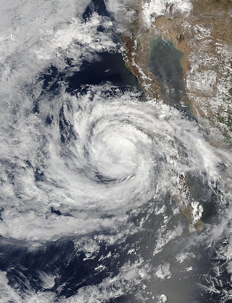
Tropical Storm Emilia skirted the coast of Baja California as it moved northwest into the Pacific Ocean on July 26, 2006. When the Moderate Resolution Imaging Spectroradiometer (MODIS) on NASA’s Aqua satellite captured this image at 1:35 p.m. Pacific Daylight Time (20:25 UTC), the storm had sustained winds of 100 kilometers per hour (65 miles per hour) with stronger gusts. Though these winds were still about ten miles per hour under hurricane status, Emilia has the distinct spiraling clouds and round shape that mark a hurricane. In the hours after this image was taken, Emilia moved out over the Pacific Ocean and degraded into a tropical depression, said the National Hurricane Center. The large image provided above is at MODIS’ maximum resolution of 250 meters per pixel. The image is available in additional resolutions from the MODIS Rapid Response Team. |
|||||
| 日期 | ||||||
| 來源 | http://earthobservatory.nasa.gov/NaturalHazards/natural_hazards_v2.php3?img_id=13733 | |||||
| 作者 | NASA image courtesy Jeff Schmaltz, MODIS Land Rapid Response Team at NASA GSFC | |||||
| 授權許可 (重用此檔案) |
|

檔案歷史
點選日期/時間以檢視該時間的檔案版本。
| 日期/時間 | 縮圖 | 尺寸 | 用戶 | 備註 | |
|---|---|---|---|---|---|
| 目前 | 2020年11月7日 (六) 18:56 | | 5,200 × 6,800(5.71 MB) | FleurDeOdile | 250m |
| 2020年5月9日 (六) 07:30 |  | 5,280 × 5,280(2.81 MB) | Sandy14156 | worldview version | |
| 2006年7月27日 (四) 19:49 |  | 4,800 × 4,800(3.59 MB) | Good kitty | ||
| 2006年7月26日 (三) 20:12 |  | 880 × 880(200 KB) | Good kitty | ||
| 2006年7月26日 (三) 15:03 |  | 300 × 300(31 KB) | Good kitty | ||
| 2006年7月26日 (三) 15:00 |  | 400 × 400(51 KB) | Good kitty | ||
| 2006年7月25日 (二) 20:02 |  | 400 × 400(59 KB) | Good kitty | {{Information| |Description=This image of Tropical Storm Emilia was captured at 1800 UTC on July 25 2006. At the time, winds were approximately 65 miles at the center. |Source=http://rsd.gsfc.nasa.gov/goes/goesproject.html.gif |Date=2006-07-25 |Author=GOE |
檔案用途
下列6個頁面有用到此檔案:
全域檔案使用狀況
以下其他 wiki 使用了這個檔案:
- de.wikipedia.org 的使用狀況
- en.wikipedia.org 的使用狀況
- es.wikipedia.org 的使用狀況
- fr.wikipedia.org 的使用狀況
- nl.wikipedia.org 的使用狀況
- pt.wikipedia.org 的使用狀況
- simple.wikipedia.org 的使用狀況
- www.wikidata.org 的使用狀況