
File:US humid subtropical.png

預覽大小:800 × 552 像素。 其他解析度:320 × 221 像素 | 640 × 441 像素 | 841 × 580 像素。
原始檔案 (841 × 580 像素,檔案大小:15 KB,MIME 類型:image/png)
摘要
| 描述 |
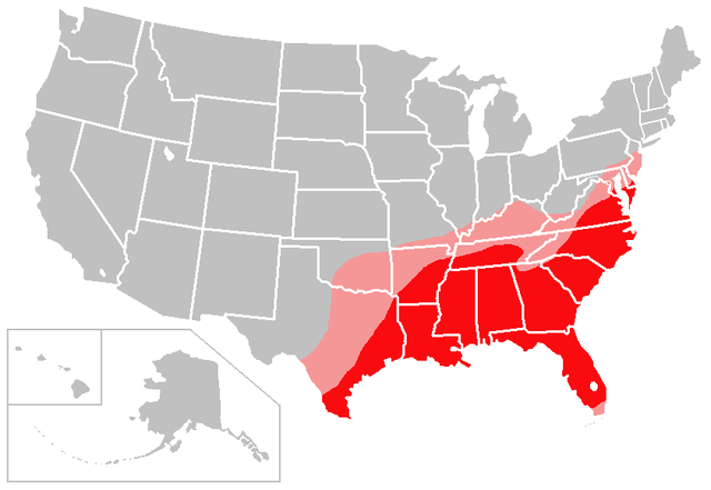
English: The red shading on this map denotes areas of the United States with a solidly humid subtropical climate; the pink shading denotes areas of the United States with a transitional/borderline humid subtropical climate.
I created this map based largely on the information contained in the Humid subtropical climate article, with supplemental information gleaned from articles about various US cities and states. Consider this to be a work in progress and feel free to suggest changes/corrections to me or make them yourself, if necessary. Points of clarification:
|
| 日期 | 2007年一月6日 (原始上傳日期) |
| 來源 | Created by user:Caliga10 |
| 作者 | 英文維基百科的Caliga10 |
授權條款
| 此檔案採用共享創意 姓名標示-相同方式分享 3.0 未在地化版本授權條款。 受免責聲明的約束。 | ||
| 姓名標示: Caliga10 位于英语维基百科 | ||
| ||
| 已新增授權條款標題至此檔案,作為GFDL授權更新的一部份。 |

|
已授權您依據自由軟體基金會發行的無固定段落、封面文字和封底文字GNU自由文件授權條款1.2版或任意後續版本,對本檔進行複製、傳播和/或修改。該協議的副本列在GNU自由文件授權條款中。 受免責聲明的約束。 |
原始上傳日誌
The original description page was here. All following user names refer to en.wikipedia.
- 2007-02-13 04:18 Caliga10 841×580× (15462 bytes) Updated version of this map, based on input from [[user:CrazyC83|CrazyC83]]. The following changes have been made: South Florida (except the Florida Keys) is shaded as a transitional zone (to a full tropical climate; the Keys remain unshaded since they
- 2007-01-06 23:25 Caliga10 841×580× (15505 bytes) Created by [[user:Caliga10]] I created this map based largely on the information contained in the [[Humid subtropical climate]] article, with supplemental information gleaned from articles about various US cities and states. Consider this to be a work in
檔案歷史
點選日期/時間以檢視該時間的檔案版本。
| 日期/時間 | 縮圖 | 尺寸 | 用戶 | 備註 | |
|---|---|---|---|---|---|
| 目前 | 2013年7月27日 (六) 05:56 | | 841 × 580(15 KB) | OgreBot | (BOT): Uploading old version of file from en.wikipedia; originally uploaded on 2007-02-13 04:18:41 by Caliga10 |
| 2013年7月27日 (六) 05:56 |  | 841 × 580(15 KB) | OgreBot | (BOT): Uploading old version of file from en.wikipedia; originally uploaded on 2007-01-06 23:25:26 by Caliga10 | |
| 2013年7月25日 (四) 09:44 |  | 800 × 552(104 KB) | Encore007 | User created page with UploadWizard |
檔案用途
下列頁面有用到此檔案:
全域檔案使用狀況
以下其他 wiki 使用了這個檔案:
- ar.wikipedia.org 的使用狀況
- en.wikipedia.org 的使用狀況
- it.wikipedia.org 的使用狀況
- ja.wikipedia.org 的使用狀況
- no.wikipedia.org 的使用狀況