
File:Upper end of Cow Island, in the Missouri, below the mouth of Cow Creek, Missouri Breaks, Motnana.JPG

預覽大小:800 × 600 像素。 其他解析度:320 × 240 像素 | 640 × 480 像素 | 1,024 × 768 像素。
原始檔案 (1,024 × 768 像素,檔案大小:364 KB,MIME 類型:image/jpeg)
摘要
| 描述 |
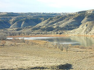
English: This is a view of the upper end of Cow Island, in the Missouri. It lies just below the mouth of Cow Creek. The island is created from sediments washing out from Cow Creek in flood season. This is one of the larger islands in the Missouri. It forms a natural crossing point on the Missouri. During the steamboat era (1860 to the mid 1880's) the Missouri was the path way to the mines in western Montana. Above this point the Missouri had many rapids. In the summer and fall, the river levels dropped, and steamboats could not get up to Ft. Benton, the up river terminus. They had to drop their cargos here. This area became known as Cow Island Landing. The freight was then north and west hauled up Cow Creek, through the Missouri Breaks and out onto the northern Montana plains and on to Ft. Benton. In ancient times Cow Island was a Missouri River crossing point for bison and nomadic Indians. Now the bison and Indians are gone, as are the steamboats. Cow Island lies in a remote and isolated area of the Missouri Breaks in Montana. |
| 日期 | |
| 來源 | 自己的作品 |
| 作者 | Montana Geographic Society |
| 拍攝地點 | | 位於此地的本圖片與其他圖片: OpenStreetMap |
|---|
授權條款
我,本作品的著作權持有者,決定用以下授權條款發佈本作品:
此檔案採用共享創意 姓名標示-相同方式分享 3.0 未在地化版本授權條款。
- 您可以自由:
- 分享 – 複製、發佈和傳播本作品
- 重新修改 – 創作演繹作品
- 惟需遵照下列條件:
- 姓名標示 – 您必須指名出正確的製作者,和提供授權條款的連結,以及表示是否有對內容上做出變更。您可以用任何合理的方式來行動,但不得以任何方式表明授權條款是對您許可或是由您所使用。
- 相同方式分享 – 如果您利用本素材進行再混合、轉換或創作,您必須基於如同原先的相同或兼容的條款,來分布您的貢獻成品。

|
已授權您依據自由軟體基金會發行的無固定段落、封面文字和封底文字GNU自由文件授權條款1.2版或任意後續版本,對本檔進行複製、傳播和/或修改。該協議的副本列在GNU自由文件授權條款中。 |
您可以選擇您需要的授權條款。
檔案歷史
點選日期/時間以檢視該時間的檔案版本。
| 日期/時間 | 縮圖 | 尺寸 | 用戶 | 備註 | |
|---|---|---|---|---|---|
| 目前 | 2024年4月16日 (二) 19:51 | | 1,024 × 768(364 KB) | Beao | Removed watermark |
| 2009年12月13日 (日) 04:40 |  | 1,024 × 768(239 KB) | MontGeogSoc | {{Information |Description={{en|1=This is a view of the upper end of Cow Island, in the Missouri. It lies just below the mouth of Cow Creek. The island is created from sediments washing out from Cow Creek in flood season. This is one of the larger isla |
檔案用途
下列頁面有用到此檔案:
全域檔案使用狀況
以下其他 wiki 使用了這個檔案:
- en.wikipedia.org 的使用狀況