
File:Vendée department location map.svg

此 SVG 檔案的 PNG 預覽的大小:800 × 525 像素。 其他解析度:320 × 210 像素 | 640 × 420 像素 | 1,024 × 672 像素 | 1,280 × 839 像素 | 2,560 × 1,679 像素 | 1,386 × 909 像素。
原始檔案 (SVG 檔案,表面大小:1,386 × 909 像素,檔案大小:336 KB)
摘要
| 描述 |
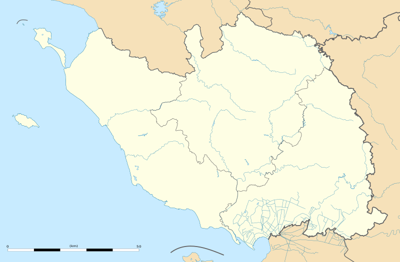
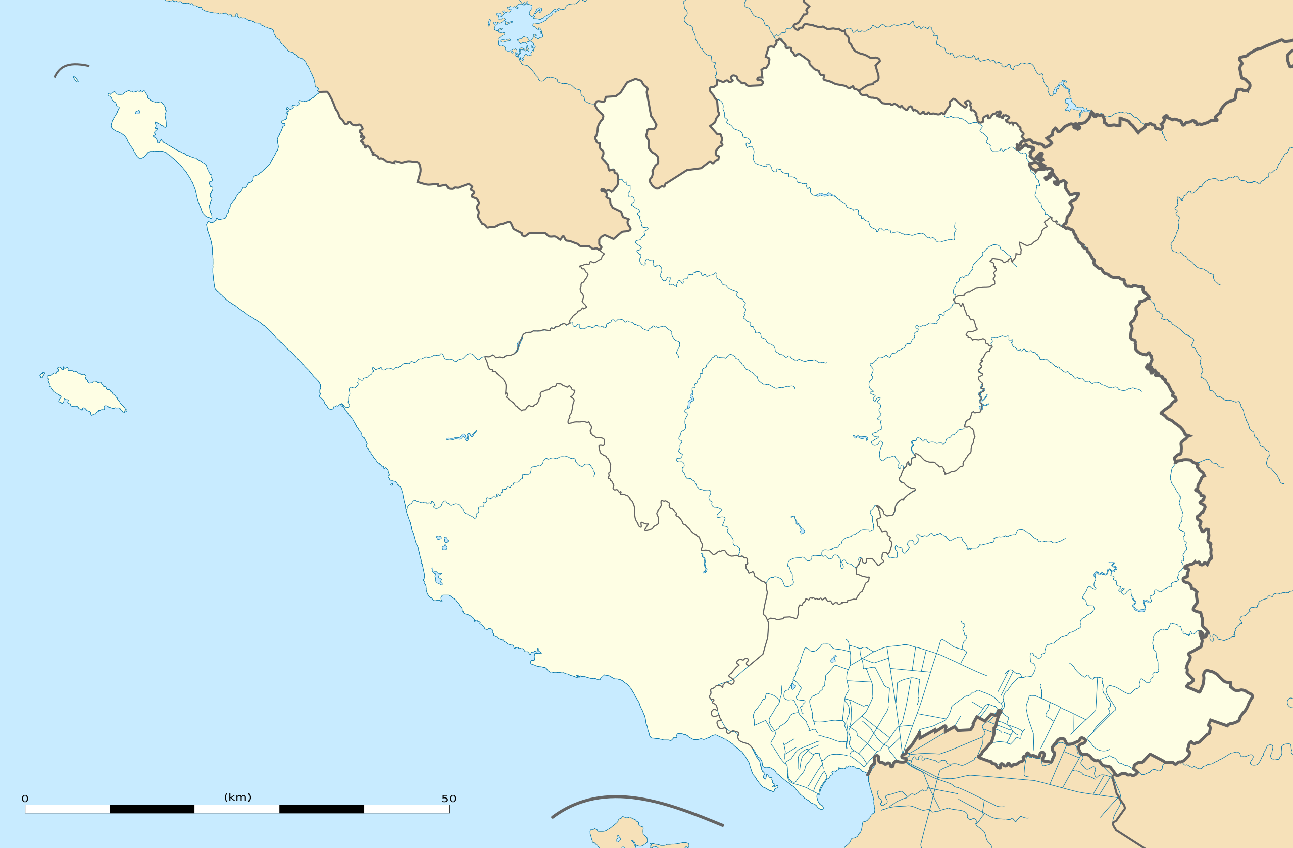
English: Blank administrative map of the department of Vendée, France, as in February 2011, for geo-location purpose, with distinct boundaries for regions, departments and arrondissements.
Français : Carte administrative vierge du département de la Vendée, France, telle qu'en février 2011, destinée à la géolocalisation, avec limite distincte des régions, départements et arrondissements. Estimated scale: 1:440,000 (precision: 110 m)
Geographic limits of the map:
|
||
| 日期 | |||
| 來源 |
自己的作品
|
||
| 作者 | Eric Gaba (Sting - fr:Sting) | ||
| 授權許可 (重用此檔案) |
|
||
| 其他版本 |
|

| 拍攝地點 | | 位於此地的本圖片與其他圖片: OpenStreetMap |
|---|
授權條款
Eric Gaba, Wikimedia Commons user Sting,此作品的版權所有人,決定用以下授權條款發佈本作品:
此檔案採用共享創意 姓名標示-相同方式分享 3.0 未在地化版本授權條款。
姓名標示: Eric Gaba, Wikimedia Commons user Sting
- 您可以自由:
- 分享 – 複製、發佈和傳播本作品
- 重新修改 – 創作演繹作品
- 惟需遵照下列條件:
- 姓名標示 – 您必須指名出正確的製作者,和提供授權條款的連結,以及表示是否有對內容上做出變更。您可以用任何合理的方式來行動,但不得以任何方式表明授權條款是對您許可或是由您所使用。
- 相同方式分享 – 如果您利用本素材進行再混合、轉換或創作,您必須基於如同原先的相同或兼容的條款,來分布您的貢獻成品。
檔案歷史
點選日期/時間以檢視該時間的檔案版本。
| 日期/時間 | 縮圖 | 尺寸 | 用戶 | 備註 | |
|---|---|---|---|---|---|
| 目前 | 2011年3月2日 (三) 21:45 | | 1,386 × 909(336 KB) | Sting | == {{int:filedesc}} == {{Information |Description={{en|Blank administrative map of the department of Vendée, France, as in February 2011, for geo-location purpose, with distinct boundaries for regions, departments and arrondissements.}} { |
檔案用途
超過 100 個頁面有用到此檔案。 下列清單只列出前 100 筆有用到此檔案的頁面。 您也可以檢視完整清單。
- 内米
- 努瓦尔穆捷昂利勒
- 勒塔布利耶
- 勒尚圣佩尔
- 勒布佩尔
- 勒马佐
- 卢瓦
- 圣于尔班 (旺代省)
- 圣佩克西娜
- 圣保罗昂帕雷
- 圣保罗蒙珀尼
- 圣叙尔皮斯-勒韦尔东
- 圣叙尔皮斯昂帕雷
- 圣埃米娜
- 圣塞西尔
- 圣富瓦
- 圣弗洛朗斯
- 圣弗莱沃代卢
- 圣拉代贡德代努瓦耶
- 圣普鲁昂
- 圣樊尚叙雅尔
- 圣樊尚斯泰尔朗日
- 圣热姆拉普莱讷
- 圣皮埃尔迪舍曼
- 圣米歇尔勒克卢克
- 圣米歇尔昂莱尔姆
- 圣米歇尔蒙梅屈尔
- 圣菲尔贝德布艾讷
- 圣西吉斯蒙 (旺代省)
- 圣雷韦朗
- 塞夫尔河畔莫尔塔涅
- 塞里涅
- 尚布勒托
- 尚帕涅莱马赖
- 尚托奈
- 尼约勒勒多朗
- 山地圣母镇
- 布勒伊巴雷
- 布安
- 布尔讷佐
- 布尔诺 (旺代省)
- 布洛涅 (旺代省)
- 布瓦德瑟内
- 布耶-库尔多
- 布费雷
- 拉卡耶尔-圣伊莱尔
- 拉布勒托尼耶尔-拉克莱
- 拉布吕菲耶尔
- 拉布瓦西耶尔德朗德
- 拉布瓦西耶尔德蒙泰居
- 拉梅拉蒂耶尔
- 拉梅耶赖蒂耶
- 拉沙佩勒埃尔米耶
- 拉沙佩勒帕吕欧
- 拉沙佩勒欧利斯
- 拉沙佩勒泰梅尔
- 拉沙佩勒阿沙尔
- 拉莫特阿沙尔
- 拉谢兹勒维孔特
- 拉谢兹日罗
- 拉贝尔纳迪耶尔
- 旧圣皮埃尔
- 格拉翁河畔圣樊尚
- 梅尔旺 (旺代省)
- 梅纳尔拉巴罗蒂耶尔
- 欧蒂兹河畔尼约勒
- 沙奈 (旺代省)
- 沙朗
- 沙耶苏莱索尔莫
- 沙耶莱马赖
- 滨海奥洛讷
- 滨海布雷姆
- 滨海布雷蒂尼奥勒
- 瑟宰
- 穆尚 (旺代省)
- 穆捷莱莫费
- 穆泽伊-圣马丹
- 穆耶龙勒卡普蒂夫
- 穆耶龙昂帕雷
- 纳利耶
- 苏朗
- 莫尔迈松
- 莫雷耶
- 莱布鲁济勒
- 莱河畔穆捷
- 莱河畔马勒伊-迪赛
- 萨莱尔泰讷
- 蒙图尔奈
- 蒙泰居
- 蒙特勒伊 (旺代省)
- 蒙西雷涅
- 谢村
- 贝赛 (旺代省)
- 里耶圣母镇
- 锡古尔奈
- 马列夫尔
- 马尔蒂内
- 马尔赛-圣拉德贡德
- 马耶 (旺代省)
- 马耶宰
檢視連結到這個檔案的更多連結。
全域檔案使用狀況
以下其他 wiki 使用了這個檔案:
- als.wikipedia.org 的使用狀況
- de.wikipedia.org 的使用狀況
- eo.wikipedia.org 的使用狀況
- Les Sables-d'Olonne
- Ŝablono:Situo sur mapo Francio Vendée
- L'Aiguillon-sur-Mer
- Fontenay-le-Comte
- Sainte-Radégonde-des-Noyers
- Puyravault (Vendée)
- Saint-Michel-en-l'Herm
- Champagné-les-Marais
- Triaize
- Longeville-sur-Mer
- Noirmoutier-en-l'Île
- La Roche-sur-Yon (stacidomo)
- Chantonnay
- Île-d'Yeu
- Montaigu (stacidomo)
- Montaigu (Vendée)
- Montaigu-Vendée
- Les Sables-d'Olonne (stacidomo)
- Saint-Hilaire-de-Riez (stacidomo)
- Saint-Hilaire-de-Riez
- Saint-Gilles-Croix-de-Vie (stacidomo)
- Saint-Gilles-Croix-de-Vie
- Challans (stacidomo)
- La Chaize-le-Vicomte (stacidomo)
- La Chaize-le-Vicomte
- L'Herbergement - Les Brouzils (stacidomo)
- L'Herbergement
- Les Brouzils
- Luçon (stacidomo)
- Chantonnay (stacidomo)
- Olonne-sur-Mer (stacidomo)
- Olonne-sur-Mer
- Belleville-Vendée (stacidomo)
- Bellevigny
- Belleville-sur-Vie
- Bournezeau (stacidomo)
- Bournezeau
- Cugand (stacidomo)
- Cugand
- Fougeré (stacidomo)
- Fougeré (Vendée)
- Pouzauges (stacidomo)
- Pouzauges
- La Meilleraie-Tillay
檢視此檔案的更多全域使用狀況。