
File:VenusLanderTopo.jpg
預覽大小:800 × 576 像素。 其他解析度:320 × 230 像素 | 640 × 460 像素 | 1,024 × 737 像素 | 1,280 × 921 像素 | 2,560 × 1,842 像素 | 3,650 × 2,626 像素。
原始檔案 (3,650 × 2,626 像素,檔案大小:4.95 MB,MIME 類型:image/jpeg)
摘要
| 描述 | |
| 日期 | |
| 來源 |
Source: A combination of the following Public Domain data sources |
| 作者 | Zamonin |


授權條款
我,本作品的著作權持有者,決定用以下授權條款發佈本作品:
此檔案採用共享創意 姓名標示-相同方式分享 3.0 未在地化版本授權條款。
- 您可以自由:
- 分享 – 複製、發佈和傳播本作品
- 重新修改 – 創作演繹作品
- 惟需遵照下列條件:
- 姓名標示 – 您必須指名出正確的製作者,和提供授權條款的連結,以及表示是否有對內容上做出變更。您可以用任何合理的方式來行動,但不得以任何方式表明授權條款是對您許可或是由您所使用。
- 相同方式分享 – 如果您利用本素材進行再混合、轉換或創作,您必須基於如同原先的相同或兼容的條款,來分布您的貢獻成品。
檔案歷史
點選日期/時間以檢視該時間的檔案版本。
| 日期/時間 | 縮圖 | 尺寸 | 用戶 | 備註 | |
|---|---|---|---|---|---|
| 目前 | 2023年9月22日 (五) 12:14 | | 3,650 × 2,626(4.95 MB) | Zamonin | new color scheme |
| 2023年9月22日 (五) 12:13 |  | 3,650 × 2,626(5.05 MB) | Zamonin | new color scheme | |
| 2023年9月7日 (四) 20:35 |  | 3,650 × 2,626(5.08 MB) | Zamonin | new layout | |
| 2020年12月15日 (二) 08:04 |  | 1,900 × 1,250(1.72 MB) | Zamonin | Added Venera 7 | |
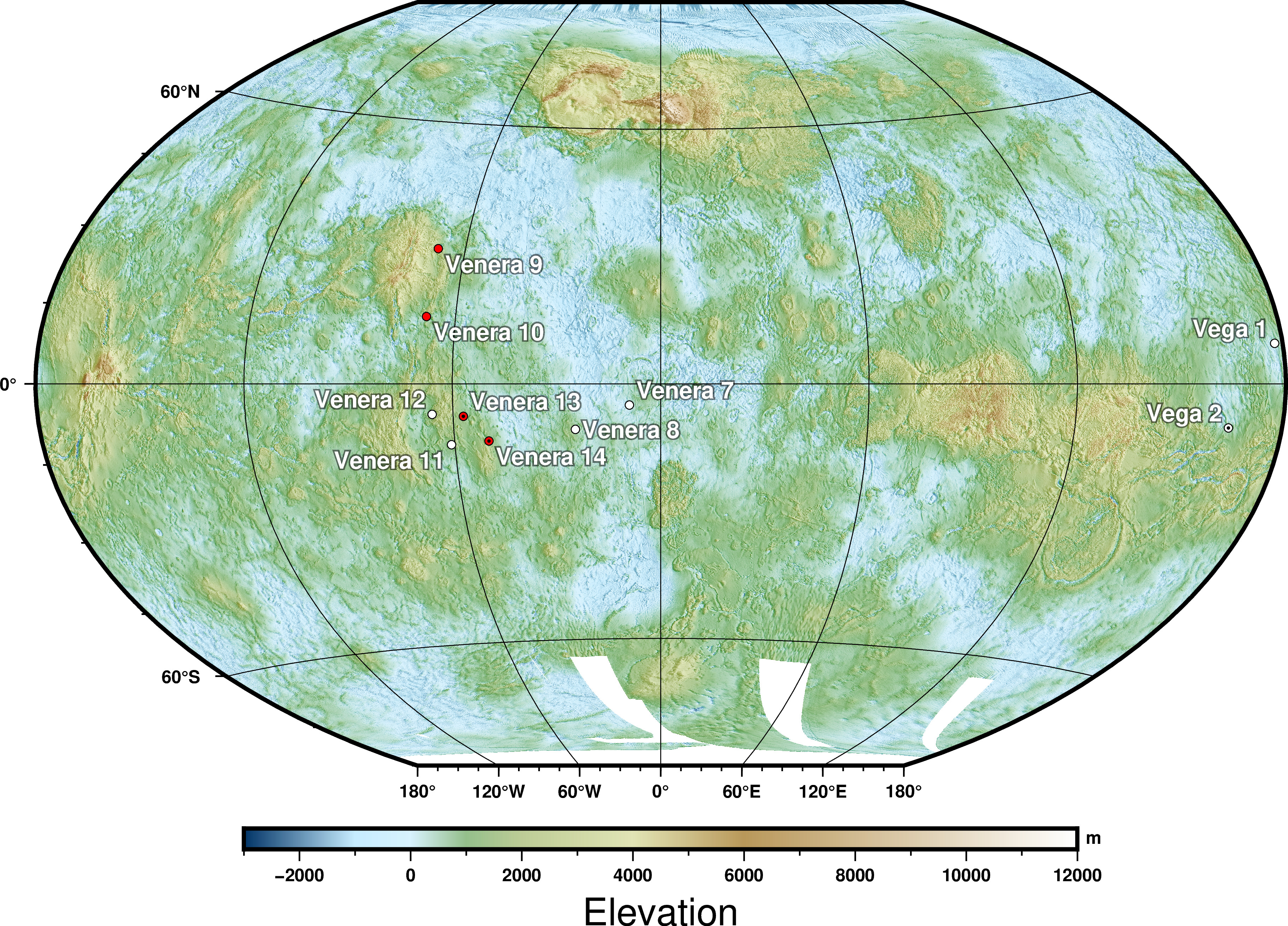
| 2016年8月4日 (四) 20:40 |  | 2,000 × 1,300(2.11 MB) | Zamonin | Added positions of all landers. Red points indicate images taken, black central dots surface samples | |
| 2013年7月31日 (三) 08:59 |  | 1,500 × 1,060(643 KB) | Zamonin | increased resolution of grid | |
| 2013年7月24日 (三) 10:55 |  | 1,500 × 1,060(584 KB) | Zamonin | User created page with UploadWizard |
檔案用途
全域檔案使用狀況
以下其他 wiki 使用了這個檔案:
- af.wikipedia.org 的使用狀況
- ar.wikipedia.org 的使用狀況
- bn.wikipedia.org 的使用狀況
- en.wikipedia.org 的使用狀況
- en.wikibooks.org 的使用狀況
- es.wikipedia.org 的使用狀況
- fa.wikipedia.org 的使用狀況
- fi.wikipedia.org 的使用狀況
- fr.wikipedia.org 的使用狀況
- gv.wikipedia.org 的使用狀況
- hu.wikipedia.org 的使用狀況
- hy.wikipedia.org 的使用狀況
- id.wikipedia.org 的使用狀況
- ko.wikipedia.org 的使用狀況
- mk.wikipedia.org 的使用狀況
- mt.wikipedia.org 的使用狀況
- pt.wikipedia.org 的使用狀況
- sr.wikipedia.org 的使用狀況
- tr.wikipedia.org 的使用狀況
- uk.wikipedia.org 的使用狀況
- vi.wikipedia.org 的使用狀況
- www.wikidata.org 的使用狀況