布勒內灣
外觀
(重新導向自布勒内湾)


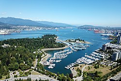
布勒內灣(英語:Burrard Inlet)是位於加拿大卑詩省西南部的峽灣(內灣),於對上一次冰河時期時形成,並是溫哥華港的所在。西起佐治亞海峽,東至滿地寶,從西至東長約25公里,沿岸大部份地區皆已都市化。內灣沿岸的城鎮包括溫哥華市、本拿比、滿地寶、西溫區、北溫區和北溫市;後三者坐落內灣的北岸,合稱為北岸城鎮。大致呈南北走向的印第安灣則於滿地寶以西約12公里處與布勒內灣匯合,並向北伸延約20公里。
現時共有三條天橋橫跨布勒內灣,由西至東分別為獅門橋、鋼鐵工人紀念第二海峽橋以及第二海峽鐵路橋。此外,海上巴士亦在灣內提供來往溫哥華市中心和北溫市的載客渡輪服務。
歷史
[編輯]現布勒內灣一帶原為海岸沙利殊原住民的聚居地。西班牙探險家胡安·卡拉斯科和荷西·瑪利亞·納爾維斯於1791年駛船進入內灣的西部。[1]英國船長喬治·溫哥華則於1792年航行至此處,並將之命名為「布勒內灣」以紀念英國海軍上將哈利·布勒-尼爾。[2]
英國海軍部於1888年發行的報告中如此形容布勒內灣:
與北美西岸的其它大海灣不同,布勒內灣可容許任何大小的蒸汽船方便進出,灣內大部分水域的深度亦足以讓船隻停泊。它也接近菲沙河,兩者之間可開拓道路來連接,而海灣也成為太平洋與加拿大鐵路的終點站;種種因素令此內灣更具重要性。內灣可細分成三個不同的海港:英吉利灣,即外港;在第一海峽鄰的溫哥華(前稱高豪港);以及位於內灣東端的滿地寶。[註 1][3]
參考資料及備註
[編輯]- ^ Kendrick, John. The Voyage of Sutil and Mexicana, 1792: The last Spanish exploration of the Northwest Coast of America. Spokane, Washington: The Arthur H. Clark Company. 1990: 19. ISBN 0-87062-203-X.
- ^ Bartroli, Thomas. Genesis of Vancouver City. Vancouver: (Self-published). 1997
- ^ Hydrographic Office of the British Admiralty (1888). The British Columbia Pilot. London, UK: Hydrographic Department of the Admiralty. Page 136.
備註
[編輯]- ^ 原文為:「Burrard inlet differs from most of the great sounds of this coast in being comparatively easy of access to steam vessels of any size or class, and in the convenient depth of water for anchorage which may be found in almost every part of it; its close proximity to Fraser river, with the great facilities for constructing roads between the two places, and its having become the terminus of the Pacific and Canadian Railway, likewise add considerably to its importance. It is divided into three distinct harbours, viz., English bay or the outer anchorage; Vancouver (formerly called Coal harbour), above the First Narrows; and Port Moody at the head of the eastern arm of the inlet.」
外部連結
[編輯]- Fisheries and Oceans Canada | Pacific Region | Indian Arm-Burrard Inlet (頁面存檔備份,存於互聯網檔案館) 加拿大聯邦漁業及海洋部 印第安灣-布勒內灣頁面
