
File:2006 North Korean nuclear test.svg

此 SVG 檔案的 PNG 預覽的大小:473 × 408 像素。 其他解析度:278 × 240 像素 | 557 × 480 像素 | 890 × 768 像素 | 1,187 × 1,024 像素 | 2,374 × 2,048 像素。
原始檔案 (SVG 檔案,表面大小:473 × 408 像素,檔案大小:71 KB)
摘要
| 描述 |
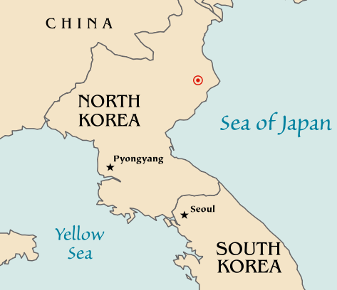
Map of the North Korean nuclear test of October 9, 2006. The red marker indicates the estimated location of the test (41.311°N, 129.114°E). Based off of maps from the CIA World Factbook. |
| 日期 | 2006年10月10日 (原始上傳日期) |
| 來源 | 无法识别来源。根据版权声明推断为其自己的作品。 |
| 作者 | 无法识别作者。根据版权声明推断作者为Mobius。 |
| 其他版本 |
|


授權條款
| 我,此作品的版權所有人,釋出此作品至公共領域。此授權條款在全世界均適用。 這可能在某些國家不合法,如果是的話: 我授予任何人有權利使用此作品於任何用途,除受法律約束外,不受任何限制。 |
檔案歷史
點選日期/時間以檢視該時間的檔案版本。
| 日期/時間 | 縮圖 | 尺寸 | 用戶 | 備註 | |
|---|---|---|---|---|---|
| 目前 | 2006年10月10日 (二) 20:48 | | 473 × 408(71 KB) | Mobius | + Crop area, proper license |
| 2006年10月10日 (二) 20:43 |  | 981 × 801(71 KB) | Mobius | Map of the North Korean nuclear test of October 9, 2006. The red marker indicates the estimated location of the test (41.311°N, 129.114°E). Based off of maps from the CIA World Factbook. |
檔案用途
沒有使用此檔案的頁面。
全域檔案使用狀況
以下其他 wiki 使用了這個檔案:
- ca.wikipedia.org 的使用狀況
- en.wikipedia.org 的使用狀況
- ia.wikipedia.org 的使用狀況
- ko.wikipedia.org 的使用狀況
- nl.wikipedia.org 的使用狀況
- no.wikipedia.org 的使用狀況
- pl.wikinews.org 的使用狀況
- ta.wikinews.org 的使用狀況
- www.wikidata.org 的使用狀況