
File:Aerial view of Porirua City Centre and Porirua Station.jpg

預覽大小:800 × 534 像素。 其他解析度:320 × 214 像素 | 640 × 427 像素 | 1,024 × 683 像素 | 1,280 × 854 像素 | 2,560 × 1,709 像素 | 5,145 × 3,434 像素。
原始檔案 (5,145 × 3,434 像素,檔案大小:7.05 MB,MIME 類型:image/jpeg)
摘要
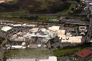
| 描述 | Viewed from west, with considerable visible detail at 100%. In upper right with the crowded parking lot is Porirua Station. North City Shopping Centre is on right (tan colored building with Kmart and Farmer's logo). State Highway 1 (SH 1N) and railway are at top. Green-walled building on left is a Countdown supermarket. |
| 日期 | |
| 來源 | Aerial view of Porirua City Centre and Porirua Station |
| 作者 | Derrick Coetzee (User:Dcoetzee) |
| 拍攝地點 | | 位於此地的本圖片與其他圖片: OpenStreetMap |
|---|
授權條款
| 此檔案在創用CC CC0 1.0 通用公有領域貢獻宣告之下分發。 | |
| 在此宣告之下分發本作品者,已依據各國著作權法,在全世界放棄其對本作品所擁有的著作權及所有相關相似的法律權利,從而將本作品貢獻至公有領域。您可以複製、修改、分發和演示該作品,用於任何商業用途,所有這些都不需要請求授權。
|
| This image, originally posted to Flickr, was reviewed on 14 September 2013 by the administrator or reviewer Dcoetzee, who confirmed that it was available on Flickr under the stated license on that date. |
檔案歷史
點選日期/時間以檢視該時間的檔案版本。
| 日期/時間 | 縮圖 | 尺寸 | 用戶 | 備註 | |
|---|---|---|---|---|---|
| 目前 | 2013年9月14日 (六) 05:33 | | 5,145 × 3,434(7.05 MB) | Dcoetzee | Transferred from Flickr by User:Dcoetzee using flickr2commons |
檔案用途
全域檔案使用狀況
以下其他 wiki 使用了這個檔案:
- ar.wikipedia.org 的使用狀況
- arz.wikipedia.org 的使用狀況
- avk.wikipedia.org 的使用狀況
- ca.wikipedia.org 的使用狀況
- de.wikivoyage.org 的使用狀況
- en.wikipedia.org 的使用狀況
- en.wikivoyage.org 的使用狀況
- es.wikipedia.org 的使用狀況
- hi.wikipedia.org 的使用狀況
- it.wikipedia.org 的使用狀況
- ja.wikipedia.org 的使用狀況
- ka.wikipedia.org 的使用狀況
- ko.wikipedia.org 的使用狀況
- no.wikipedia.org 的使用狀況
- pl.wikipedia.org 的使用狀況
- ru.wikipedia.org 的使用狀況
- simple.wikipedia.org 的使用狀況
- tr.wikipedia.org 的使用狀況
- uk.wikipedia.org 的使用狀況
- vo.wikipedia.org 的使用狀況
- www.wikidata.org 的使用狀況
- zh-yue.wikipedia.org 的使用狀況