跳至內容

File:Ancient Khorasan highlighted.jpg

頁面內容不支援其他語言。
這個檔案來自維基共享資源
維基百科,自由的百科全書

Ancient_Khorasan_highlighted.jpg (373 × 320 像素,檔案大小:58 KB,MIME 類型:image/jpeg


描述

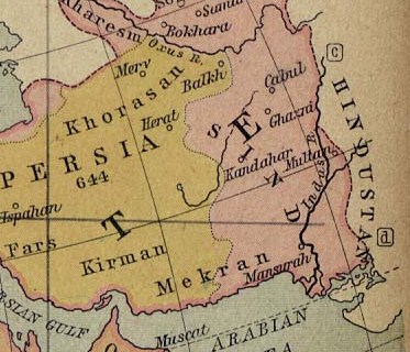
Map showing Ancient Persia in light yellowish and the the land called Sind (most of today's Afghanistan and part of Pakistan) in pinkish.

A number of ancient references are made to the names shown in this map. Ibn Batutta writes in 1333 AD: [1]

We travelled from there to Naysabur, one of the four capitals of Khurasan.... We travelled thence to Parwan, where I met the amir Buruntayh. He treated me well and wrote to his representatives at Ghazna enjoining them to show me honour. We went on to the village of Charkh [Charikar], it being now summer, and from there to the town of Ghazna. This is the town of the famous warrior-sultan Mahmud ibn Sabuktagin, one of the greatest of rulers, who made frequent raids into India and captured cities and fortresses there. His grave is in this city and is surmounted by a hospice. The greater part of the town is in ruins and nothing but a fraction of it remains, though it was once a large city. It has an exceedingly cold climate, and the inhabitants move from it in the cold season to Qandahar, a large and prosperous town three nights journey from Ghazna, but I did not visit it. We travelled on to Kabul, formerly a vast town, the site of which is now occupied by a village inhabited by a tribe of Persians called Afghans. They hold mountains and defiles and possess considerable strength, and are mostly highwaymen. Their principle mountain is called Kuh Sulayman... From Kabul we rode to Karmash, which is a fortress belonging to the Afghans... On reaching Sind I followed this practice and bought horses, camels, white slaves and other goods from the merchants. I had already bought from an Iraqi merchant in Ghazna about thirty horses and a camel with a load of arrows, for this is one of the things presented to the sultan. This merchant went off to Khurasan and on returning to India received his money from me. After crossing the river of Sind called Panj Ab, our way led through a forrest of reeds, in which I saw a rhinoceros for the first time. After two days' march we reached Janani, a large and fine town on the bank of the river Sind. Its people are a people called the Samira, whose ancestors established themselves there on the conquest of Sind in the time of al-Hajjaj [712 A.D.]

日期
來源 University of Texas at Austin, Middle East and Europe - The Caliphate in 750 (293K)
作者 William R. Shepherd
授權許可
(重用此檔案)
Public domain

本作品在其來源國以及其他版權期限是作者逝世後70年或以下的國家與地區屬於公有領域


你必須增加美國公有領域標籤顯示為何這個作品在美國屬於公有領域。
此作品無已知的著作權限制,亦不受所有相關和鄰接的權利限制。
其他版本 full version: File:Califate 750.jpg

說明

添加單行說明來描述出檔案所代表的內容

在此檔案描寫的項目

描繪內容

創作作者 Chinese (Hong Kong) (已轉換拼寫)

威廉·謝潑德 中文 (已轉換拼寫)

多媒體型式 繁體中文 (已轉換拼寫)

image/jpeg

校驗和 繁體中文 (已轉換拼寫)

18a4d90f811c5cd49f824d42f0a27bbb22790c6a

斷定方法:​SHA-1 中文 (已轉換拼寫)

資料大小 Chinese (Hong Kong) (已轉換拼寫)

59,539 位元組

320 像素

373 像素

檔案歷史

點選日期/時間以檢視該時間的檔案版本。

日期/時間縮⁠圖尺寸用戶備⁠註
目前2010年10月22日 (五) 19:07於 2010年10月22日 (五) 19:07 版本的縮圖373 × 320(58 KB)Officer{{Information |Description= |Source= |Date= |Author= |Permission= |other_versions= }}

下列頁面有用到此檔案:

全域檔案使用狀況

以下其他 wiki 使用了這個檔案:

檢視此檔案的更多全域使用狀況

詮釋資料