
File:Auroras over North America.jpg

預覽大小:600 × 600 像素。 其他解析度:240 × 240 像素 | 480 × 480 像素 | 768 × 768 像素 | 1,024 × 1,024 像素 | 2,048 × 2,048 像素 | 3,677 × 3,677 像素。
原始檔案 (3,677 × 3,677 像素,檔案大小:2.05 MB,MIME 類型:image/jpeg)
摘要
| 描述 |
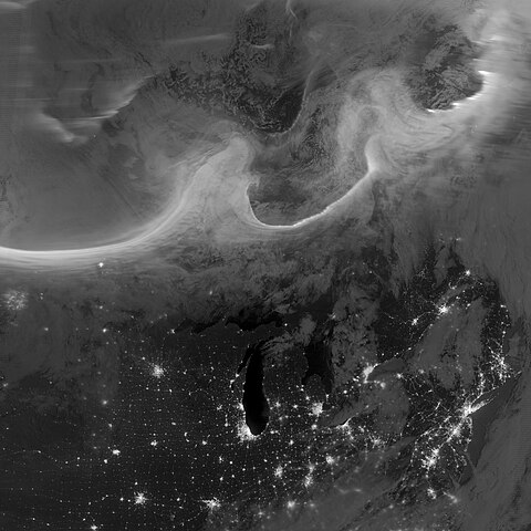
Deutsch: Bild der Aurora borealis vom frühen Morgen des 8. Oktobers 2012, aufgenommen mit dem "Tag-Nacht-Band" (DNB, 505 bis 890 Nanometer – hauptsächlich sichtbares Licht von grün bis nahem ultraviolett) der Visible Infrared Imaging Radiometer Suite (VIIRS) an Bord des Satelliten Suomi National Polar-orbiting Partnership (Suomi NPP). Die Lichter im Bild ziehen sich über die kanadischen Provinzen Quebec und Ontario und sind Teil des Gesamtovals, das sich durch einen geomagnetischen Sturm bis in mittlere Breiten hinab ausdehnte. English: Using the “day-night band” (DNB, 505 to 890 nanometres – primarily visible light from green to near visible infrared) of the Visible Infrared Imaging Radiometer Suite (VIIRS), the Suomi National Polar-orbiting Partnership (Suomi NPP) satellite acquired this view of the aurora borealis early on the morning of October 8, 2012. The northern lights stretch across Canada’s Quebec and Ontario provinces in the image, and are part of the auroral oval that expanded to middle latitudes because of a geomagnetic storm. |
| 日期 | |
| 來源 | NASA Earth Observatory |
| 作者 | Jesse Allen and Robert Simmon |
| 拍攝地點 | | 位於此地的本圖片與其他圖片: OpenStreetMap |
|---|
| 註解 | 該圖片含有註解:在維基媒體共享資源上查看註解 |
授權條款
| 本作品由NASA創作,屬於公有領域。根據NASA的版權政策:“NASA的創作除非另有聲明否則不受版權保護。”(參見:Template:PD-USGov/zh,NASA版權政策或JPL圖像使用政策) | ||
 |
警告:
|
檔案歷史
點選日期/時間以檢視該時間的檔案版本。
| 日期/時間 | 縮圖 | 尺寸 | 用戶 | 備註 | |
|---|---|---|---|---|---|
| 目前 | 2012年10月12日 (五) 10:00 | | 3,677 × 3,677(2.05 MB) | Originalwana | {{Information |Description ={{en|1=Using the “day-night band” (DNB) of the Visible Infrared Imaging Radiometer Suite (VIIRS), the Suomi National Polar-orbiting Partnership (Suomi NPP) satellite acquired this view of the aurora borealis early on ... |
檔案用途
下列頁面有用到此檔案:
全域檔案使用狀況
以下其他 wiki 使用了這個檔案:
- et.wikipedia.org 的使用狀況
- fr.wikipedia.org 的使用狀況
- id.wikipedia.org 的使用狀況
- sk.wikipedia.org 的使用狀況