
File:Axial tilt vs tropical and polar circles.svg

此 SVG 檔案的 PNG 預覽的大小:512 × 186 像素。 其他解析度:320 × 116 像素 | 640 × 233 像素 | 1,024 × 372 像素 | 1,280 × 465 像素 | 2,560 × 930 像素。
原始檔案 (SVG 檔案,表面大小:512 × 186 像素,檔案大小:115 KB)
摘要
| 描述 |
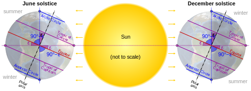
English: Relationship between Earth's axial tilt (ε) to the tropical and polar circles. The SVG file uses CSS animation with feDisplacementMap. The orthographic projection was rendered from the NASA Blue Marble Next Generation. |
|
| 日期 | (NASA bitmap: 1 July 2004) | |
| 來源 |
個人作品,使用: http://visibleearth.nasa.gov/view.php?id=73580
|
|
| 作者 | cmglee, NASA | |
| 其他版本 |
|
|
| SVG開發 |

授權條款
| 本作品由NASA創作,屬於公有領域。根據NASA的版權政策:“NASA的創作除非另有聲明否則不受版權保護。”(參見:Template:PD-USGov/zh,NASA版權政策或JPL圖像使用政策) | ||
 |
警告:
|
檔案歷史
點選日期/時間以檢視該時間的檔案版本。
| 日期/時間 | 縮圖 | 尺寸 | 用戶 | 備註 | |
|---|---|---|---|---|---|
| 目前 | 2023年11月17日 (五) 00:43 | 512 × 186(115 KB) | Cmglee | Add CSS animation | |
| 2022年7月27日 (三) 00:22 | 512 × 186(47 KB) | Cmglee | Unify colours and label seasons | ||
| 2019年8月10日 (六) 08:39 | 512 × 186(47 KB) | Incnis Mrsi | <?xml version="1.0" encoding="UTF-8"?> – see en:Wikipedia:Village pump (technical) #SVG preview rendering Greek letter incorrectly // Editing SVG source code using c:User:Rillke/SVGedit.js | ||
| 2015年7月2日 (四) 14:25 | 512 × 186(47 KB) | Cmglee | Add labels. | ||
| 2015年7月1日 (三) 16:06 | 512 × 205(46 KB) | Cmglee | User created page with UploadWizard |
檔案用途
下列頁面有用到此檔案:
全域檔案使用狀況
以下其他 wiki 使用了這個檔案:
- af.wikipedia.org 的使用狀況
- ar.wikipedia.org 的使用狀況
- as.wikipedia.org 的使用狀況
- ba.wikipedia.org 的使用狀況
- bcl.wikipedia.org 的使用狀況
- bg.wikipedia.org 的使用狀況
- bn.wikipedia.org 的使用狀況
- bs.wikipedia.org 的使用狀況
- ca.wikipedia.org 的使用狀況
- de.wikivoyage.org 的使用狀況
- en.wikipedia.org 的使用狀況
- en.wikibooks.org 的使用狀況
- es.wikipedia.org 的使用狀況
- ga.wikipedia.org 的使用狀況
- ha.wikipedia.org 的使用狀況
- hi.wikipedia.org 的使用狀況
- hr.wikipedia.org 的使用狀況
- id.wikipedia.org 的使用狀況
- is.wikipedia.org 的使用狀況
- it.wikibooks.org 的使用狀況
- kn.wikipedia.org 的使用狀況
- ml.wikipedia.org 的使用狀況
- ms.wikipedia.org 的使用狀況
檢視此檔案的更多全域使用狀況。