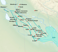
File:Basse Mesopotamie PB.PNG
外觀
Basse_Mesopotamie_PB.PNG (440 × 393 像素,檔案大小:157 KB,MIME 類型:image/png)
檔案歷史
點選日期/時間以檢視該時間的檔案版本。
| 日期/時間 | 縮圖 | 尺寸 | 用戶 | 備註 | |
|---|---|---|---|---|---|
| 目前 | 2023年2月26日 (日) 10:21 |  | 440 × 393(157 KB) | Zunkir | opacité, cours d'eau, villes |
| 2017年12月10日 (日) 21:02 |  | 1,026 × 736(588 KB) | Bulldoc | aggiunta Umma ed il terreno della Guedemma, causa della guerra con Lagash | |
| 2017年1月13日 (五) 01:17 |  | 1,026 × 736(814 KB) | Kindattu2004 | Cities of Kisurra and Kutalla added | |
| 2010年9月28日 (二) 16:59 |  | 1,026 × 736(826 KB) | Zunkir | {{Information |Description={{en|1=Location map of the main cities of Lower Mesopotamia during the paleo-babylonian period (2004-1595 BC). With the approximate course of the rivers and the ancient shoreline of the Gulf.}} {{fr|1=Carte de localisation des p |
檔案用途
沒有使用此檔案的頁面。
全域檔案使用狀況
以下其他 wiki 使用了這個檔案:
- ar.wikipedia.org 的使用狀況
- arz.wikipedia.org 的使用狀況
- ca.wikipedia.org 的使用狀況
- ceb.wikipedia.org 的使用狀況
- en.wikipedia.org 的使用狀況
- es.wikipedia.org 的使用狀況
- fi.wikibooks.org 的使用狀況
- fr.wikipedia.org 的使用狀況
- it.wikipedia.org 的使用狀況
- pl.wikipedia.org 的使用狀況
檢視此檔案的更多全域使用狀況。


