
File:California Freeway and Expressway System.svg

此 SVG 檔案的 PNG 預覽的大小:514 × 600 像素。 其他解析度:206 × 240 像素 | 411 × 480 像素 | 658 × 768 像素 | 878 × 1,024 像素 | 1,755 × 2,048 像素 | 576 × 672 像素。
原始檔案 (SVG 檔案,表面大小:576 × 672 像素,檔案大小:1.44 MB)
摘要
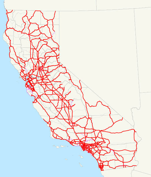
| 描述 | This is a map of the California Freeway and Expressway System; routes that have been removed from it are in thin purple, and other routes are very thin gray. Email me if you would like a copy of the GIS data I created for the highways. |
| 日期 | 2007年十二月7日 (原始上傳日期) |
| 來源 | 无法识别来源。根据版权声明推断为其自己的作品。 |
| 作者 | 无法识别作者。根据版权声明推断作者为NE2。 |
授權條款
| 我,此作品的版權所有人,釋出此作品至公共領域。此授權條款在全世界均適用。 這可能在某些國家不合法,如果是的話: 我授予任何人有權利使用此作品於任何用途,除受法律約束外,不受任何限制。 |
檔案歷史
點選日期/時間以檢視該時間的檔案版本。
| 日期/時間 | 縮圖 | 尺寸 | 用戶 | 備註 | |
|---|---|---|---|---|---|
| 目前 | 2008年1月6日 (日) 12:33 | | 576 × 672(1.44 MB) | NE2 | Added all other routes to the background. |
| 2007年12月20日 (四) 03:52 |  | 576 × 672(1.4 MB) | NE2 | Fixed SR 111 and SR 86 with respect to SR 86S. | |
| 2007年12月20日 (四) 03:43 |  | 576 × 672(1.4 MB) | NE2 | Modified some positions. | |
| 2007年12月7日 (五) 00:07 |  | 576 × 672(1.32 MB) | NE2 | Thinned the lines. | |
| 2007年12月7日 (五) 00:05 |  | 576 × 672(1.32 MB) | NE2 | == Summary == This is a map of the California Freeway and Expressway System; routes that have been removed from it are in thin purple. Email me if you would like a copy of the GIS data I created for the highways. [[Category:Stat |
檔案用途
下列頁面有用到此檔案:
全域檔案使用狀況
以下其他 wiki 使用了這個檔案:
- en.wikipedia.org 的使用狀況
- es.wikipedia.org 的使用狀況
- www.wikidata.org 的使用狀況