
File:Centroamerica prehispanica siglo XVI.svg

此 SVG 檔案的 PNG 預覽的大小:800 × 528 像素。 其他解析度:320 × 211 像素 | 640 × 423 像素 | 1,024 × 676 像素 | 1,280 × 845 像素 | 2,560 × 1,691 像素 | 250,980 × 165,770 像素。
原始檔案 (SVG 檔案,表面大小:250,980 × 165,770 像素,檔案大小:499 KB)
| 警告 | 部分瀏覽器在瀏覽此圖片的完整大小時可能會遇到困難:該圖片中有數量巨大的像素點,可能無法完全載入或者導致您的瀏覽器停止回應。 |
|---|
摘要
| 描述 |
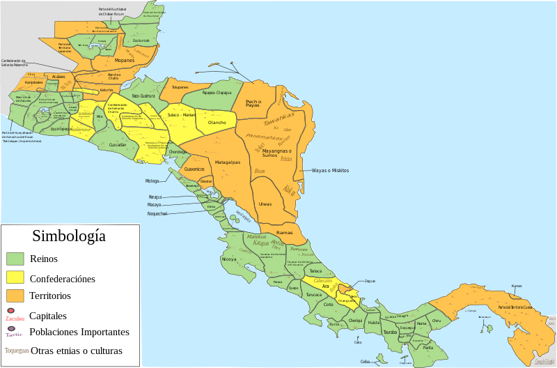
Español: Mapa de las diferentes entidades territoriales que existían en Centroamérica en el siglo XVI antes de la llegada de los españoles. En lo referente a la simbología, se tomaron en cuenta las siguientes consideraciones: Reinos, todas aquellas entidades territoriales (llamadas comúnmente señoríos o cacicazgos) que contaban con una capital y un señor principal; confederación, todas aquellas entidades conformadas por señoríos o poblaciones que aunque eran independientes tenían algún tipo de integración o alianza; territorio, todas aquellas regiones conformadas por varios señoríos o poblaciones (ya sean sedentarias, nómadas o seminómadas) que no contaban con algún tipo de integración o alianza, y de las que hay nula o escasa información de como estaban constituidos o de como se encontraban delimitados los territorios de todos o algunas entidades que se encontraban en esa región; como poblaciones importantes se toman en cuenta aquellas poblaciones que eran parte de la organización administrativa de alguna entidad, aquellas poblaciones que tuvieron un papel destacado en la conquista española de alguna entidad (como aquellas en las que se libraron batallas importantes), y las poblaciones donde se hablaban o donde aún se hablan algunas lenguas o dialectos; por último, es de mencionar que las otras etnias o culturas mostradas podrían haber estado sometidas a la entidad donde se mencionan o podrían ser independientes de dicha entidad
English: Map of the different territorial entities that existed in Central America in the XVI century before the arrive of the spanish people. With regard to symbology, the following considerations were taken: "reino" (Kingdoms), all those territorial entities (commonly called "señoríos" (lordships) or "cacicazgos") that had a capital and a principal lord; "confederación" (confederation), all those entities conformed by "señoríos" or towns that although they were independent had some type of integration or alliance; "territorio" (territory), all those regions conformed by several "señoríos" or towns (whether sedentary, nomadic or semi-nomadic) that did not count on some type of integration or alliance, and of which there is null or little information of how they were constituted or as were delimited the territories of all or someone entities that were in that region; on the other hand, as important towns are mentioned those towns that were part of the administrative organization of some entity, those towns that had a prominent role in the Spanish conquest of some entity (such as those in which important battles were fought), and the localities where some languages or dialects were spoken, or where they are still spoken today; Finally, it is worth mentioning that the other ethnic groups or cultures shown could have been submitted to the entity where they are mentioned or could be independent of said entity. |
| 日期 | |
| 來源 |
自己的作品, for the elaboration of this picture were used the next resources: This file of wikimedia commons was used for great part of Costa Rica:  And, pictures or information of the nexts documents, publications or books:
|
| 作者 | Juan Miguel |
授權條款
我,本作品的著作權持有者,決定用以下授權條款發佈本作品:
此檔案採用共享創意 姓名標示-相同方式分享 3.0 未在地化版本授權條款。
- 您可以自由:
- 分享 – 複製、發佈和傳播本作品
- 重新修改 – 創作演繹作品
- 惟需遵照下列條件:
- 姓名標示 – 您必須指名出正確的製作者,和提供授權條款的連結,以及表示是否有對內容上做出變更。您可以用任何合理的方式來行動,但不得以任何方式表明授權條款是對您許可或是由您所使用。
- 相同方式分享 – 如果您利用本素材進行再混合、轉換或創作,您必須基於如同原先的相同或兼容的條款,來分布您的貢獻成品。
檔案歷史
點選日期/時間以檢視該時間的檔案版本。
| 日期/時間 | 縮圖 | 尺寸 | 用戶 | 備註 | |
|---|---|---|---|---|---|
| 目前 | 2022年12月5日 (一) 06:23 | | 250,980 × 165,770(499 KB) | Juan Miguel | Arreglando algunos detalles |
| 2019年5月5日 (日) 08:34 |  | 250,976 × 165,771(664 KB) | Juan Miguel | Arreglando tamaño de fuente de algunos textos | |
| 2019年5月5日 (日) 08:30 |  | 250,976 × 165,771(663 KB) | Juan Miguel | Arreglando tamaño de fuente de algunos textos | |
| 2019年5月5日 (日) 08:25 |  | 250,976 × 165,771(663 KB) | Juan Miguel | Arreglando algunos textos | |
| 2019年5月5日 (日) 06:18 |  | 250,976 × 165,771(661 KB) | Juan Miguel | Agregó capitales y otras poblaciones importantes, con lo cuál también se mejora los límites entre varias entidades. Además se añaden otras etnias y culturas que pueden formar parte de dicha entidad o ser independientes, y finalmente se amplía la imagen para que los diversos elementos se han más visibles | |
| 2018年12月18日 (二) 05:16 |  | 15,744 × 11,093(276 KB) | Juan Miguel | Correcciones menores | |
| 2018年12月17日 (一) 10:52 |  | 15,744 × 11,093(277 KB) | Juan Miguel | Pequeñas correciones | |
| 2018年10月22日 (一) 03:02 |  | 15,744 × 11,093(278 KB) | Juan Miguel | Arreglo menor en el cuadro de simbología | |
| 2018年10月22日 (一) 02:44 |  | 15,744 × 11,093(278 KB) | Juan Miguel | Arreglo algunas fronteras, pongo colores claros, reduzco la cantidad de colores y año el cuadro de simbología. | |
| 2017年7月16日 (日) 10:13 |  | 15,744 × 11,093(274 KB) | Juan Miguel | Arreglo algunas fronteras y agrego el nombre de los lagos y el color a los océanos. |
檔案用途
下列頁面有用到此檔案:
全域檔案使用狀況
以下其他 wiki 使用了這個檔案:
- ar.wikipedia.org 的使用狀況
- ast.wikipedia.org 的使用狀況
- bn.wikipedia.org 的使用狀況
- ca.wikipedia.org 的使用狀況
- en.wikipedia.org 的使用狀況
- es.wikipedia.org 的使用狀況
- Historia de Panamá
- Historia de Honduras
- Historia de El Salvador
- Pipil
- Historia de Guatemala
- Historia de Nicaragua
- Historia de América Central
- Historia de Belice
- Señorío de Cuzcatlán
- Idioma náhuat
- Reino quiché de Q'umarkaj
- Usuario discusión:Montgomery/Archivo 15
- Chajoma
- Honduras prehispánica
- Historia precolombina de Honduras
- Historia territorial de Panamá
- Uluas
- Gran Darién
- eu.wikipedia.org 的使用狀況
- fr.wikipedia.org 的使用狀況
- gl.wikipedia.org 的使用狀況
- io.wikipedia.org 的使用狀況
- ja.wikipedia.org 的使用狀況
- simple.wikipedia.org 的使用狀況