
File:Cheneso 2023-01-25 1100Z.jpg

預覽大小:462 × 599 像素。 其他解析度:185 × 240 像素 | 370 × 480 像素 | 592 × 768 像素 | 789 × 1,024 像素 | 1,579 × 2,048 像素 | 3,700 × 4,800 像素。
原始檔案 (3,700 × 4,800 像素,檔案大小:10.15 MB,MIME 類型:image/jpeg)
摘要
| 描述 |
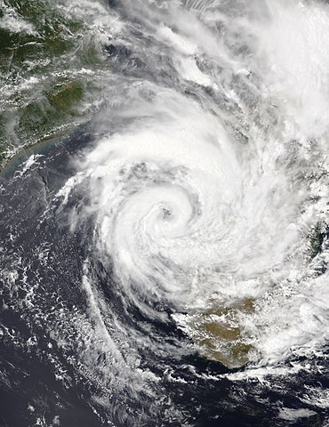
English: This true-color image of Tropical Cyclone Cheneso was captured on the afternoon of 25 January 2023, at 11:00 UTC or (2:00 PM Madagascar Local time), by the Visible Infrared Imaging Radiometer Suite (VIIRS) instrument flying aboard NASA/NOAA's NOAA-20 satellite. Cheneso was a moderately strong cyclone and heavy rain producer that originated from a tropical disturbance east of Madagascar during the 2022-23 South-West Indian Ocean cyclone season in mid-January 2023. When this image was captured, Cheneso was nearly stationary over the Mozambique channel just off the west coast of Madagascar, where it delivered flooding rains in the country. Cheneso killed at least 25 people, and its damages are unknown as of now. When this was captured, Cheneso was intensifying as a Category 1 equivalent cyclone, with winds of 80 mph (130 km/h) (70 knots) on the 1-min Saffir-Simpson scale and winds of 75 mph (121 km/h) (65 knots) on the 10-min MFR cyclone scale making it a "tropical cyclone" on that scale. It had a minimum central pressure of 973 mbar (28.7 inHg), and it would ultimately reach its peak intensity around 12 hours later during the evening to night hours. |
| 日期 | |
| 來源 | EOSDIS Worldview |
| 作者 | NASA/NOAA-20 |
授權條款
| 本作品由NASA創作,屬於公有領域。根據NASA的版權政策:“NASA的創作除非另有聲明否則不受版權保護。”(參見:Template:PD-USGov/zh,NASA版權政策或JPL圖像使用政策) | ||
 |
警告:
|
檔案歷史
點選日期/時間以檢視該時間的檔案版本。
| 日期/時間 | 縮圖 | 尺寸 | 用戶 | 備註 | |
|---|---|---|---|---|---|
| 目前 | 2023年1月25日 (三) 15:54 | | 3,700 × 4,800(10.15 MB) | TheWxResearcher | Uploaded a work by NASA/NOAA-20 from [https://worldview.earthdata.nasa.gov/ EOSDIS Worldview] with UploadWizard |
檔案用途
下列頁面有用到此檔案:
全域檔案使用狀況
以下其他 wiki 使用了這個檔案:
- de.wikipedia.org 的使用狀況
- en.wikipedia.org 的使用狀況
- fr.wikipedia.org 的使用狀況
- id.wikipedia.org 的使用狀況
- pt.wikipedia.org 的使用狀況
- uk.wikipedia.org 的使用狀況
- www.wikidata.org 的使用狀況