
File:Deception Island Map.svg

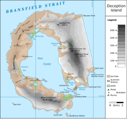
此 SVG 檔案的 PNG 預覽的大小:644 × 599 像素。 其他解析度:258 × 240 像素 | 516 × 480 像素 | 825 × 768 像素 | 1,101 × 1,024 像素 | 2,201 × 2,048 像素 | 820 × 763 像素。
原始檔案 (SVG 檔案,表面大小:820 × 763 像素,檔案大小:461 KB)
| 描述 |
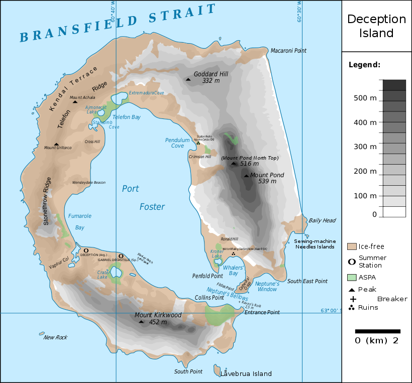
Français : carte de l'île de la Déception avec les toponymes + la position des stations ainsi que des zones protégées
English: map of Deception Island with the topography and the location of the stations and protected zones |
| 日期 | (UTC) |
| 來源 | |
| 作者 |
|
| 這是一張修飾過的圖片,即本圖片是用軟體修改過後的版本。原版圖片來源:Ile de la Deception.svg。修改者:Fitzgabbro。
|
我,本作品的著作權持有者,決定用以下授權條款發佈本作品:
此檔案採用創用CC 姓名標示 3.0 未在地化版本授權條款。
- 您可以自由:
- 分享 – 複製、發佈和傳播本作品
- 重新修改 – 創作演繹作品
- 惟需遵照下列條件:
- 姓名標示 – 您必須指名出正確的製作者,和提供授權條款的連結,以及表示是否有對內容上做出變更。您可以用任何合理的方式來行動,但不得以任何方式表明授權條款是對您許可或是由您所使用。

|
已授權您依據自由軟體基金會發行的無固定段落、封面文字和封底文字GNU自由文件授權條款1.2版或任意後續版本,對本檔進行複製、傳播和/或修改。該協議的副本列在GNU自由文件授權條款中。 |
您可以選擇您需要的授權條款。
原始上傳日誌
This image is a derivative work of the following images:
- File:Ile_de_la_Deception.svg licensed with Cc-by-3.0, GFDL
- 2010-06-19T09:08:35Z Treehill 820x763 (464885 Bytes) carrés noirs (tentative)
- 2010-06-18T17:48:51Z Treehill 820x763 (465569 Bytes) deux dernières légendes alignées
- 2010-06-18T17:30:49Z Treehill 820x763 (465601 Bytes) nom de la baie à gauche
- 2010-06-18T17:20:48Z Treehill 820x763 (465594 Bytes) déplacement de certains textes + 1ère tentative de suppression des carrés
- 2010-06-18T14:02:39Z Treehill 820x763 (465599 Bytes) {{Information |Description={{fr|1=carte de l'île de la Déception avec les toponymes + la position des stations ainsi que des zones protégées}} |Source={{own}} |Author=[[User:Treehill|Treehill]] |Date= |Permission= |other_
Uploaded with derivativeFX
檔案歷史
點選日期/時間以檢視該時間的檔案版本。
| 日期/時間 | 縮圖 | 尺寸 | 用戶 | 備註 | |
|---|---|---|---|---|---|
| 目前 | 2018年5月13日 (日) 21:59 | | 820 × 763(461 KB) | Hogweard | Rm duplicate |
| 2018年3月25日 (日) 12:45 |  | 820 × 763(462 KB) | Hogweard | Corrected height of Pond North Top; Fumarole Bay and additional names. | |
| 2016年9月18日 (日) 16:35 |  | 820 × 763(459 KB) | Maproom | 1.) Word "Station" no longer extends off edge of image 2.) "Peak" is spelled without a ffinal "t" 3.) "Breaker" is written in the right place instead of overwritten on "peak" | |
| 2010年10月10日 (日) 11:01 |  | 820 × 763(459 KB) | Fitzgabbro | Fixed curved writing | |
| 2010年10月9日 (六) 22:11 |  | 820 × 763(353 KB) | Fitzgabbro | {{Information |Description={{fr|1=carte de l'île de la Déception avec les toponymes + la position des stations ainsi que des zones protégées}} {{en|1=map of Deception Island with the topography and the location of the stations and protected zones}} |S |
檔案用途
全域檔案使用狀況
以下其他 wiki 使用了這個檔案:
- ceb.wikipedia.org 的使用狀況
- cs.wikipedia.org 的使用狀況
- de.wikipedia.org 的使用狀況
- Deception Island
- Mount Achala
- Telefon Ridge
- Telefon Bay
- Port Foster
- Ajmonecatsee
- Stancomb Cove
- Laguna Hill
- Fildes Point
- Neptunes Bellows
- Whalers Bay
- Penfold Point
- Collins Point
- Crater Lake (Deception Island)
- Mount Kirkwood
- Entrance Point
- Crimson Hill
- Kendall Terrace
- Kroner Lake
- Låvebrua Island
- South Point (Deception Island)
- New Rock (Südliche Shetlandinseln)
- Mount Pond
- Primero de Mayo Bay
- Ravn Rock
- Ronald Hill
- South East Point
- Stonethrow Ridge
- Vapour Col
- en.wikipedia.org 的使用狀況
- eu.wikipedia.org 的使用狀況
- it.wikipedia.org 的使用狀況
- ja.wikipedia.org 的使用狀況
- lld.wikipedia.org 的使用狀況
- nds.wikipedia.org 的使用狀況
- nl.wikipedia.org 的使用狀況
- nn.wikipedia.org 的使用狀況
- pl.wikipedia.org 的使用狀況
檢視此檔案的更多全域使用狀況。