
File:El Ferdan Railway Bridge.jpg

預覽大小:800 × 429 像素。 其他解析度:320 × 172 像素 | 640 × 343 像素 | 1,024 × 549 像素 | 1,280 × 687 像素 | 2,222 × 1,192 像素。
原始檔案 (2,222 × 1,192 像素,檔案大小:283 KB,MIME 類型:image/jpeg)
摘要
| 描述 |
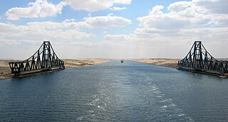
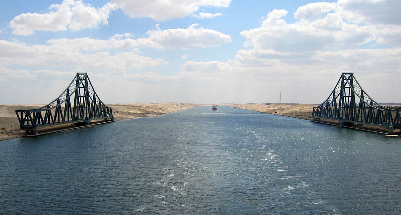
English: El Ferdan Railway Bridge, the longest swing bridge in the world, runs from the west of Suez Canal to the east into Sinai, opens most of the time to allow sailing ships to pass in the canal, and closes during passage of trains.
Deutsch: Die El-Ferdan-Brücke ist die längste Drehbrücke der Welt. Sie verbindet das Westufer des Suezkanals mit dem Sinai |
| 日期 | |
| 來源 | 自己的作品 |
| 作者 | H Nawara |
| 目標地點 | | 位於此地的本圖片與其他圖片: OpenStreetMap |
|---|
授權條款
| 我,此作品的版權所有人,釋出此作品至公共領域。此授權條款在全世界均適用。 這可能在某些國家不合法,如果是的話: 我授予任何人有權利使用此作品於任何用途,除受法律約束外,不受任何限制。 |
檔案歷史
點選日期/時間以檢視該時間的檔案版本。
| 日期/時間 | 縮圖 | 尺寸 | 用戶 | 備註 | |
|---|---|---|---|---|---|
| 目前 | 2017年9月2日 (六) 15:43 | | 2,222 × 1,192(283 KB) | Zeugma fr | Rot 2.1° (horizon line); crop to 16/9 (remove overhead sky and water); auto contrast |
| 2010年7月3日 (六) 18:16 |  | 2,272 × 1,704(362 KB) | H Nawara~commonswiki | {{Information |Description={{en|1=El Ferdan Railway Bridge, the longest swing bridge in the world, runs from the east of suez canal to the west into Sinai, opens most of the time to allow sailing ships to pass in the canal, and closes during passage of tr |
檔案用途
下列頁面有用到此檔案:
全域檔案使用狀況
以下其他 wiki 使用了這個檔案:
- als.wikipedia.org 的使用狀況
- ar.wikipedia.org 的使用狀況
- arz.wikipedia.org 的使用狀況
- ba.wikipedia.org 的使用狀況
- bg.wikipedia.org 的使用狀況
- da.wikipedia.org 的使用狀況
- de.wikipedia.org 的使用狀況
- de.wikivoyage.org 的使用狀況
- en.wikipedia.org 的使用狀況
- es.wikipedia.org 的使用狀況
- eu.wikipedia.org 的使用狀況
- fr.wikipedia.org 的使用狀況
- he.wikipedia.org 的使用狀況
- ja.wikipedia.org 的使用狀況
- lb.wikipedia.org 的使用狀況
- nl.wikipedia.org 的使用狀況
- no.wikipedia.org 的使用狀況
- ru.wikipedia.org 的使用狀況
- sl.wikipedia.org 的使用狀況
- sv.wikipedia.org 的使用狀況
- uk.wikipedia.org 的使用狀況
- vec.wikipedia.org 的使用狀況
- www.wikidata.org 的使用狀況