
File:Hurricane Kenna 24 oct 2002 1750Z.jpg

預覽大小:461 × 599 像素。 其他解析度:184 × 240 像素 | 369 × 480 像素 | 591 × 768 像素 | 788 × 1,024 像素 | 1,575 × 2,048 像素 | 8,000 × 10,400 像素。
原始檔案 (8,000 × 10,400 像素,檔案大小:12.43 MB,MIME 類型:image/jpeg)
| 警告 | 部分瀏覽器在瀏覽此圖片的完整大小時可能會遇到困難:該圖片中有數量巨大的像素點,可能無法完全載入或者導致您的瀏覽器停止回應。 |
|---|
摘要
| 描述 |
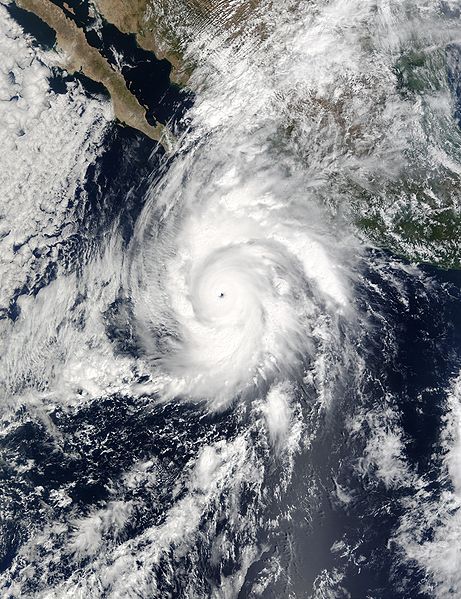
Packing winds of 160 miles per hour (257 km per hour), Hurricane Kenna intensified into a Category 5 storm on Oct. 25, 2002. Kenna is shown in this true-color image bearing down on Mexico’s west coast. This scene was acquired by the Moderate Resolution Imaging Spectroradiometer (MODIS), flying aboard NASA’s Terra satellite, on October 24. Category 5 hurricanes, the strongest category, are capable of causing catastrophic damage. The storm is predicted to make landfall by late morning on Oct. 25. |
|||||
| 日期 | ||||||
| 來源 | http://rapidfire.sci.gsfc.nasa.gov/gallery/?2002297-1024/Kenna.A2002297.1750.2km.jpg | |||||
| 作者 | Image courtesy of MODIS Rapid Response Project at NASA/GSFC | |||||
| 授權許可 (重用此檔案) |
|
|||||
| 其他版本 | Image:HurricaneKenna2002.jpg |

檔案歷史
點選日期/時間以檢視該時間的檔案版本。
| 日期/時間 | 縮圖 | 尺寸 | 用戶 | 備註 | |
|---|---|---|---|---|---|
| 目前 | 2006年11月12日 (日) 16:59 | | 8,000 × 10,400(12.43 MB) | Good kitty | ==Summary== {{Information |Description=Packing winds of 160 miles per hour (257 km per hour), Hurricane Kenna intensified into a Category 5 storm on Oct. 25, 2002. Kenna is shown in this true-color image bearing down on Mexico’s west coast. This scene |
檔案用途
下列19個頁面有用到此檔案:
- 除名太平洋飓风名称列表
- 飓风肯纳
- Talk:飓风肯纳
- Wikipedia:优良条目/1959年墨西哥飓风
- Wikipedia:优良条目/2014年2月
- Wikipedia:优良条目/2014年2月15日
- Wikipedia:优良条目/2014年2月19日
- Wikipedia:优良条目/飓风肯纳
- Wikipedia:典范条目/2002年飓风肯纳
- Wikipedia:典范条目/2014年2月
- Wikipedia:典范条目/2014年2月12日
- Wikipedia:典范条目/2015年7月
- Wikipedia:典范条目/2015年7月19日
- Wikipedia:典范条目/2017年9月
- Wikipedia:典范条目/2017年9月22日
- Wikipedia:典范条目/2020年5月
- Wikipedia:典范条目/2020年5月25日
- Portal:美國/特色條目
- Portal:美國/特色條目/76
全域檔案使用狀況
以下其他 wiki 使用了這個檔案:
- de.wikipedia.org 的使用狀況
- en.wikipedia.org 的使用狀況
- Hurricane Kenna
- User:Icelandic Hurricane/Contributions
- List of Pacific hurricanes
- Wikipedia:Today's featured article/July 2007
- Portal:Tropical cyclones/Anniversaries/October
- Portal:Tropical cyclones/Anniversaries/October/25
- Wikipedia:Today's featured article/July 28, 2007
- Portal:Tropical cyclones/Featured article/Hurricane Kenna
- Wikipedia:Wikipedia Signpost/2009-01-03/Dispatches
- Wikipedia talk:Wikipedia Signpost/2009-01-03/Dispatches
- Tropical cyclones in 2002
- es.wikipedia.org 的使用狀況
- fr.wikipedia.org 的使用狀況
- hu.wikipedia.org 的使用狀況
- pt.wikipedia.org 的使用狀況
- tl.wikipedia.org 的使用狀況
- uk.wikipedia.org 的使用狀況
- www.wikidata.org 的使用狀況