跳至內容

File:ISS018-E-038182 lrg.jpg

頁面內容不支援其他語言。
這個檔案來自維基共享資源
維基百科,自由的百科全書

原始檔案 (1,440 × 960 像素,檔案大小:689 KB,MIME 類型:image/jpeg


摘要

描述
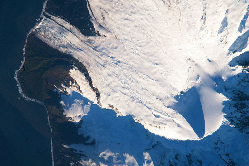
English: Heard Island is located in the southern Indian Ocean, approximately 1,550 kilometers (963 miles) north of Antarctica. The island is a visible part of the Kerguelen Plateau, a submerged feature on the seafloor. The plateau was formed when large amounts of volcanic rock erupted over a geologically short time period. (When large amounts of volcanic rock erupt beneath the ocean from processes other than seafloor spreading, geologists refer to them as large igneous provinces.) Most of Heard Island is formed from volcanic rocks associated with the Big Ben stratovolcano. The northeastern slopes of the volcano are visible in shadow at the lower right of this detailed astronaut photograph.

Recent volcanic activity at Heard Island has occurred at 2,745-meter (9,006-foot) Mawson Peak, which sits within a breached caldera on the southwestern side of the Big Ben Volcano. Calderas form when a magma chamber beneath a volcano empties and collapses. The shadow cast by Mawson Peak points directly to the crescent-shaped caldera rim. Detailed geologic study of Big Ben Volcano is complicated by the presence of several glaciers, including Gotley and Lied Glaciers on the southwestern slopes. This image, taken during Southern Hemisphere summer, also reveals non-glaciated volcanic rock (light to dark brown) on either side of Gotley Glacier.


International Space Station InsigniaISS Crew Earth Observations: ISS018-E-038182International Space Station emblem
Identification
Mission ISS018 (Expedition 18)
Roll E
Frame 038182
Country or Geographic Name ANTARCTICA
Features S.W. AREA OF HEARD I., MAWSON PEAK, FREMANTLE PEAK
Center Point Latitude -53.1° N
Center Point Longitude 73.5° E
Camera
Camera Tilt 36°
Camera Focal Length 800 mm
Camera Nikon D2Xs
Film 4288 x 2848 pixel CMOS sensor, RGBG imager color filter.
Quality
Percentage of Cloud Cover 0-10%
Nadir What is Nadir?
Date 2009-02-28
Time 12:54:41
Nadir Point Latitude -51.3° N
Nadir Point Longitude 71.9° E
Nadir to Photo Center Direction Southeast
Sun Azimuth 271°
Spacecraft Altitude 197 nautical miles (365 km)
Sun Elevation Angle 11°
Orbit Number 2885
日期
來源 http://earthobservatory.nasa.gov/IOTD/view.php?id=37488&src=iotdrss
作者 Astronaut photograph ISS018-E-38182 was acquired on February 28, 2009, with a Nikon D2Xs digital camera fitted with an 800 mm lens, and is provided by the ISS Crew Earth Observations experiment and the Image Science & Analysis Laboratory, Johnson Space Center. The image was taken by the Expedition 18 crew. The image in this article has been cropped and enhanced to improve contrast. Lens artifacts have been removed. The International Space Station Program supports the laboratory to help astronauts take pictures of Earth that will be of the greatest value to scientists and the public, and to make those images freely available on the Internet. Additional images taken by astronauts and cosmonauts can be viewed at the NASA/JSC Gateway to Astronaut Photography of Earth. Caption William L. Stefanov, NASA-JSC.

授權條款

Public domain 本作品由NASA創作,屬於公有領域。根據NASA的版權政策:“NASA的創作除非另有聲明否則不受版權保護。”(參見:Template:PD-USGov/zhNASA版權政策JPL圖像使用政策
警告:

說明

添加單行說明來描述出檔案所代表的內容

在此檔案描寫的項目

描繪內容

赫德島 中文 (已轉換拼寫)

著作權狀態 繁體中文 (已轉換拼寫)

斷定方法:​美國聯邦政府的作品 繁體中文 (已轉換拼寫)

多媒體型式 繁體中文 (已轉換拼寫)

image/jpeg

檔案歷史

點選日期/時間以檢視該時間的檔案版本。

日期/時間縮⁠圖尺寸用戶備⁠註
目前2009年3月16日 (一) 03:57於 2009年3月16日 (一) 03:57 版本的縮圖1,440 × 960(689 KB)Shizhao{{Information |Description={{en|1=Heard Island is located in the southern Indian Ocean, approximately 1,550 kilometers (963 miles) north of Antarctica. The island is a visible part of the Kerguelen Plateau, a submerged feature on the seafloor. The plateau

全域檔案使用狀況

以下其他 wiki 使用了這個檔案:

檢視此檔案的更多全域使用狀況

詮釋資料