
File:Ioke 2006-08-24 2155Z.jpg

預覽大小:600 × 600 像素。 其他解析度:240 × 240 像素 | 480 × 480 像素 | 768 × 768 像素 | 1,024 × 1,024 像素 | 2,048 × 2,048 像素 | 4,400 × 4,400 像素。
原始檔案 (4,400 × 4,400 像素,檔案大小:3.25 MB,MIME 類型:image/jpeg)
摘要
| 描述 |
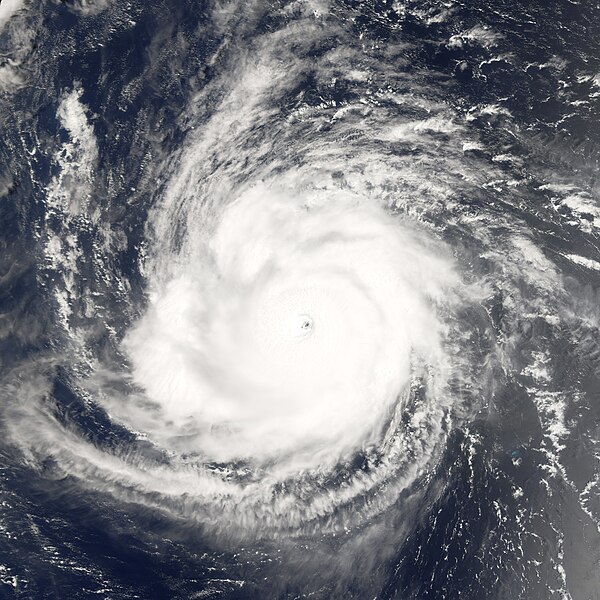
Hurricane Ioke started as all tropical cyclones do, as a depression—an area of low atmospheric pressure. After forming August 19, 2006, the depression quickly developed into a tropical storm, the threshold for earning a name. Ioke is the Hawaiian word for the name “Joyce.” Storms and hurricanes in the central Pacific are unusual, but they occur often enough for there to be a naming convention, applied by the Central Pacific Hurricane Center in Honolulu. The last named central Pacific storm was Huko in 2002. Ioke rose all the way to hurricane strength in less than 24 hours. Hurricane Ioke at the time of this image had a well-defined round shape, clear spiral-arm structure, and a distinct but cloud-filled (or “closed”) eye. The University of Hawaii’s Tropical Storm Information Center reported that Hurricane Ioke had sustained winds of around 255 kilometers per hour (160 miles per hour) at the time this satellite image was acquired. |
|||||
| 日期 | August 24, 2006, at 11:55 a.m. local time (21:55 UTC) | |||||
| 來源 | http://earthobservatory.nasa.gov/NaturalHazards/natural_hazards_v2.php3?img_id=13811 | |||||
| 作者 | NASA image created by Jesse Allen, Earth Observatory, using data provided by the MODIS Rapid Response team. | |||||
| 授權許可 (重用此檔案) |
|

檔案歷史
點選日期/時間以檢視該時間的檔案版本。
| 日期/時間 | 縮圖 | 尺寸 | 用戶 | 備註 | |
|---|---|---|---|---|---|
| 目前 | 2006年11月19日 (日) 19:31 | | 4,400 × 4,400(3.25 MB) | Good kitty | the colors are really messed up on this one |
| 2006年8月25日 (五) 23:05 |  | 4,400 × 4,400(3.33 MB) | Tom | {{Information |Description=Hurricane Ioke started as all tropical cyclones do, as a depression—an area of low atmospheric pressure. After forming August 19, 2006, the depression quickly developed into a tropical storm, the threshold for earning a name. |
檔案用途
下列16個頁面有用到此檔案:
- 2006年太平洋飓风季时间轴
- 颶風伊歐凱
- Talk:颶風伊歐凱
- User:Bluedecklibrary/2006年太平洋飓风季时间轴
- User:Chairrex
- Wikipedia:优良条目/2016年4月
- Wikipedia:优良条目/2016年4月7日
- Wikipedia:优良条目/飓风伊欧凯
- Wikipedia:典范条目/2016年4月
- Wikipedia:典范条目/2016年4月10日
- Wikipedia:典范条目/2018年7月
- Wikipedia:典范条目/2018年7月6日
- Wikipedia:典范条目/2022年2月
- Wikipedia:典范条目/2022年2月25日
- Wikipedia:典范条目/颶風伊歐凱
- WikiProject:太平洋颱風季/條目/典範條目
全域檔案使用狀況
以下其他 wiki 使用了這個檔案:
- ca.wikipedia.org 的使用狀況
- de.wikipedia.org 的使用狀況
- en.wikipedia.org 的使用狀況
- User talk:AySz88
- User talk:Fableheroesguild
- Talk:List of storms in the 2006 Pacific hurricane season
- User talk:WmE
- User talk:Juan andrés
- Timeline of the 2006 Pacific hurricane season
- User talk:WeatherVane
- User talk:Coredesat/Newsletters
- User:Bob rulz/Hurricane Herald
- User talk:A7x/Newsletters
- User:Chacor/Sandbox/IHCtest
- User talk:Pobbie Rarr/Tropical cyclones WikiProject Newsletter archive
- User talk:Ajm81/Newsletters
- Wikipedia:WikiProject Tropical cyclones/Newsletter/Archive 5
- User talk:Nightstallion/η
- User talk:Patrickrox11
- User talk:Hurricanehink/Archive 7
- User:WindRunner/WPTC newsletters
- User talk:Sean Whitton/Archive 8
- User talk:Icelandic Hurricane/October Archive
- User talk:The Grid/Archive 1
- User talk:Miss Madeline/Archive Late 2006
- User talk:Erebus555/archive3
- User talk:Robomaeyhem/Archive 3
- User talk:Cyclone1/Archive2
- User talk:Jamie C/Archive 2
- User talk:Titoxd/Archive19
- User talk:Typhoonchaser/Archive 1
- User talk:Sarsaparilla39/Archive 1
- Wikipedia:WikiProject Tropical cyclones/Newsletter/Archive
- User:Yellow Evan/ 2006 Pacific hurricane season
- Wikipedia:Today's featured article/July 2009
- Wikipedia:Today's featured article/July 22, 2009
- User:Fishhead/Archive1
- User:Tfmbty/List of the most intense tropical cyclones since 1979
- es.wikipedia.org 的使用狀況
- ja.wikipedia.org 的使用狀況
- ko.wikipedia.org 的使用狀況
- nl.wikipedia.org 的使用狀況
- no.wikipedia.org 的使用狀況
- pt.wikipedia.org 的使用狀況
- ru.wikipedia.org 的使用狀況
- simple.wikipedia.org 的使用狀況
- th.wikipedia.org 的使用狀況
- tl.wikipedia.org 的使用狀況