
File:Jeanne 2004-09-25 1615Z.jpg

原始檔案 (5,200 × 6,800 像素,檔案大小:7.08 MB,MIME 類型:image/jpeg)
摘要
| 描述 |
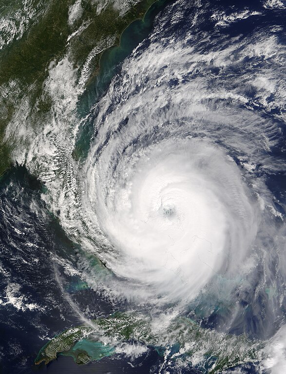
The eye of Hurricane Jeanne was centered over the narrow gap of water between Abaco Island, right, and Grand Bahama Island, left, on September 25, 2004, when the Moderate Resolution Imaging Spectroradiometer (MODIS) on NASA’s Terra satellite acquired this image. As the eye of the storm passed directly over Abaco Island and skirted the north coast of Grand Bahama Island, it strengthened from a Category 2 storm to a dangerous Category 3 hurricane. Between 8 a.m. and 11 a.m. EDT, sustained wind speeds went from 165 kilometers per hour (105 mph) to 185 kph (115 mph), according to the National Hurricane Center. This image was acquired at 10:15 a.m. EDT, during the strengthening period. When Jeanne reached Category 3 status, it became the fifth major hurricane of the 2004 Atlantic season. This image is available in additionalfifth resolutions from the MODIS Rapid Response Team. |
|||||
| 日期 | ||||||
| 來源 | http://visibleearth.nasa.gov/view_rec.php?id=6654 | |||||
| 作者 | Jacques Descloitres, MODIS Rapid Response Team, NASA/GSFC | |||||
| 授權許可 (重用此檔案) |
|
|||||
| 其他版本 | Image:Hurricane jeanne 2004.jpg |

檔案歷史
點選日期/時間以檢視該時間的檔案版本。
| 日期/時間 | 縮圖 | 尺寸 | 用戶 | 備註 | |
|---|---|---|---|---|---|
| 目前 | 2006年10月4日 (三) 20:53 | | 5,200 × 6,800(7.08 MB) | Good kitty | == Summary == {{Information |Description=The eye of Hurricane Jeanne was centered over the narrow gap of water between Abaco Island, right, and Grand Bahama Island, left, on September 25, 2004, when the Moderate Resolution Imaging Spectroradiometer (MODIS |
檔案用途
下列17個頁面有用到此檔案:
- 飓风珍妮
- 飓风珍妮的气象历史
- Talk:飓风珍妮的气象历史
- Wikipedia:优良条目/2014年7月
- Wikipedia:优良条目/2014年7月4日
- Wikipedia:优良条目/飓风珍妮的气象历史
- Wikipedia:典范条目/2014年5月
- Wikipedia:典范条目/2014年5月4日
- Wikipedia:典范条目/2016年1月
- Wikipedia:典范条目/2016年1月31日
- Wikipedia:典范条目/2018年4月
- Wikipedia:典范条目/2018年4月25日
- Wikipedia:典范条目/2021年10月
- Wikipedia:典范条目/2021年10月23日
- Wikipedia:典范条目/飓风珍妮的气象历史
- Portal:美國/特色條目
- Portal:美國/特色條目/125
全域檔案使用狀況
以下其他 wiki 使用了這個檔案:
- ca.wikipedia.org 的使用狀況
- en.wikipedia.org 的使用狀況
- eo.wikipedia.org 的使用狀況
- es.wikipedia.org 的使用狀況
- fr.wikipedia.org 的使用狀況
- pl.wikipedia.org 的使用狀況
- pt.wikipedia.org 的使用狀況
- simple.wikipedia.org 的使用狀況
- uk.wikipedia.org 的使用狀況
- www.wikidata.org 的使用狀況