
File:Journal.pone.0001596.g004.png
預覽大小:361 × 598 像素。 其他解析度:145 × 240 像素 | 289 × 480 像素 | 996 × 1,651 像素。
原始檔案 (996 × 1,651 像素,檔案大小:953 KB,MIME 類型:image/png)
| 描述 |
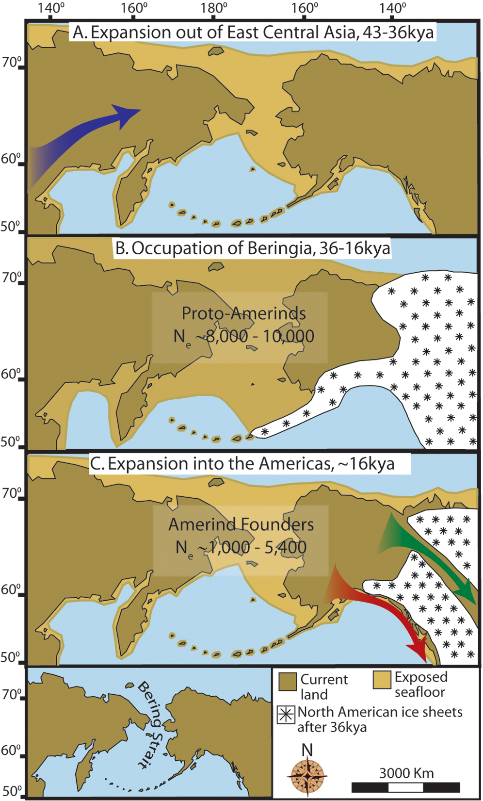
English: Maps depicting each phase of our three-step colonization model for the peopling of the Americas. (A) Divergence, then gradual population expansion of the Amerind ancestors from their East Central Asian gene pool (blue arrow). (B) Proto-Amerind occupation of Beringia with little to no population growth for ~20,000 years. (C) Rapid colonization of the New World by a founder group migrating southward through the ice free, inland corridor between the eastern Laurentide and western Cordilleran Ice Sheets (green arrow) and/or along the Pacific coast (red arrow). In (B), the exposed seafloor is shown at its greatest extent during the last glacial maximum at ~20–18 kya [25]. In (A) and (C), the exposed seafloor is depicted at ~40 kya and ~16 kya, when prehistoric sea levels were comparable [24], [25]. Because of the earth's curvature, the km scale (which is based on the straight line distance at the equator) provides only an approximation of the same distance between two points on these maps. In addition, a scaled-down version of Beringia today (60% reduction of A–C) is presented in the lower left corner. This smaller map highlights the Bering Strait that has geographically separated the New World from Asia since ~11–10 kya. |
| 日期 | 5 October 2009, 05:29 |
| 來源 | doi:10.1371/journal.pone.0001596.g004 |
| 作者 | Buzzzsherman |
| 授權許可 (重用此檔案) |
此檔案採用共享創意 姓名標示-相同方式分享 3.0 未在地化版本授權條款。
|
檔案歷史
點選日期/時間以檢視該時間的檔案版本。
| 日期/時間 | 縮圖 | 尺寸 | 用戶 | 備註 | |
|---|---|---|---|---|---|
| 目前 | 2015年1月18日 (日) 17:26 | | 996 × 1,651(953 KB) | Kopiersperre | high-res |
| 2009年11月5日 (四) 17:37 |  | 361 × 598(191 KB) | Merikanto~commonswiki | {{Information |Description=Maps depicting each phase of our three-step colonization model for the peopling of the Americas. '''(A) Divergence, then gradual population expansion of the Amerind ancestors from their East Central Asian gene pool (blue arrow). |
檔案用途
下列頁面有用到此檔案:
全域檔案使用狀況
以下其他 wiki 使用了這個檔案:
- ast.wikipedia.org 的使用狀況
- ca.wikipedia.org 的使用狀況
- de.wikipedia.org 的使用狀況
- en.wikipedia.org 的使用狀況
- es.wikipedia.org 的使用狀況
- eu.wikipedia.org 的使用狀況
- fi.wikipedia.org 的使用狀況
- fr.wikipedia.org 的使用狀況
- he.wikipedia.org 的使用狀況
- hi.wikipedia.org 的使用狀況
- hy.wikipedia.org 的使用狀況
- it.wikipedia.org 的使用狀況
- ko.wikipedia.org 的使用狀況
- lfn.wikipedia.org 的使用狀況
- pl.wikipedia.org 的使用狀況
- pt.wikipedia.org 的使用狀況
- ru.wikipedia.org 的使用狀況