
File:Lage des Regierungsbezirkes Dresden in Deutschland.GIF
此為最大尺寸。
Lage_des_Regierungsbezirkes_Dresden_in_Deutschland.GIF (176 × 234 像素,檔案大小:3 KB,MIME 類型:image/gif)
摘要
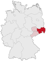
| 描述 | Regierungsbezirk Dresden in Saxony |
| 日期 | |
| 來源 | Karte erstellt auf der Grundlage der opengeodb.de-Umrisse by Geograv |
| 作者 | Geograv |
This image was generated with OpenGeoDB. The information there is placed in the public domain, images generated from OpenGeoDB are derivative works without passing the threshold of creativity, they are therefore also public domain.
| 此檔案不具有著作權,屬於公有領域,因為其所包含之内容均為公共財產且沒有明確的原始作者資訊。 |
檔案歷史
點選日期/時間以檢視該時間的檔案版本。
| 日期/時間 | 縮圖 | 尺寸 | 用戶 | 備註 | |
|---|---|---|---|---|---|
| 目前 | 2006年2月24日 (五) 00:46 | | 176 × 234(3 KB) | Shaqspeare | Regierungsbezirk Dresden in Saxony from German Wikipedia, there described as Karte erstellt auf der Grundlage der opengeodb.de-Umrisse - GNU-FDL {{Bild-GFDL-OpenGeoDB}} {{GFDL}} category:Maps of Germany |
檔案用途
下列頁面有用到此檔案:
全域檔案使用狀況
以下其他 wiki 使用了這個檔案:
- da.wikipedia.org 的使用狀況
- de.wikipedia.org 的使用狀況
- eo.wikipedia.org 的使用狀況
- es.wikipedia.org 的使用狀況
- et.wikipedia.org 的使用狀況
- fi.wikipedia.org 的使用狀況
- fr.wikipedia.org 的使用狀況
- ko.wikipedia.org 的使用狀況
- nl.wikipedia.org 的使用狀況
- pl.wikipedia.org 的使用狀況
- pl.wikivoyage.org 的使用狀況
- pt.wikipedia.org 的使用狀況
- ru.wikipedia.org 的使用狀況
- uk.wikipedia.org 的使用狀況