
File:Land surface temperature anomaly over East Asia in January 2016.jpg
此為最大尺寸。
Land_surface_temperature_anomaly_over_East_Asia_in_January_2016.jpg (720 × 536 像素,檔案大小:236 KB,MIME 類型:image/jpeg)
摘要
| 描述 |
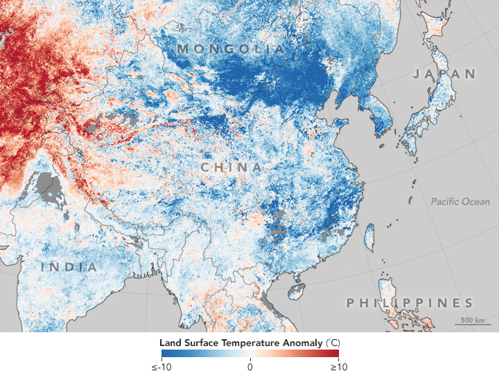
English: This temperature anomaly map is based on data from the Moderate Resolution Imaging Spectroradiometer (MODIS) on NASA’s Terra satellite. It shows land surface temperatures (LSTs) from January 17–24, 2016, compared to the 2001–2010 average for the same eight-day period. |
| 日期 | |
| 來源 | http://earthobservatory.nasa.gov/IOTD/view.php?id=87420 |
| 作者 | NASA |
授權條款
| 本作品由NASA創作,屬於公有領域。根據NASA的版權政策:“NASA的創作除非另有聲明否則不受版權保護。”(參見:Template:PD-USGov/zh,NASA版權政策或JPL圖像使用政策) | ||
 |
警告:
|
檔案歷史
點選日期/時間以檢視該時間的檔案版本。
| 日期/時間 | 縮圖 | 尺寸 | 用戶 | 備註 | |
|---|---|---|---|---|---|
| 目前 | 2016年1月31日 (日) 00:40 | | 720 × 536(236 KB) | Jolly Janner | User created page with UploadWizard |
檔案用途
下列2個頁面有用到此檔案:
全域檔案使用狀況
以下其他 wiki 使用了這個檔案:
- en.wikipedia.org 的使用狀況
- fa.wikipedia.org 的使用狀況
- fi.wikipedia.org 的使用狀況
- hak.wikipedia.org 的使用狀況
- ja.wikipedia.org 的使用狀況
- vi.wikipedia.org 的使用狀況
- zh-min-nan.wikipedia.org 的使用狀況
- zh-yue.wikipedia.org 的使用狀況