
File:Location of Happisburgh.png
預覽大小:490 × 600 像素。 其他解析度:196 × 240 像素 | 392 × 480 像素 | 628 × 768 像素 | 837 × 1,024 像素 | 2,067 × 2,529 像素。
原始檔案 (2,067 × 2,529 像素,檔案大小:795 KB,MIME 類型:image/png)
摘要
| 描述 |
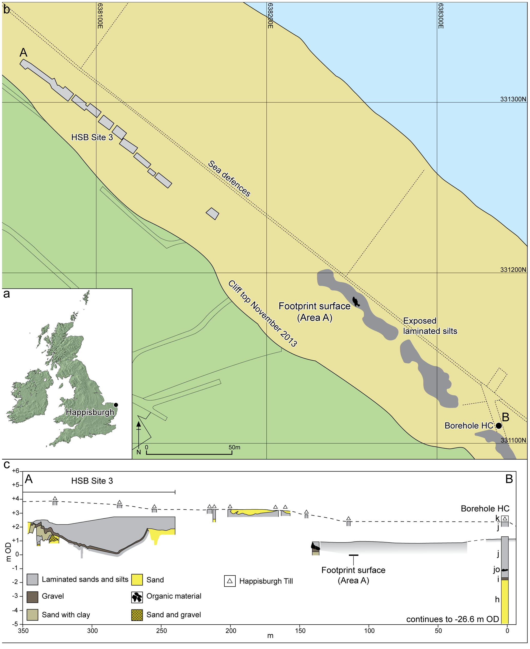
English: Figure 2. Location of Happisburgh. a. Map of UK showing location of Happisburgh; b. Plan of Happisburgh Site 3, exposed and recorded foreshore sediments, location of footprint surface and of borehole HC; c. Schematic cross-section of recorded sediments from Happisburgh Site 3 through to borehole HC showing stratigraphic position of footprint surface. Beds h–k are shown for borehole HC as recorded by West. doi:10.1371/journal.pone.0088329.g002 |
| 日期 | |
| 來源 | Nick Ashton, Simon G. Lewis, Isabelle De Groote, Sarah M. Duffy, Martin Bates, Richard Bates, Peter Hoare, Mark Lewis, Simon A. Parfitt, Sylvia Peglar, Craig Williams, Chris Stringer (2014) Hominin Footprints from Early Pleistocene Deposits at Happisburgh, UK. PLoS ONE 9(2): e88329. doi:10.1371/journal.pone.0088329 |
| 作者 | Nick Ashton, Simon G. Lewis, Isabelle De Groote, Sarah M. Duffy, Martin Bates, Richard Bates, Peter Hoare, Mark Lewis, Simon A. Parfitt, Sylvia Peglar, Craig Williams, Chris Stringer |
| 拍攝地點 | | 位於此地的本圖片與其他圖片: OpenStreetMap |
|---|
授權條款
此檔案採用創用CC 姓名標示 4.0 國際授權條款。
- 您可以自由:
- 分享 – 複製、發佈和傳播本作品
- 重新修改 – 創作演繹作品
- 惟需遵照下列條件:
- 姓名標示 – 您必須指名出正確的製作者,和提供授權條款的連結,以及表示是否有對內容上做出變更。您可以用任何合理的方式來行動,但不得以任何方式表明授權條款是對您許可或是由您所使用。
檔案歷史
點選日期/時間以檢視該時間的檔案版本。
| 日期/時間 | 縮圖 | 尺寸 | 用戶 | 備註 | |
|---|---|---|---|---|---|
| 目前 | 2014年2月7日 (五) 23:46 | | 2,067 × 2,529(795 KB) | BabelStone | User created page with UploadWizard |
檔案用途
下列頁面有用到此檔案:
全域檔案使用狀況
以下其他 wiki 使用了這個檔案:
- ar.wikipedia.org 的使用狀況
- en.wikipedia.org 的使用狀況
- ja.wikipedia.org 的使用狀況