
File:Map of New York highlighting Southern Tier.png
此為最大尺寸。
Map_of_New_York_highlighting_Southern_Tier.png (300 × 232 像素,檔案大小:12 KB,MIME 類型:image/png)
摘要
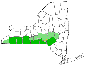
| 描述 | Southern Tier Counties, New York State. Darker green indicates most commonly referred to as "Southern Tier Counties." Light green indicates other counties occasionally associated with the Southern Tier. |
| 日期 | 2004年一月30日 (原始上傳日期) |
| 來源 | 本檔案是從en.wikipedia轉移到維基共享資源。 |
| 作者 | Later versions were uploaded by JMyrleFuller at en.wikipedia. |
授權條款
| 此檔案採用共享創意 姓名標示-相同方式分享 3.0 未在地化版本授權條款。 受免責聲明的約束。 | ||
| ||
| 已新增授權條款標題至此檔案,作為GFDL授權更新的一部份。 |

|
已授權您依據自由軟體基金會發行的無固定段落、封面文字和封底文字GNU自由文件授權條款1.2版或任意後續版本,對本檔進行複製、傳播和/或修改。該協議的副本列在GNU自由文件授權條款中。 受免責聲明的約束。 |
原始上傳日誌
原始描述頁面位於這裡。下列使用者名稱均來自en.wikipedia。
- 2007-07-07 21:12 JMyrleFuller 300×232×8 (12702 bytes) Modification of Decumanus's map to correct counties. Darker greens indicate most commonly referred to as Southern Tier Counties, whereas light green indicates less frequently used.
- 2004-01-30 08:59 Decumanus 300×232×8 (11837 bytes) Southern Tier Counties, New York State
檔案歷史
點選日期/時間以檢視該時間的檔案版本。
| 日期/時間 | 縮圖 | 尺寸 | 用戶 | 備註 | |
|---|---|---|---|---|---|
| 目前 | 2007年7月29日 (日) 05:13 | | 300 × 232(12 KB) | Whhalbert | {{Information |Description=Southern Tier Counties, New York State. Darker green indicates most commonly referred to as "Southern Tier Counties." Light green indicates other counties occasionally associated with the Southern Tier. |Source=Originally from [ |
檔案用途
全域檔案使用狀況
以下其他 wiki 使用了這個檔案:
- en.wikipedia.org 的使用狀況
- en.wiktionary.org 的使用狀況
- pt.wikipedia.org 的使用狀況