
File:Montreal1764CedarsDetail.png

預覽大小:800 × 523 像素。 其他解析度:320 × 209 像素 | 640 × 418 像素 | 1,067 × 697 像素。
原始檔案 (1,067 × 697 像素,檔案大小:1.19 MB,MIME 類型:image/png)
摘要
| 描述 |
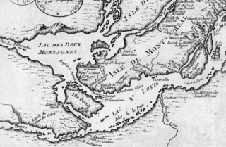
English: This is a detail of the original source map, cropped to depict the western part of the Isle of Montreal and immediately surrounding mainland as far as Les Cèdres. The map's caption reads "Montreal et ses Environs" (Montreal and its environs). It depicts a number of places relevant to the 1776 Battle of the Cedars. |
| 日期 | |
| 來源 | Bibliothèque Nationale de France http://gallica2.bnf.fr/ark:/12148/btv1b67001778 |
| 作者 | Bellin, Jacques-Nicolas, for the Kingdom of France |
| 其他版本 | IsleDeMontreal1764.png |
授權條款
|
本作品在其來源國以及其他版權期限是作者逝世後100年或以下的國家與地區屬於公有領域。 | |
| 此作品無已知的著作權限制,亦不受所有相關和鄰接的權利限制。 | |
檔案歷史
點選日期/時間以檢視該時間的檔案版本。
| 日期/時間 | 縮圖 | 尺寸 | 用戶 | 備註 | |
|---|---|---|---|---|---|
| 目前 | 2009年1月23日 (五) 22:57 | | 1,067 × 697(1.19 MB) | Magicpiano | {{Information |Description={{en|1=This is a detail of the original source map, cropped to depict the western part of the Isle of Montreal and immediately surrounding mainland as far as Les Cèdres. The map's caption reads "Montreal et ses Environs" (Mont |
檔案用途
下列頁面有用到此檔案:
全域檔案使用狀況
以下其他 wiki 使用了這個檔案:
- ar.wikipedia.org 的使用狀況
- en.wikipedia.org 的使用狀況
- it.wikipedia.org 的使用狀況
- ja.wikipedia.org 的使用狀況
- nl.wikipedia.org 的使用狀況
- www.wikidata.org 的使用狀況