
File:NUTS 3 regions of Northern Ireland map.svg

此 SVG 檔案的 PNG 預覽的大小:705 × 599 像素。 其他解析度:282 × 240 像素 | 565 × 480 像素 | 903 × 768 像素 | 1,205 × 1,024 像素 | 2,409 × 2,048 像素 | 1,208 × 1,027 像素。
原始檔案 (SVG 檔案,表面大小:1,208 × 1,027 像素,檔案大小:163 KB)
摘要
| 描述 |
Deutsch: Karte von Nordirland: NUTS-Raumeinheiten auf den Ebenen NUTS3.
Quadratische Plattkarte, N-S-Streckung 170 %. Geographische Begrenzung der Karte:
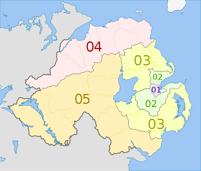
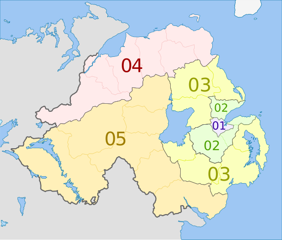
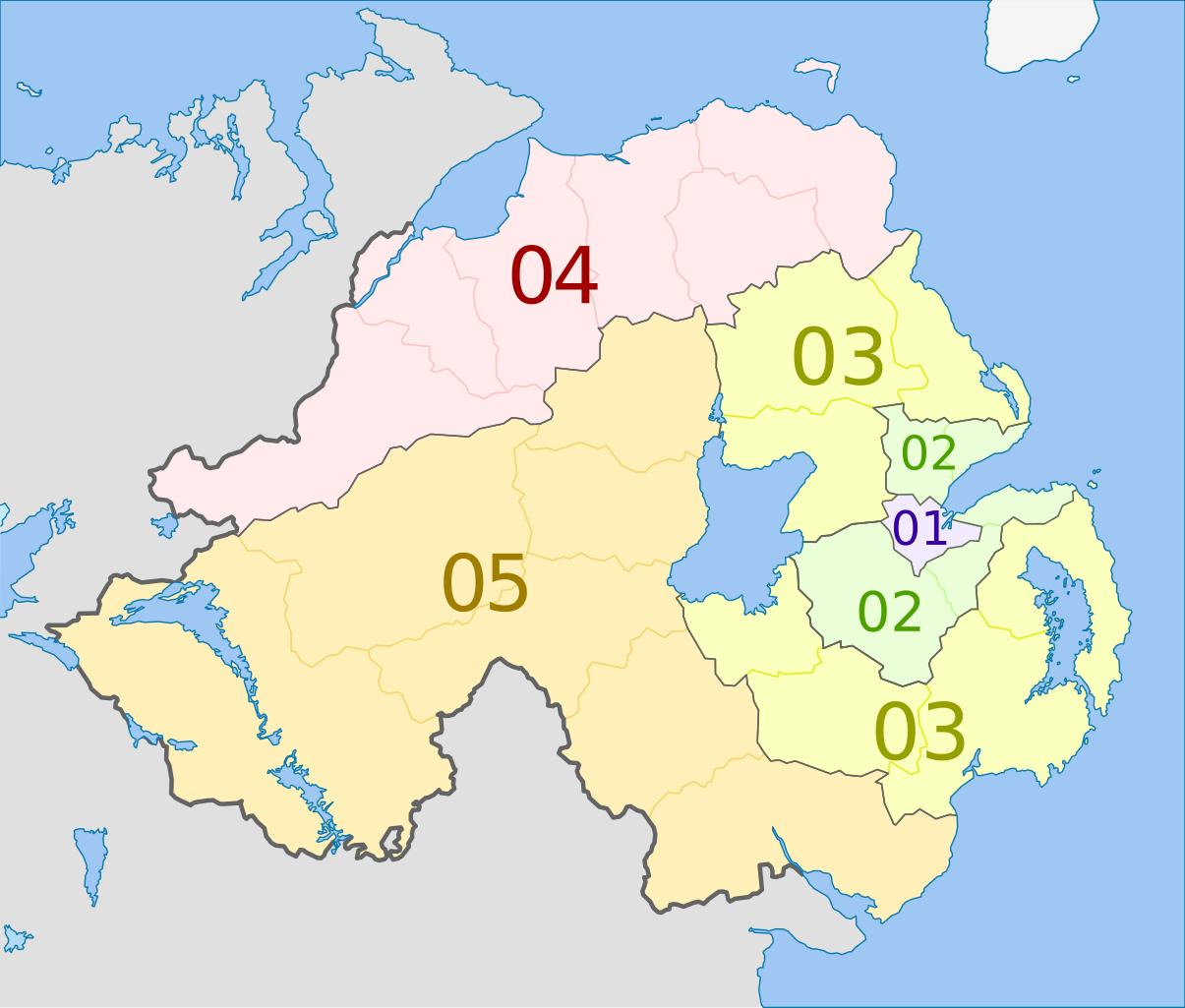
English: Map of the NUTS 3 regions of Northern Ireland.
Equirectangular projection, N/S stretching 170 %. Geographic limits of the map:
|
| 日期 | (UTC) |
| 來源 |
本檔案衍生自: Northern Ireland location map.svg: |
| 作者 |
|
| NUTS 1 | Code | NUTS 2 | Code | NUTS 3 | Code |
|---|---|---|---|---|---|
| Northern Ireland | UKN | Northern Ireland | UKN0 | Belfast | UKN01 |
| Outer Belfast (Carrickfergus, Castlereagh, Lisburn, Newtownabbey, North Down) | UKN02 | ||||
| East of Northern Ireland (Antrim, Ards, Ballymena, Banbridge, Craigavon, Down, Larne) | UKN03 | ||||
| North of Northern Ireland (Ballymoney, Coleraine, Derry, Limavady, Moyle, Strabane) | UKN04 | ||||
| West and South of Northern Ireland (Armagh, Cookstown, Dungannon, Fermanagh, Magherafelt, Newry and Mourne, Omagh) | UKN05 |
授權條款
我,本作品的著作權持有者,決定用以下授權條款發佈本作品:
此檔案採用共享創意 姓名標示-相同方式分享 3.0 未在地化版本授權條款。
姓名標示: Dr Greg and NordNordWest
- 您可以自由:
- 分享 – 複製、發佈和傳播本作品
- 重新修改 – 創作演繹作品
- 惟需遵照下列條件:
- 姓名標示 – 您必須指名出正確的製作者,和提供授權條款的連結,以及表示是否有對內容上做出變更。您可以用任何合理的方式來行動,但不得以任何方式表明授權條款是對您許可或是由您所使用。
- 相同方式分享 – 如果您利用本素材進行再混合、轉換或創作,您必須基於如同原先的相同或兼容的條款,來分布您的貢獻成品。
原始上傳日誌
This image is a derivative work of the following images:
- File:Northern_Ireland_location_map.svg licensed with Cc-by-sa-3.0
- 2009-09-22T18:02:38Z NordNordWest 1208x1027 (166284 Bytes)
- 2009-07-04T20:14:31Z NordNordWest 1208x1027 (167876 Bytes)
- 2009-07-04T20:10:20Z NordNordWest 1208x1027 (167239 Bytes) {{Information |Description= {{de|Positionskarte von [[:de:Nordirland|Nordirland]]}} Quadratische Plattkarte, N-S-Streckung 170 %. Geographische Begrenzung der Karte: * N: 55.4° N * S: 53.9° N * W: 8.3° W * O: 5.3° W {{en|
Uploaded with derivativeFX
檔案歷史
點選日期/時間以檢視該時間的檔案版本。
| 日期/時間 | 縮圖 | 尺寸 | 用戶 | 備註 | |
|---|---|---|---|---|---|
| 目前 | 2012年6月5日 (二) 00:20 | | 1,208 × 1,027(163 KB) | Dr Greg | == {{int:filedesc}} == {{Information |Description={{de|Karte von Nordirland: de:NUTS-Raumeinheiten auf den Ebenen NUTS3. Quadratische Plattkarte, N-S-Streckung 170 %. Geographische Begrenzung der Karte: * N: 55.4° N * S: ... |
檔案用途
下列頁面有用到此檔案:
全域檔案使用狀況
以下其他 wiki 使用了這個檔案:
- ar.wikipedia.org 的使用狀況
- de.wikipedia.org 的使用狀況
- en.wikipedia.org 的使用狀況
- fi.wikipedia.org 的使用狀況
- it.wikipedia.org 的使用狀況
- ja.wikipedia.org 的使用狀況
- lt.wikipedia.org 的使用狀況
- ru.wikipedia.org 的使用狀況
- uk.wikipedia.org 的使用狀況