
File:Regions of NZ Numbered.svg

此 SVG 檔案的 PNG 預覽的大小:290 × 415 像素。 其他解析度:168 × 240 像素 | 335 × 480 像素 | 537 × 768 像素 | 715 × 1,024 像素 | 1,431 × 2,048 像素。
原始檔案 (SVG 檔案,表面大小:290 × 415 像素,檔案大小:283 KB)
摘要
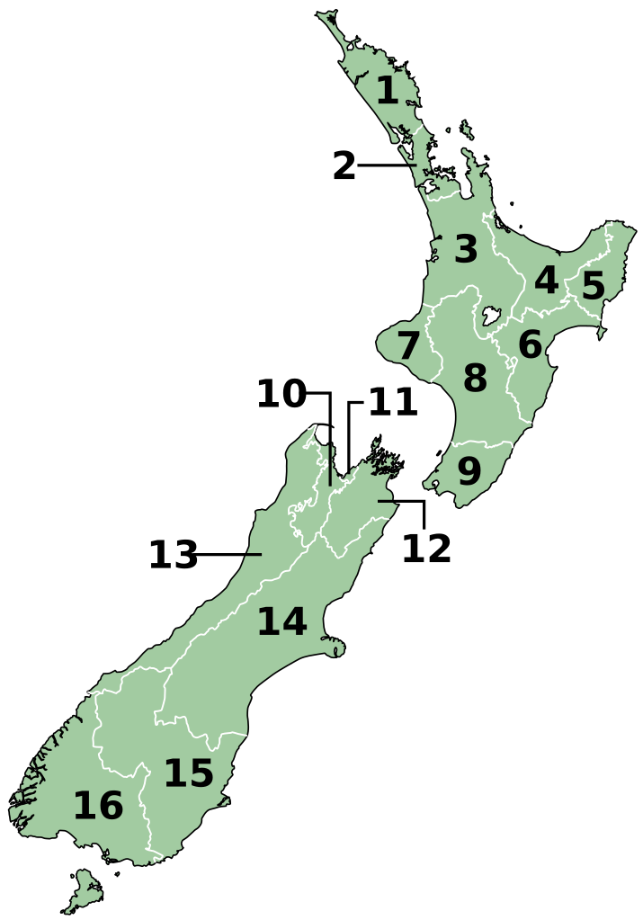
| 描述 | vector map of local government regions of New Zealand. Based on Image:NZ_Regions.svg by Ozhiker |
| 日期 | |
| 來源 |
自己的作品 |
| 作者 | Benchill |
1. Northland Region
2. Auckland Region
3. Waikato Region
4. Bay of Plenty Region
5. Gisborne Region
6. Hawke's Bay Region
7. Taranaki Region
8. Manawatu-Wanganui Region
9. Wellington Region
10. Tasman Region
11. Nelson Region
12. Marlborough Region
13. West Coast Region
14. Canterbury Region
15. Otago Region
16. Southland Region
授權條款
我,本作品的著作權持有者,決定用以下授權條款發佈本作品:

|
已授權您依據自由軟體基金會發行的無固定段落、封面文字和封底文字GNU自由文件授權條款1.2版或任意後續版本,對本檔進行複製、傳播和/或修改。該協議的副本列在GNU自由文件授權條款中。 |
| 此檔案採用共享創意 姓名標示-相同方式分享 3.0 未在地化版本授權條款。 | ||
| ||
| 已新增授權條款標題至此檔案,作為GFDL授權更新的一部份。 |
此檔案採用創用CC 姓名標示-相同方式分享 2.5 通用版授權條款。
- 您可以自由:
- 分享 – 複製、發佈和傳播本作品
- 重新修改 – 創作演繹作品
- 惟需遵照下列條件:
- 姓名標示 – 您必須指名出正確的製作者,和提供授權條款的連結,以及表示是否有對內容上做出變更。您可以用任何合理的方式來行動,但不得以任何方式表明授權條款是對您許可或是由您所使用。
- 相同方式分享 – 如果您利用本素材進行再混合、轉換或創作,您必須基於如同原先的相同或兼容的條款,來分布您的貢獻成品。
您可以選擇您需要的授權條款。
檔案歷史
點選日期/時間以檢視該時間的檔案版本。
| 日期/時間 | 縮圖 | 尺寸 | 用戶 | 備註 | |
|---|---|---|---|---|---|
| 目前 | 2022年6月15日 (三) 12:48 | | 290 × 415(283 KB) | Pacha Tchernof | Fixed a border of Waikato Region near the lake as it was requested in PNG-version of the file (Media for cleanup) |
| 2007年9月25日 (二) 11:50 |  | 290 × 415(282 KB) | Benchill | {{Information |Description= vector map of local government regions of New Zealand. Based on Image:NZ_Regions.svg by Ozhiker |Source= self-made using Inkscape |Date= 2007-09-25 |Author= Benchill }} == Licensing == { |
檔案用途
下列頁面有用到此檔案:
全域檔案使用狀況
以下其他 wiki 使用了這個檔案:
- an.wikipedia.org 的使用狀況
- ar.wikipedia.org 的使用狀況
- ast.wikipedia.org 的使用狀況
- ban.wikipedia.org 的使用狀況
- bg.wikipedia.org 的使用狀況
- ca.wikipedia.org 的使用狀況
- ckb.wikipedia.org 的使用狀況
- cs.wikipedia.org 的使用狀況
- cy.wikipedia.org 的使用狀況
- en.wikipedia.org 的使用狀況
- eo.wikipedia.org 的使用狀況
- es.wikipedia.org 的使用狀況
- fi.wikipedia.org 的使用狀況
- fo.wikipedia.org 的使用狀況
- frr.wikipedia.org 的使用狀況
- fr.wikipedia.org 的使用狀況
- gl.wikipedia.org 的使用狀況
- ha.wikipedia.org 的使用狀況
- hr.wikipedia.org 的使用狀況
- hu.wikipedia.org 的使用狀況
- id.wikipedia.org 的使用狀況
- it.wikipedia.org 的使用狀況
- ja.wikipedia.org 的使用狀況
- ka.wikipedia.org 的使用狀況
- mi.wikipedia.org 的使用狀況
- mk.wikipedia.org 的使用狀況
- ms.wikipedia.org 的使用狀況
- nn.wikipedia.org 的使用狀況
檢視此檔案的更多全域使用狀況。