
File:Satellite Image of Kumtag Desert 92.65632E 39.91302N.png

預覽大小:800 × 386 像素。 其他解析度:320 × 154 像素 | 640 × 309 像素 | 1,282 × 618 像素。
原始檔案 (1,282 × 618 像素,檔案大小:1.57 MB,MIME 類型:image/png)
| 描述 |
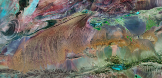
English: Satellite Image of the "Big Ear" in Lop Nur (left) and of the Kumtag Desert (middle) and Astintag (right) in Xinjiang, China.
Deutsch: Satellitenbild von dem "Großen Ohr" in Lop Nor (links) und von der Kumtag Wüste (Mitte) und der Hochebene des Astintag (rechts) in Xinjiang, China.
|
|||
| 來源 | NASA World Wind - Geocover 2000 layer | |||
| 作者 | NASA | |||
| 授權許可 (重用此檔案) |
|

檔案歷史
點選日期/時間以檢視該時間的檔案版本。
| 日期/時間 | 縮圖 | 尺寸 | 用戶 | 備註 | |
|---|---|---|---|---|---|
| 目前 | 2009年7月7日 (二) 16:24 | | 1,282 × 618(1.57 MB) | Camphora | {{Information |Description={{en|1=Satellite Image of Kumtag Desert, China }} {{zh|1=库姆塔格沙漠卫星影像,上北下南 最左侧的大耳朵为罗布泊,最右侧的小块沙� |
檔案用途
下列頁面有用到此檔案:
全域檔案使用狀況
以下其他 wiki 使用了這個檔案:
- de.wikipedia.org 的使用狀況
- en.wikipedia.org 的使用狀況
- fr.wikipedia.org 的使用狀況
- ja.wikipedia.org 的使用狀況
- pl.wikipedia.org 的使用狀況